A Tinsley Hill Phase Mississippian Occupation at the Confluence of the Tennessee and Ohio Rivers
Richard L. Herndon and Andrew P. Bradbury
Abstract
This article summarizes the results of excavations at Chestnut Lake, a late Mississippian Tinsley Hill phase (cal A.D. 1300–1450) household located in the lower Ohio River valley. The small portion of the site investigated resulted in the documentation of a rebuilt wall trench structure which appears to have been burned. Analyses of the recovered materials and their spatial relationships allowed the identification of hearth related activity areas inside the structure. No features were identified outside the building, indicating that all related activities were likely conducted inside. The presence of cannel coal celts, galena, non-local cherts, and ceramic ear plugs suggest a higher status family occupied the residence. The relationship of Chestnut Lake to other Tinsley Hill phase occupations in the region is considered.
The lower Ohio River valley has long been a focal point for the study of Mississippian communities. As noted by Muller (1986:173), there has been a tendency for the majority of this research to over-emphasize the large or high-profile settlements in the region and underrepresent the much more numerous smaller sites and communities. He goes on to note that part of the reason for the lack of research on small Mississippian sites is that they are typically difficult to identify archaeologically, but also because such sites tend to be viewed by researchers as data-limited or uninteresting. In a later publication, Muller (1997:183–224, 257–270) partly addresses this oversight by devoting considerable attention to small Mississippian sites in the lower Ohio valley; in this case, particularly relating them to processes of production and reproduction within the larger political economy. While a significant contribution to our understanding of the economic role of households and farmsteads within Mississippian society, in reality there is very little data concerning actual activities conducted in or around these houses.
In a seminal article in that same year, Clay (1997) rewrote the social and political landscape of the late Mississippian in the lower Ohio valley using data primarily, but not exclusively, recovered from smaller sites. In his view, site activities, such as abandonment/reoccupation, site structure, and chronology are far easier to reconstruct at smaller sites. These data in turn provided a corpus of data for Clay to reinterpret regional settlement patterns and the evolution of political and social change from preceding Mississippian systems. Like Muller, however, Clay does not incorporate specific data concerning the economic activities conducted at the level of the household.
For both Muller and Clay, the omission of this information in their research is completely understandable since very few houses or households with intact floors have been identified and excavated in the region. This is an important point as the lack of intact floors in houses renders discussion of household activity areas exclusively to the domain of features and their contents. Although a perfectly acceptable approach to reconstructing past activities on a site, feature data can be of limited research value. For example, pit refuse from household tasks are often disassociated from where the task was performed. Also, pit refuse often contains the remains of multiple tasks that are difficult to parse out once commingled.
This article attempts to partly address the lack of detailed analyses of households in the lower Ohio valley by presenting the results of excavations conducted at Chestnut Lake (15Lv222). This site was a small late Mississippian Tinsley Hill phase (cal A.D. 1300–1450) community near the confluence of the Ohio and Tennessee rivers. Investigations were limited to a small portion of the entire site with most of the effort focused on a single household which was nearly completely uncovered. Since the floor of the last structure built was intact, the current excavations presented a rare opportunity to identify discrete activity areas in and adjacent to the household in the region dating to this time. Following Clay (1997), the occupation at Chestnut Lake is then evaluated at the regional level in the hopes of further refining our understanding in what appears to be a substantial transformation of the existing social and political landscape during the late Mississippian in the lower Ohio valley.
Site Description and Summary of Investigations
Chestnut Lake is located on a prominent Wisconsin-aged terrace overlooking the Tennessee River (Figure 1). Site area within the project corridor was approximately 7,500 sq m (.7 ha [1.8 acres]). Artifacts were present on the ground surface outside the corridor to the northwest and southeast, indicating that the site extended outside the project boundaries. A larger site size was also indicated by the landowner who stated that pits containing projectile points were found by the previous landowners when they erected a grain silo on the property. This silo was just outside the project area to the southeast near the terrace edge. Over the years the current landowner has collected artifacts from all around the site, including a complete Mississippian teardrop-shaped hoe, Mississippian Triangular Cluster hafted bifaces as well as shell tempered pottery. If the scatter of artifacts indicated by the landowner and as seen on the ground during the investigations are an accurate gauge of site size, then Chestnut Lake could be at least 1.6 ha (4 acres) in area, but probably somewhat less.
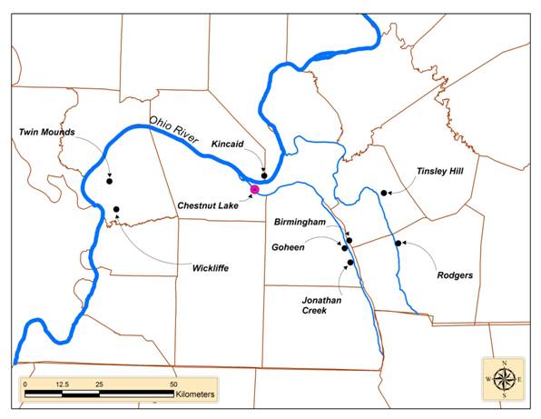
Figure 1. Location of the Chestnut Lake site and other late Mississippian sites discussed.
Geophysical Survey and Feature Analysis
After arriving at the site, it was discovered that the landowner had mechanically removed all the topsoil from across the site. No evidence of features was present on the bladed surface, although artifacts were ubiquitous. In order to determine if any intact features were still present below the bladed surface, a magnetometer survey was conducted (Clay 2003:74–79). Beyond a scattering of dipole signals likely the result of random historic metal, only one area of the site returned a signature that suggested a possible prehistoric magnetic anomaly. This anomaly was located in the southeastern portion of the project corridor. As shown in Figure 2, the anomaly appears to have had a roughly oval shape with internal features generally consistent with Mississippian structures.
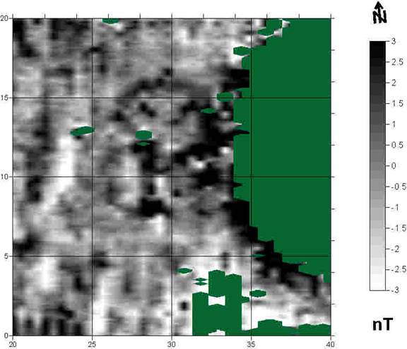
Figure 2: Magnetometer survey of area over Structure 2.
Hand excavation of 29 1x1 m units in and around the anomaly resulted in the near complete exposure of a Mississippian wall trench structure (Figure 3). Based on unit profiles, the structure floor was located under an approximately 20 cm-thick Mississippian occupation zone consisting of moderate amounts of shell-tempered pottery, lithic debitage, and charcoal flecking. In some places the very top portion of the occupation zone had been impacted by the mechanical stripping that occurred before our arrival. In other places, remnants of the plow zone were still clearly visible overlying the undisturbed occupation zone. Given these circumstance, the structure was never impacted by these pre-investigation activities. Approximately 460 sq m of mechanical stripping around the excavation block did not result in the identification of any additional pit features or structures.
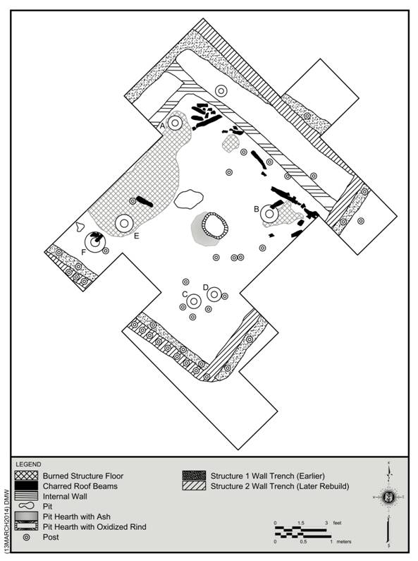
Figure 3.Overview of Structure 1 and 2 and the spatial distribution of features.
As can be seen in Figure 3, hand excavations resulted in the exposure of approximately 75–80 percent of the area encompassed within the wall trenches, resulting in the identification of two superimposed structures. Structure 1 was the earliest and had an internal floor area of approximately 19 sq m. The wall trenches of this building were approximately 20 cm wide and 40–50 cm deep. When identified, post holes were widely spaced and ranged between 10 and 14 cm in diameter. This was most clearly evident in the south and west wall trenches. Structure 2 superimposed Structure 1 and encompassed a floor area of approximately 20 sq m. Wall trenches of this structure were approximately 15 cm wide and 50–65 cm in depth. As shown in the west wall trench of this structure, post holes were closely spaced and tended to be 10–13 cm in diameter.
A very shallow linear stain in the interior portion of Structure 2 paralleled both its northern and eastern walls. Only approximately 11 cm in depth and 15 cm wide, this stain did not exhibit any evidence of post holes, although multiple small diameter post holes were located immediately adjacent to it along its length. Given its shallowness, lack of internal post holes, and no evidence of extending outside the walls of Structure 2, this linear stain is interpreted as being related to a raised wooden platform or bench. The smaller diameter posts along its edges were likely supports for the bench.
Other features identified within the confines of Structure 2 consisted of superimposed centralized hearths, a subterranean pit located just north of the hearths, internal posts, and portions of the original house floor that had been burned. The earlier of the hearths did not exhibit evidence of in-situ burning but did contain a layer of ash at the bottom. The later hearth had a rind of in-situ burning ringing it but little else. The shallow pit to the north of the hearths had a rounded base and out-flaring walls and contained a very low density of small-sized artifacts.
In addition to numerous small post holes, six larger post holes were also present. These larger posts (A–F) were located in the corners of Structure 2 inside the area that was interpreted as the raised sleeping platform along the north and east walls. These post holes ranged from 22–33 cm in diameter. The one larger post that was excavated resulted in a depth of about 35–40 cm with the profile showing straight sides and a rounded base. Lastly, portions of the intact floor likely associated with Structure 2 had been fired hardened when the building burned and collapsed in on itself. This was especially visible in the north and east portion of the building. On top of the floor in these burned areas were numerous beams that had formerly been part of the roof or walls as well as daub.
Radiocarbon Dates and Mississippian Chronology
Table 1 presents the radiocarbon data for the two carbon samples submitted for chronometric dating. Each date was calibrated using the INTCAL98 procedure (Stuiver et al. 1998). The Beta 177944 sample was taken from charred oak excavated from Post Hole F (a corner post of Structure 2). The Beta 177945 sample, also from charred oak, came from a wooden beam lying on the intact floor that had been part of the roof or wall of Structure 2. These two dates have intercepts of cal A.D. 1420 and AD 1320, 1350, and 1390. At the 2-sigma range both samples appreciably overlap while the 1-simga ranges barely do so.
Table 1. Summary of Radiocarbon Dates from Chestnut Lake.
|
Lab No. |
Provenience |
Measured Radiocarbon Age |
C13/C12 Ratio |
Conventional Radiocarbon Age |
Cal. Range 2 sigma |
Calibrated Intercept |
Cal. Range 1 sigma |
|
|
Beta-177944 |
Post Hole F |
530±50 BP |
-25.8 0/00 |
520±50 BP |
AD 1310 to 1360, 1390 to1450 |
AD 1420 |
AD 1400 to1430 |
|
|
Beta-177945 |
Unit 28, Lev. 2 |
620±50 BP |
-26.0 0/00 |
610±50 BP |
AD 1290 to 1420 |
AD 1320,1350,1390 |
AD 1300 to1410 |
As currently understood, the Mississippian sequence within the lower Ohio valley, including the portion of Kentucky where the Chestnut Lake site is located, consists of three phases: Jonathan Creek, Angelly/Kincaid, and Tinsley Hill (Butler 1991; Clay 1997; Muller 1986). The Jonathan Creek phase is synonymous with early Mississippian and dates between cal A.D. 1000–1150. The middle portion of the sequence has been variously labeled as the Angelly or Kincaid phase. The date range for this phase is cal A.D. 1150–1300. The late Mississippian ranges between cal A.D. 1300–1450 and is referred to as the Tinsley Hill phase. The radiocarbon dates from Chestnut Lake places the Mississippian occupation at this site firmly within the Tinsley Hill phase.
The Tinsley Hill phase construct was based primarily on the late Mississippian occupations at the Tinsley Hill site (15Ly18) in Lyon County, Kentucky (Clay 1963a, 1963b, 1979). Late Mississippian components there included structures from the village area located on the floodplain and a stone box cemetery located on an adjacent bluff. A radiocarbon date from the center post of one of the village structures returned a calibrated intercept of A.D. 1380 with a two-sigma range of A.D. 1330–1430. Another radiocarbon date from the cemetery had a similar calibrated intercept of A.D 1360 (Clay 1997:19,23). Other Tinsley Hill phase components have also been identified at Rodgers (15TR17), Birmingham (15Ml8) and Goheen (15Ml14), but these sites have only been dated based on their ceramic assemblages.
Another possible Tinsley Hill phase hamlet is the Steam site (15McN24) located on the Ohio floodplain in just west of Paducah in McCracken County, Kentucky. Excavations revealed portions of multiple wall trench structures and pits (Butler et al. 1981; Kreisa 1995:161–177). One radiocarbon date had a two-sigma range of cal A.D. 1290–1474 with an intercept of A.D. 1373 and fits comfortably within the Tinsley Hill phase time span. Another date had a two-sigma range of cal A.D. 1288–1637 and an intercept of A.D.1418.The front end of this date falls within the Tinsley Hill phase as well, but the end of the date range is clearly too late. Based on the ceramic from the site, however, both Butler et al. (1981) and Kreisa (1995:169) assigns the site occupation to the preceding Angelly/Kincaid phase.
Also just west of Paducah is the Rowlandtown site (15McN3), a mound and village center located on the Ohio River. Although not currently assigned to the Tinsley Hill phase, a Late Mississippian occupation was identified in the top and bottom zones of the mound (Wesler 2006:142–155), as well as, in the village (Kreisa 1991:37). Near the top of the mound a calibrated two-sigma date of A.D. 1263–1394 was taken from a wall trench structure. Toward the bottom of the mound a corn cob fragment had a two-sigma calibrated date range of A.D. 1222–1394. The village date had a calibrated date range of A.D. 1285–1464.
Ceramic Analysis
A total of 967 sherds larger than 2 cm in size were recovered from in or immediately adjacent to the Mississippian structures at Chestnut Lake. This number includes 44 rims. When possible, sherds were identified by type and variety as established by Phillips et al. (1951) and later modified by Phillips (1970), Clay (1979), Lewis and Mackin (1984, 1986), Muller (1986), Pollack and Railey (1987), and Wesler (2001). Table 2 compares the frequencies and percentages of each ceramic type identified. As can be seen, most of the material is Mississippian, although a few sherds of Early/Middle Woodland (Baumer) and Late Woodland (Lewis) were also present. In addition to the sherds, 254 pieces of burned clay and 68 pieces of daub were identified. Finally, two ceramic ear plugs and a ceramic ear spool or ring were present on the intact floor.
Table 2. Tabulation of ceramic types.
|
Ceramic Type |
Count |
Percent |
Weight (g) |
Percent |
|
Mississippi Plain |
805 |
83.3 |
1,958.10 |
73.6 |
|
Bell Plain |
105 |
10.8 |
208.6 |
7.8 |
|
Kimmswick Fabric Impressed |
19 |
2 |
291.4 |
11 |
|
Unclassified |
17 |
1.8 |
53.1 |
2 |
|
Kimmswick Plain |
8 |
0.8 |
109.8 |
4.1 |
|
Lewis |
7 |
0.7 |
19.6 |
0.7 |
|
Baumer |
2 |
0.2 |
2.6 |
0.1 |
|
Matthews Incised |
2 |
0.2 |
7.9 |
0.3 |
|
Negative Painted var. Angel |
2 |
0.2 |
9.9 |
0.4 |
|
967 |
100 |
2,661.00 |
100 |
Based on rims and distinctive body sherds, it is estimated that 68 different Mississippian vessels were present within the assemblage (Table 3). Approximately 73 percent could be assigned a vessel form. The majority of those were coarse shell tempered Mississippi Plain jars and Kimmswick Fabric Impressed or Plain salt pans. In the case of the jars some exhibited sooting or fireclouds on the exterior surface, indicating their use in cooking activities. This is in accordance with interpretations that these vessels are well-suited to cooking or heat related activities (Hally 1983, 1986; Welch and Scarry 1995; Wesler 2001). The salt pans are generally considered to have functioned as all-purpose cooking utensils in addition to their use as salt pans (Muller 1986, Wesler 2001). These vessels tend to be shallow with wide flaring rims and thick vessel walls. Many of the remaining vessel forms were coarse or fine shell tempered bottles, plates (Figure 4), bowls, and miniature pots. These vessels have typically been interpreted as serving ware (Hally 1983, 1986; Welch and Scarry 1995; Wesler 2001). At Chestnut Lake, many of these vessels (although not the miniature pots) were heavily burnished or exhibited a brown to red colored slip on one or both surfaces. None of these serving vessels had evidence of having been used in cooking activities.

Figure 4. Negative painted sherds.
Table 3. Individual Mississippian vessels by ceramic type and vessel form.
|
|
Jars |
Salt Pans |
Bottles |
Plates |
Bowls |
Miniature Vessels |
Indeterminate |
Total |
|
Mississippi Plain |
16 |
0 |
1 |
2 |
1 |
2 |
12 |
34 |
|
Bell Plain |
2 |
0 |
7 |
0 |
4 |
0 |
3 |
16 |
|
Kimmswick Fabric Impressed |
0 |
11 |
0 |
0 |
0 |
0 |
0 |
11 |
|
Kimmswick Plain |
0 |
2 |
0 |
0 |
0 |
0 |
0 |
2 |
|
Matthews Incised |
0 |
0 |
0 |
0 |
0 |
0 |
3 |
3 |
|
Negative Painted var. Angel |
0 |
0 |
0 |
2 |
0 |
0 |
0 |
2 |
|
18 |
13 |
8 |
4 |
5 |
2 |
18 |
68 |
As originally defined, the Tinsley Hill phase ceramic assemblage was based on the Tinsley Hill III ceramic complex defined at the type site (Clay 1979, 1997:19). Pottery within this phase included the types Mississippian Plain, Bell Plain, Kimmswick Fabric Impressed, McKee Cord-marked, and Old Town Red, which were noted in the previous Kincaid or Angelly phase (Clay 1979, 1997:19; Riordan 1975:173–174). In addition to those, Kimmswick Plain, Nashville Negative Painted (var. Nashville), and O’Byam Incised (var. Stewart) (Clay 1979:115) were present during this phase, although negative painting in general is known to have started around cal A.D. 1200. Wide strap handles predominate on jars and the full range of vessel forms will be present (Butler 1991:267). Notable absences within the Chestnut Lake vessel assemblage were O’Byam Incised plates and strap handles, but these omissions are likely due to the small size of the vessel assemblage.
Lithic Analysis
A total of 610 flakes largerer than .25 inch and 612 flakes smaller than .25 inch were recovered. In addition, 99 pieces of thermal shatter, 36 fragments of fire-cracked rock, 32 chipped stone implements, one whole cannel coal celt and a fragment of a second, four cobble tools, one piece of unworked galena, and ten cores were also identified. A variety of raw materials were used for chipped stone tool production. Mounds Gravel dominates the flake debris (N = 232, 53.0 percent), though relatively high amounts of Elco/Dover/Lower St. Louis [EDL] (N = 130, 21.3 percent) and Mill Creek (N = 87, 14.3 percent) were also recovered. Lesser amounts of Cobden (N = 34, 5.6 percent) and Burlington (N = 1, 0.2 percent) were also identified. Approximately 28 percent of the Mill Creek flakes exhibit hoe polish on their dorsal face and/or platform and likely represent re-sharpening or recycling of hoes.
Reduction stage data indicated very different use of local and non-local sources (Figure 5). Mounds Gravel exhibits an emphasis on early stage reduction. Given the close proximity of the site to the source, and the quality/size of Mounds Gravel, this is not too surprising. This material was mostly used for expedient tool production. The non-local sources (EDL, Mill Creek, and Cobden) all show higher amounts of middle and late stage debris than Mounds Gravel. Of these three cherts, EDL has the highest amount of early stage debris represented. This is likely a reflection of the proximity of the source to the site. EDL chert can be procured approximately 30 km or less from the site while the other sources are more distant at 60 km.
Several inferences can be suggested concerning the use of the various chert types at the site. Mounds Gravel was predominantly used for expedient tool production (utilized flakes). Minor amounts of tool production may also have taken place. Flake debris of Mill Creek was likely the result of the recycling of hoes and/or other large bifaces. These implements would have arrived at the site in finished form. Flakes removed from these tools would have been used as expedient tools or blanks for the production of other tools. EDL flake debris represents a mix of core reduction and tool production. Finally, flake debris of Cobden was predominantly from tool manufacture and maintenance. With the exception of two bifaces of an indeterminate, local chert, all of the modified implements were of non-local sources (Figure 6). Cores were predominantly of Mounds Gravel.
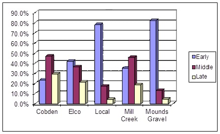 Figure 5. Raw material by reduction stage. |
 Figure 6. Modified implements and cores by raw material type. |
The organization of lithic technology at Chestnut Lake was similar to that of other Mississippian sites in the area. Parry and Kelly (1987) and Teltser (1991) noted a shift from formal tool production (large bifaces) to a flake-tool technology in the Late Woodland to Early Mississippian period. Some formal tools were still used (e.g., hoes and other bifaces), but a greater emphasis on amorphous cores and expedient flake tools is seen. Parry and Kelly (1987) view this shift as the result of decreased residential mobility. Muller (1986) also notes that the majority of tools used by Mississippian people in the lower Ohio River Valley were flake tools.
Subsistence Remains
A total of 11 flotation samples representing 110 liters were analyzed for plant remains (no faunal remains were present). Samples were taken from features or contexts associated with the floor of Structure 2. The results of the analysis are shown in Tables 4 and 5. The wood assemblage consisted mostly of red oak and ash and appears to have been the main type of wood used for the construction of the structure (Bonzani 2003:58–60). Minor amounts of American elm, hickory, bald cypress, and possibly shagbark were also recovered. As can be seen in Table 5, goosefoot was by far the most prevalent in terms of seed totals, followed very distantly by maize (Bonzani 2003:60–64). Goosegrass, among several other plant remains, likely represents modern contamination. The low occurrence of copperleaf, yellow wood sorrel, pokeweed, and smartweed among others may reflect accidental inclusions in the archaeological contexts from the surrounding environment at the time of site construction and use; however, some also have uses as food and for this reason may be part of the diet of the inhabitants of the site (Asch and Asch 1981; Bonzani 2002a, 2002b; Chapman and Shea 1981; Chapman et al. 1974; Moerman 1998; Young and Young 1992; Yarnell 1986).
Table 4. Density measures for carbonized remains.
|
|
Raw Count |
Density * |
||
|
Number |
Weight (g) |
Number |
Weight (g) |
|
|
Wood |
56 |
3.2 |
0.5 |
< 0.1 |
|
Nutshell |
5 |
0.4 |
< 0.1 |
< 0.1 |
|
Seed/fruits |
602 |
0.1 |
5.5 |
< 0.1 |
|
*Number or weight divided by total liters of processed fill
|
||||
Table 5. Ubiquity scores for carbonized botanical remains.
|
Scientific Name |
Common Name |
Total |
Ubiquity |
|
(N=11) |
|||
|
Aizoaceae Mollugo verticillata |
carpet weed |
2 |
18 |
|
Chenopodiaceae Chenopodium cf. berlandieri |
goosefoot |
470 |
100 |
|
cf. Cruciferae |
mustard family |
7 |
36 |
|
Euphorbiaceae Acalypha |
copperleaf |
2 |
9 |
|
Acalypha cf. ostryaefolia |
copperleaf |
9 |
27 |
|
Euphorbia cf. maculata |
spurge |
3 |
27 |
|
Juglandaceae Carya |
hickory |
5 |
36 |
|
Leguminosae |
bean family |
3 |
27 |
|
Oxalidaceae Oxalis stricta |
yellow wood sorrel |
14 |
45 |
|
Phytolaccaceae Phytolacca americana |
pokeweed |
2 |
18 |
|
Poaceae Eleusine indica |
goosegrass |
57 |
82 |
|
Zea mays |
maize, corn |
17 |
64 |
|
Polygonaceae Polygonum |
smartweed |
2 |
18 |
|
Portulacaceae Portulaca oleracea |
purslane |
4 |
36 |
|
Rosaceae cf. Crataegus |
hawthorn |
2 |
9 |
|
Rubiaceae Galium |
bedstraw |
1 |
9 |
|
Scrophulariaceae cf. Veronica. |
speedwell |
1 |
9 |
|
Solanaceae Solanum cf. nigrum |
black nightshade |
2 |
9 |
|
Vitaceae Vitis |
grape |
2 |
18 |
|
Unknown type 1 |
1 |
9 |
|
|
Unknown type 2 |
|
1 |
9 |
Although faunal data was lacking, the plant remains from Chestnut Lake do offer some insights into Mississippian subsistence practices and cultural behavior. Among the most noteworthy pattern observed was the high percentage of starchy seeds, particularly goosefoot, over maize. Typically, maize is considered the primary component of Mississippian diet in the region (Edging 2001; Edging and Dunavan 1986; Rossen 1987), so the fact that maize appears to be of minor importance at Chestnut Lake tends to run counter to conventional thought. Interestedly, Lopinot (1997) has argued that starchy seeds may have actually been very important component of Mississippian diet in the American Bottom and suggests further research needs to be conducted. Based on the Chestnut Lake sample, the critique by Lopinot may also apply to parts of the Lower Ohio River valley as well.
The vast majority of the goosefoot identified at the site originated from the floor of Structure 2, particularly around the two centralized pit hearths. These data indicate that goosefoot was being processed within the structure near the hearths. The fact that the vast majority of these seeds were not recovered from pit contexts, particularly anything that could be interpreted as storage, strongly points to their collection, processing, and possible consumption during October and November when goosefoot is optimally harvested (Munson 1984:463; Seeman and Wilson 1984:299–316). Based on this information, it is most likely that the structure was primarily inhabited during the fall season.
Household Organization at Chestnut Lake
In a critique of household studies, Wilk and Netting (1984:1–28) argued that the traditional ethnographic approach of focusing on kinship (morphology) as the principle tool to defining and discussing households needed to be replaced. Importantly to archaeology, Wilk and Netting (1984:2–4) advocated the inclusion of function (behavior) to the analysis. Citing previous contributions by Lofgren (1974) and Medick (1976), they go on to note that studies needed to be more grounded in the activities that occurred within household groups. Emphasis on activities allows researchers to broaden their analysis to include critically important behavioral issues concerning household production, consumption, and reproduction which are often intricately connected to wider social, economic, and political systems. As archaeologists, we can analyze the remains of these household activities and use that data to extrapolate broader cultural themes (Rogers 1995:8–10).
The Tinsley Hill phase house (Structure 2) at Chestnut Lake provides an ideal opportunity to analyze the activities that occurred within a household as outlined by Wilk and Netting. To this end, the feature data will be reviewed. The types of artifacts present and their distribution within the house will also be analyzed. While certainly not new among Mississippian studies (see Rodgers 1995:1–31), this type of analysis has not been previously attempted with a Tinsley Hill phase house.
Structural Remains and Pits
Two primary activities are inferred from the structural remains of Structure 2. The rebuilt circular hearth located in the center of the house indicates that both cooking and heating activities occurred in that area. A cooking function for these hearths is advanced as 82 percent of the goosefoot recovered from the house was located in and on the floor immediately adjacent to these pits. While a centralized hearth is fairly typical (Cole et a. 1950:39 [Kincaid]; Phillips 2001 [Wickliffe]; Pollack and Schlarb 2008 [Canton]), it is noteworthy that some Mississippian structures in the immediate region had hearths placed elsewhere within the house (Pollack and Railey 1987:11[Chambers]; Rolingson and Schwartz 1966:34–35 [Roach]), or had no evidence of having had a hearth at all (Rolingson and Schwartz 1966:71–78 [Morris]). Jonathan Creek, which had approximately 89 structures that were exposed and investigated, exhibited a large degree of variation among houses, including the presence or absence of internal hearths (Webb 1952:44–61).
The second activity that occurred within the Chestnut Lake house involves the inferred raised wooden platform located along the east and north walls of the structure. The platform may have functioned as a sleeping area and as a storage area for household items, like cooking and serving ware. Similar platforms, or benches, have occasionally been reported at sites in the region. For example, some Mississippian structures at Kincaid were interpreted as having benches on either the east or west walls (Cole et al. 1951:68–69). A similar arrangement was also noted at Wickliffe where a bench was thought to be present along the eastern wall of a structure located in the cemetery area of the site (Phillips 2001:14).
Lastly, other than the centralized hearths only two other pits were located within Structure 2. One oval-shaped feature was an ephemeral basin located just to the north of the hearth. The original function of this pit remains unknown, but it did include a very low density of general refuse. The other feature, which measured approximately 45 cm in diameter and 40 cm in depth, was situated near the west corner of the structure. The original function is unknown, but may have been a corner roof support. This feature contained a nutting stone, some pottery, and a moderate amount of flake debris. No features were located outside the structure despite extensive mechanical stripping. Underground storage pits were not present within the investigated portion of Chestnut Lake either.
Artifact Type and Spatial Distribution
Since the last house (Structure 2) to be occupied had burned and collapsed, the floor appears to have been left largely intact. This situation presented an opportunity to analyze the lithic and ceramic data associated with the floor in an attempt to define the composition of the household assemblage and location of activity areas. It is assumed that these data are associated with Structure 2 as this house and its associated dwellers were the last occupation to have occurred. It is possible however, that some of the artifact assemblage could be residual habitation debris from the earlier constructed house (Structure 1). For the purpose of the current analysis, it is assumed that the contamination from the Structure 1 occupation, if present, is minimal and does not meaningfully impact interpretations.
Stevenson (1991; also see Binford 1983 for more in depth discussions) presents a summary of spatial patterns associated with size sorting of artifacts in activity areas. Size sorting of artifacts is expected on long-term occupation sites as larger items were tossed away from the main activity areas; as such, it is expected that larger items would then be more prevalent on the periphery of the main activity areas. Small items would likely be left behind, as they are “more prone to trampling, that is, being embedded in occupation surfaces by foot traffic” (Stevenson 1991:272). Such was expected for lithic and ceramic debris within Structure 2. Due to the sharp edges, larger pieces are suspected to have been removed from activity areas for safety reasons. Small flakes would become part of the soil matrix through trampling.
To investigate these patterns at Chestnut Lake, lithic and ceramic artifacts were tabulated by unit and artifact density maps were created. Piece-plotted modified implements and cores were provenienced by these coordinates. For those artifacts not piece plotted, the center of the unit from where they were recovered was used. If the above hypothesis is correct, that large items were more often removed from the main activity area in the center of the structure, then there should also be a greater amount of small-sized lithics in the central area. To test this hypothesis, small-sized flake debris recovered from seven 10 liter bulk flotation samples collected from various Structure 2 floor locations were analyzed. Table 6 lists the small-sized flakes recovered from the flotation samples along with larger sized debris from screened contexts. Feature data was not included in these tabulations. Large-sized debris is more prevalent along the eastern wall, while the densest amount of small-sized debris occurred in the central portion of the structure in and immediately adjacent to the hearths. These data support the hypothesis that size-sorting of artifacts occurred in the structure.
Cleaning of floor area in the central portion of the structure resulted in large items being picked up and removed. Small items would have been swept up and removed from structure or deposited in pits. Very small flakes (i.e., smaller than .25 inch) would have been trampled into the soil matrix of the structure floor. This would account for the lower than expected counts of .25 inch flakes. It is expected that late stage debris is underrepresented in the assemblage. The larger-sized lithic material located along walls and under the platform, however, was more commonly overlooked during routine cleaning.
Table 6. Small and large sized flake debris from a north-south cross section of the structure.
|
|
Flotation Sample |
Hand Screened |
||
|
Provenience |
Size 2 |
Size 1 |
Size 0 |
Size 2-5 |
|
Along East Wall |
0 |
0 |
9 |
35 |
|
Center of Structure |
1 |
9 |
71 |
20 |
|
Center of Structure |
2 |
6 |
33 |
20 |
|
Center of Structure |
1 |
6 |
12 |
22 |
* Size 2: > .25 inch; Size 1: >.125 < .25 inch; Size 0 < .125.
Lithic tools associated with the house floor were largely expedient and based on local Mounds Gravel. More formal tools were also present and were made mostly of non-local cherts such as Mill Creek, Cobden, Burlington, and EDL. Activities associated with the house floor included recycling of Mill Creek hoes, the use of retouched flakes for hide work, core reduction and tool production, and bone or antler work with intentionally broken bifaces that exhibited burin-like edges. The lithic assemblage also included a single example of a nutting stone, unmodified galena, and two small cannel coal celts (Figure 7). The galena likely originated near Hardin County, Illinois, while the source of the cannel coal cannot be narrowed any further than the lower Ohio valley. Given the soft nature of cannel coal, the two small celts were likely more symbolic or decorative than utilitarian.
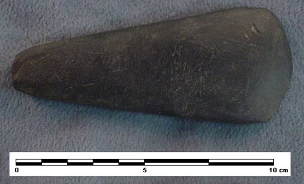
Figure 7. Cannel coal celt from Structure 2.
Turning to the ceramic data, 29 of 39 vessels associated with the floor of Structure 2 could be assigned to a vessel form/function. Vessel morphology consisted of salt pans (28 percent; n = 8), jars (21 percent; n = 6), bottles (21 percent; n = 6), plates (14 percent; n = 4), bowls (10 percent; n = 3), and miniature pots (7 percent; n = 2). In terms of number of vessels, the count from Structure 2 is comparable to household assemblages calculated for other non-Tinsley Hill phase Mississippian households in the region (Pauketat 1987:1–15, 1989:295–298; Smith and Moore 1994:202–203). Some variation exists, however. For example, the Structure 2 assemblage has a much lower percentage of jars when viewed alongside the Lohman and Stirling phase structures of the American Bottom ( Pauketat 1987:1–15, 1989:295–298). Likewise, the vessel assemblage from Structure 2 and that from the Brandywine Pointe site in Tennessee have a large percentage of salt pans (Smith and Moore 1994:202–203), while such vessel forms are missing in the American Bottom. Presently, it remains unclear whether the variation is a result of chronological or geographic differences, or perhaps a difference in the activities that were performed within the household.
If jars primarily represent cooking vessels as suggested by the presence of sooting while bowls and plates functioned as serving ware, then the serving to cooking ratio at Chestnut Lake was 1.16. For comparative purposes, Wesler (2001:96–97) identified a serving to cooking ratio at Wickliffe (15BA4) of .38 for Early Wickliffe (cal A.D. 1100–1175), .45 for Middle Wickliffe (cal A.D. 1175–1250), and .80 for Late Wickliffe (cal A.D. 1250–1350). If bottles are added to the serving category and pans to the cooking category, then the ratio is .75 for Chestnut Lake. These data indicate that the household pottery assemblage for Structure 2 included a range of vessel functions and that serving ware was as important as cooking wares. Pans, which tend to be wide and shallow, have traditionally been viewed as salt pans that were used to reduce brine during salt production (Muller 1986:226–228). While salt springs are located throughout the region, the Chestnut Lake site does not appear to be near one. Given their size and weight, these vessels could not be easily transported to a spring either. As argued by Smith and Moore (1994:202–203), some consideration must be given to the idea that not all pans functioned as salt pans and that other functions, possibly related to cooking, must also be considered.
Ceramic data also provided information on the spatial distribution of vessels within Structure 2. Vessel form appears to be non-randomly distributed, although the behavioral implication of this pattern remains unclear. As presented earlier, the north and east walls were likely locations for a raised sleeping platform. Within or immediately adjacent to this area, 20 of the 39 vessels noted above were located. In other words, 51 percent of the vessels were located in only 33 percent of the total floor area. Two possible interrelated interpretations are presented. First, fragments of broken pots located along walls, especially under a raised sleeping platform, may have been inadvertently missed during routine cleaning (as was the case with larger size lithic material). Alternatively, pots may have been stored on or under the platform. In either case, the central portion of the house contained relatively few sherds and most of those were small-sized and for that reason may have been overlooked during periodic cleaning (i.e., became part of the soil matrix through trampling). Also located on the structure floor under the bench were two ceramic ear plugs and a ceramic ear spool.
In summary, based on data recovered from the intact floor, numerous activities occurred in Structure 2. The centralized hearths indicate that heating and cooking activities took place within the structure, but the lack of storage pits inside or outside indicates that subterranean storage was not practiced or perhaps needed. A raised platform along the north and east walls likely functioned as a sleeping and/or storage area. Size-sorting of the lithic and ceramic material indicates that the larger-sized debris was found along the north wall, under the raised platform, while the central areas near the hearths were fairly clear of large-sized objects. This means that routine cleaning of the high traffic areas was practiced. Flotation samples from the floor near the hearths indicate that the processing of goosefoot and to a lesser extent maize occurred in this area.
A range of lithic activities from tool production and maintenance to hide and antler working is indicated by the debitage. Serving, storage (likely dry and liquid), and cooking vessels were found associated with the floor of Structure 2, suggesting all three activities occurred within the house. If orifice diameter is a rough indicator of vessel size, then the bowls were small (18–20 cm in diameter). The jars, which ranged between 14 and 40 cm in diameter, represented small to large vessels. The two salt pan rims that were measureable both had orifice diameters of 50 cm each. Given these sizes, most of the vessels were small or medium and conform to the needs of a household supporting a limited number of individuals. The range in jar size likely indicates that several size categories were manufactured.
The serving wares like bowls, plates, and bottles were found mainly along the east wall while jars were mainly in the southeast corner of the structure. Both of these areas may have been good places to store these vessels, either on or below the raised platform. Lastly, these data strongly point to a fall or winter occupation as indicated by goosefoot (Seeman and Wilson 1984:199–316) and the fact that lithic reduction activities in the house are normally conducted outdoor and away from high traffic living areas.
Household Occupants
Based on artifacts it appears that the occupants who lived and worked within and adjacent to Structure 2 conducted routine activities normally associated with Mississippian households. In all likelihood, these individuals were representative of the average Mississippian, but there are some clues within the assemblage that suggest some of them may have had a higher status or were able to acquire high status goods. The presence of two cannel celts is a prime example. The soft raw material they were fashioned from rendered them purely decorative or symbolic. To the best of our knowledge, other known cannel coal celts are rare in the region. The assemblage also contained galena, non-local cherts, and two ceramic ear plugs and a ceramic ring (or ear spool) which could be construed as status markers (Figure 8). Lastly, the high number of serving ware may also be reflective of a higher status household (Wesler 2001:96–97).
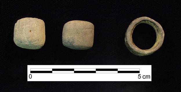
Figure 8. Ceramic personal ornaments.
Chestnut Lake in Regional Perspective
While other Tinsley Hill phase structures have been identified, few have been investigated in sufficient detail to provide comparative data to Chestnut Lake. For example, numerous Tinsley Hill phase structures were present at the Tinsley Hill site (Clay 1979, 1997:19–20), but only minimal data, such as general size and shape, is available. The Kincaid site (Butler 1991:271; Butler and Welch 2005:147–148; Cole et al. 1951:29–103), which is only located 3.5 miles northeast of Chestnut Lake, also has a very large Tinsley Hill occupation with numerous associated structures, but detailed architectural data are simply not available in published reports.
Based on the data from Chestnut Lake, we propose the following reconstruction of activities that occurred within and immediately adjacent to the Tinsley Hill phase house (Structure 2). We offer this interpretation not because we believe it is uniform across all houses of this time period, but merely to direct future researchers’ attention to the possibility that detailed analysis of Mississippian household activities can provide an abundance of data in a similar manner advocated by Wilk and Netting (1984) for ethnographic researchers.
Drawing in the data presented above, the main activity area within Structure 2 was in the central portion of the house in and around the hearths. This area was used for cooking and generally kept clean of large-sized refuse. Analysis of carbonized remains taken from across the structure floor indicates that cooking activities mainly centered on the processing of goosefoot and maize. Most of the jars and perhaps the salt pans were used in the cooking of these foodstuffs. The large jars may have also functioned as water jugs or for the storage of food. Along the east wall was a raised wooden platform that functioned as a sleeping area and possibly as storage for some of the larger-sized household utensils, like the salt pans. Mechanical stripping and magnemeter survey revealed no pits adjacent to the house. No evidence of underground storage was noted in or outside the structure either, so storage may not have been primary activity at the site (although storage above ground is a possibility).
Taking a broader perspective, the Late Mississippian in the lower Ohio valley, including the Tinsley Hill phase, was a time of substantial social and political transitions. As noted by Clay (1997), the lower Ohio witnessed a fundamental change after A.D. 1300 in which existing Mississippian systems and communities began to re-organize. New mound construction began to decline if not largely stopped by this time and the first appearance of large stone box cemeteries is documented. The change in mound construction and mortuary patterns also seems to be correlated with decreases in status differentiation, the abandonment of some older communities, and the development of new villages (Clay 1997:28–30). As pointed out by Clay, examples of this evolving political landscape include such sites as Wickliffe and Twin Mounds. At Wickliffe, the cemetery falls into disuse approximately cal A.D. 1250, while the habitation areas continue to be occupied until approximately cal A.D. 1350 (Matternes 1995; Wesler 2001). Twin Mounds, on the other hand, did not develop until after cal A.D. 1250 and is thought to date as late as cal A.D. 1450 (Kreisa 1995:140–171).
Importantly for Chestnut Lake, the changing political landscape is also evident at the nearby Kincaid site. New mound construction had largely ceased at the beginning of the Tinsley Hill phase (Butler 1991:271; Cobb and Butler 2002:627–629). A substantial residential population was present although it appears the site area contracted somewhat. The first stone box graves, some placed on mound tops, appear at this time and reflect changing attitudes on mortuary behavior and mound use at the site (Cobb and Butler 2002:627). Both Clay (1997:26) and Butler (1991:271) note that while Kincaid has a large Late Mississippian population, smaller outlying communities are largely absent at this time. This is especially the case in the Black Bottom where none of the smaller sites date after A.D. 1300 (Butler 1991:271). Clay suggested the Tinsley Hill occupation at Kincaid was the result of outlying communities moving into the mound center. Butler, however, noted that Late Mississippian habitation areas do not expand much at Kincaid at this time, so the near lack of outlying communities does not necessarily translate into those populations moving to Kincaid. Cobb and Butler (2002:629; 2006:328–350) proposed that some of those populations may have moved from the lower Ohio valley into the interior hill country of southern Illinois and established new settlements starting in the late 1200s or early 1300s, including Millstone Bluff, Hayes Creek, and Dillow’s Ridge.
As best as we can understand the data, the Chestnut Lake site, as viewed through the radiocarbon dates and ceramics of Structure 2, begins during the Tinsley Hill phase, around cal A.D. 1300. Based on the distribution of artifacts, the site may have encompassed an area approximately 1.6 ha in size, but probably somewhat less. If true, then Chestnut Lake probably consisted of numerous Tinsley Hill phase houses comprising a small community or hamlet. Since no evidence was recovered to indicate an earlier Mississippian occupation, it is very likely that its development started approximately cal A.D. 1300 and had to do with the same regional transformations espoused by Clay. Although only one site, the presence of Chestnut Lake only 3.5 miles from Kincaid stands in contrast to assertions by Butler and Clay that Mississippian sites are largely absent surrounding the mound center during the late Mississippian. Based on the artifact assemblage, it is possible that some of the individuals associated with Structure 2 had a higher status, or were able to acquire high status goods. If Clay is correct and the late Mississippian marked a relaxation in the strict political and economic structure of Mississippian society, then the expanded access to high status or valued goods may be another marker of that deconstruction.
Summary
Excavations at the Chestnut Lake site provided an opportunity to examine a rebuilt Mississippian house. The original building, Structure 1, was of wall trench construction and square-shaped, encompassing approximately 19 sq m. For whatever reason, Structure 2 replaced the original building. It also had wall trenches and a square-shape, but was slightly larger at 20 sq m. This structure burned leaving the floor intact, a condition in which it remained until our investigations. Several features were defined within Structure 2. These consist of: superimposed centralized hearths, a subterranean pit, a raised wooden platform, and internal posts. Based on subsistence remains and lithic data, Structure 2 was occupied during fall or perhaps winter.
Based on ceramic artifacts and radiocarbon dates, the site dates between cal AD 1300–1450 and as such encompasses the Tinsley Hill phase. Only a portion of the site was excavated and it is thought that additional structures are present at the site. A main activity area was identified within the structure and associated with a centralized hearth. Based on refuse disposal patterns, it appears that this area was mostly kept clean. No features were identified outside the structure. Food items prepared within the structure were dominated by goosefoot and maize. A raised wooden platform was likely present along the east wall. This platform may have functioned as a sleeping or storage area. The presence of cannel coal celts, galena, non-local cherts, and ceramic ear plugs suggest a high status family occupied the structure.
Given the intact floor of Structure 2, the excavations at Chestnut Lake provided an opportunity to reconstruct activities that occurred in a Late Mississippian house within the lower Ohio valley. While numerous houses have been identified and excavated in the region dating to this timeframe, relatively few had intact floors. The lack of floor integrity in these previous excavations limited researchers in their interpretations of past household activities. As shown at Chestnut, a great deal of useful information can be gleaned from intact floors. Contributions ranged from a better understanding of the organization of household activities at Chestnut Lake to the interpretative value of such sites within the larger political landscape of shifting polities and chiefdom cycling. It is hoped that future researchers will continue to explore the potential that household studies can have on our understanding of Mississippian social and political organization.
Acknowledgments:
These excavations were carried out at the request of, and funded by, the Kentucky Transportation Cabinet in conjunction with the proposed bridge replacement project of U.S. 60 over the Tennessee River. We would like to thank Berle Clay for providing comments on a draft of this paper and to Brian G. DelCastello and Derek Wingfield for helping with many of the articles illustrations and maps. Any errors or shortcomings are our responsibility.
References
Asch, Nancy B. and David L. Asch
1981 Archeobotany of Newbridge, Carlin and Weitzer Sites – The White Hall Components. Appendix B. In Faunal Exploitation and Resource Selection: Early Late Woodland Subsistence in the Lower Illinois Valley, by Bonnie Whatley Styles, pp. 275–291. Northwestern University Archeological Program Scientific Papers, Number 3. Evanston, Illinois.
Binford, Lewis R.
1983 In Pursuit of the Past. Thames and Hudson, London.
Bonzani, Renee M.
2002a Botanical Analysis. In A National Register Evaluation of Sites 15Mm137, 15Mm139, and 15Mm140 and Deep Testing Along Sycamore Creek in Montgomery County, Kentucky, by Michael D. Richmond, pp. 84–91. Contract Publication Series 01–106. Cultural Resource Analysts, Lexington, Kentucky.
2002b Botanical Analysis. In Early and Middle Archaic Archaeology at the Hart Site (15La183) in Lawrence County, Kentucky, by Jonathan P. Kerr. Ms. on file, Cultural Resource Analysts, Lexington, Kentucky.
2003 Paleoethnobotanical Analysis. In Phase II National Register Evaluation of 15Lv222 (The Chestnut Lake Site) and 15Lv223 (The Crounse Site) in Livingston County, Kentucky (Item No. 1-1115.00), by Richard L. Herndon, pp. 58–64. Contract Publication Series 03–32. Lexington, KY
Butler, Brian M., J. M. Penney, and C. A. Robison
1981 Archaeological Survey and Evaluation for the Shawnee 200 MW A.F.B.C. Plant, McCracken County, Kentucky. Research Paper No. 21. Center for Archaeological Investigations, Southern Illinois University, Carbondale, Illinois.
Butler, Brian M.
1991 Kincaid Revisited: The Mississippian Sequence in the Lower Ohio Valley. In Cahokia and the Hinterlands: Middle Mississippian Cultures of the Midwest, edited by T.E. Emerson and R.B. Lewis, pp.264–273. University of Illinois Press, Urbana.
Butler, Brian M. and Paul D. Welch
2005 Mounds Lost and Found: New Research at the Kincaid Site. Illinois Archaeology 17: 138–153.
Chapman, Jefferson and Andrea Brewer Shea
1981 Archaeobotanical Record: Early Archaic Period to Contact in the Lower Little Tennessee River Valley. Tennessee Anthropologist VI (1): 61–84.
Chapman, Jefferson, Robert B. Stewart, and Richard A. Yarnell.
1974 Archaeological Evidence for Precolumbian Introduction of Portulaca oleracea and Mollugo verticillata into Eastern North America. Economic Botany 28: 411–412.
Clay, R. Berle
1963a Tinsley Hill Village, 1962. Ms. on file, Office of State Archaeology, University of Kentucky, Lexington.
1963b The Tinsley Hill Mound. Ms. on file, Office of State Archaeology, University of Kentucky, Lexington.
1979 A Mississippian Ceramic Sequence from Western Kentucky. Tennessee Anthropologist 4:111–128.
1997 The Mississippian Succession on the Lower Ohio. Southeastern Archaeology 16:16–32.
2003 Geophysical Survey. In Phase II National Register Evaluation of 15Lv222 (The Chestnut Lake Site) and 15Lv223 (The Crounse Site) in Livingston County, Kentucky (Item No. 1-1115.00), by Richard L. Herndon, pp. 74–79. Contract Publication Series 03–32. Lexington, KY
Cobb, Charles R. and Brian M. Butler
2002 The Vacant Quarter Revisited: Late Mississippian Abandonment of the Lower Ohio Valley. American Antiquity 67: 625–641.
Cobb, Charles R. and Brian M. Butler
2006 Mississippian Migrations and Emplacement in the Lower Ohio Valley. In Leadership and Polity in Mississippian Society, edited by Brian M. Butler and Paul D. Welch, pp.328–350. Occasional Paper No. 33. Center for Archaeological Investigations, Southern Illinois University, Carbondale.
Cole, Faye-Copper, Robert Bell, John Bennett, Joseph Caldwell, Ned Emerson, Richard MacNeish, Kenneth Orr, and Robert Willis
1951 Kincaid: A Prehistoric Illinois Metropolis. University of Chicago Press, Chicago.
Edging, Richard
2001 Chapter 16: Archaeobotany at the Confluence. In Excavations at Wickliffe Mounds, edited by Kit W. Wesler. Located on accompanying CD-ROM. The University of Alabama Press, Tuscaloosa.
Edging, Richard B., and Sandra L. Dunavan
1986 Botantical Remains. In Mississippian Towns of the Western Kentucky Border, edited by R. Barry Lewis, pp. 87–98. The Kentucky Heritage Council.
Hally, David J.
1983 Use Alteration of Pottery Vessel Surfaces: An Important Source of Evidence for the Identification of Vessel Function. North American Archaeologist 4:1–25.
1986 The Identification of Vessel Function: A Case Study from Northwest Georgia. American Antiquity 51:267–295.
Kreisa, Paul P.
1991 Mississippian Sites in the Lower Ohio River Valley in Kentucky. Western Kentucky Project Report No. 9. Department of Anthropology, University of Illinois, Urbana-Champaign.
1995 Mississippian Secondary Centers along the Lower Ohio River Valley: An Overview of Some Socioplotical Considerations. In Current Archaeological Research in Kentucky: Volume Three, edited by John F. Doershuk et al., pp. 161–177. The Kentucky Heritage Council, Frankfort.
Lewis, R. Barry (editor)
1986 Mississippian Towns of the Western Kentucky Border: The Adams, Wickliffe, and Sassafras Ridge Sites. Kentucky Heritage Council, Frankfort.
Lewis, R. Barry and Lynne M. Mackin
1984 The Adams Site Ceramic Assemblage in Regional Perspective. In, Late Prehistoric Research in Kentucky, edited by David Pollack, Charles D. Hockensmith and Thomas Sanders, pp. 187–204. The Kentucky Heritage Council, Frankfort.
Lofgren, Orvar
1974 Family and Household among Scandinavian Peasants: An Exploratory Essay. Ethnologia Scandinavica 74:1–52.
Lopinot, Neal H.
1997 Cahokian Food Production Reconsidered. In Cahokia: Domination and Ideology in the Mississippian World, edited by Timothy R. Pauketat, and Thomas E. Emerson, pp. 52–68. University of Nebraska Press, Lincoln.
Matternes, Hugh B.
1995 Mound C and the Mississippian Decline: A View of Culture Preserved in Wickliffe’s Mortality Data. In Current Archaeological Research in Kentucky: Volume Three, edited by John F. Doershuk et al., pp. 179–203.
Medick, H.
1976 The Proto-Industrial Family Economy: The Structural Function of the Household during the Transition from Peasant Society to Industrial Capitalism. Social History 3:291–315.
Moerman, Daniel E.
1998 Native American Ethnobotany. Timber Press, Portland, Oregon.
Muller, Jon
1986 Archeology of the Lower Ohio River Valley. Academic Press, New York.
1997 Mississippian Political Economy. Plenum, New York.
Munson, Patrick J.
1984 Comments on Some Additional Species, with Summary of Seasonality. In Experiments and Observations on Aboriginal Wild Plant Food Utilization in Eastern North America, edited by P. J. Munson, pp. 459–473. Prehistory Research Series Vol. 6, No. 2. Indiana Historical Society, Indianapolis.
1987 Expedient Core Technology and Sedentism. In The Organization of Core Technology edited by Jay K. Johnson and Carol A. Morrow, pp. 285–304. Westview Special Studies in Archaeological Research, Boulder Colorado.
Pauketat, Timothy R.
1987 A Functional Consideration of a Mississippian Domestic Vessel Assemblage. Southeastern Archaeology 6:1–15.
1989 Monitoring Mississippian Homestead Occupation Span and Economy using Ceramic Refuse. American Antiquity 54:288–310.
Phillips, James M.
2001 Architectural Remains at Wickliffe (15BA4): A Middle Mississippian House in Western Kentucky. Wickliffe Mounds Research Report Number Eight. Murray State University. Wickliffe Mounds Research Center. Wickliffe, Kentucky.
Phillips, Philip
1970 Archaeological Survey in the Lower Yazoo Basin, Mississippi, 1949–1955. Papers of the Peabody Museum of Archaeology and Ethnology Vol. 60, No. 1&2. Harvard University, Cambridge, Massachusetts.
Phillips, Philip, James A. Ford, and James B. Griffin
1951 Archaeological Survey in the Lower Mississippi Alluvial Valley, 1940–1947. Papers of the Peabody Museum of Archaeology and Ethnology Vol. 25. Harvard University, Cambridge, Massachusetts.
Pollack, David, and Jimmy A. Railey
1987 The Chambers (15ML109): An Upland Mississippian Village in Western Kentucky. Kentucky Heritage Council.
Pollack, David, and Eric Schlarb
2008 Canton (15Tr1): Investigation of a Mississippian Platform Mound? Paper presented at the Twenty-Fifth Annual Kentucky Heritage Council Archaeological Conference, Highland Heights, Kentucky.
Riordan, Robert V.
1975 Ceramics and Chronology: Mississippian Settlement in the Black Bottom, Southern Illinois. Ph.D. dissertation, University of Michigan, Ann Arbor. University Microfilms, Ann Arbor.
Rogers, J. Daniel
1995 The Archaeological Analysis of Domestic Organization. In Mississippian Communities and Households, edited by J. Daniel Rogers and Bruce D. Smith, pp. 7–31. The University of Alabama Press, Tuscaloosa, Alabama.
Rolingson, M. A., and D. W. Schwartz
1966 Late Paleo-Indian and Early Archaic Manifestations in Western Kentucky. Studies in Anthropology No. 3. University of Kentucky Press, Lexington.
Rossen, Jack, and James Olson
1983 The Controlled Carbonization and Archaeological Analysis of SE U.S. Wood Charcoals. Journal of Field Archaeology 12:445–456.
Seeman, Mark F. and Hugh D. Wilson
1984 The Food Potential of Chenopodium for the Prehistoric Midwest. In Experiments and Observations on Aboriginal Wild Plant Food Utilization in Eastern North America, edited by Patrick J. Munson, pp. 299–316. Prehistory Research Series Vol. 6, No. 2. Indiana Historical Society, Indianapolis.
Smith, Kevin E., and Michael C. Moore
1994 Excavation of a Mississippian Farmstead at the Brandywine Pointe Site (40DV247), Cumberland River Valley, Tennessee. Midcontinental Journal of Archaeology 19:198–222.
1991 Beyond the Formation of Hearth-Associated Artifact Assemblages. In The Interpretation of Archaeological Spatial Patterning, edited by Ellen M. Kroll and T. Douglas Price, pp. 269–296. Plenum Press, New York.
Stuiver, Minze, Paula J. Reimer, Edouard Bard, J. Warren Beck, G. S. Burr, Konrad A. Hughen, Bernd Kromer, Gerry McCormac, Johannes van der Plicht, and Marco Spurk
1998 INTCAL98 Radiocarbon Age Calibration, 24,000-0 cal BP. Radiocarbon 40(3):1041–1083.
1991 Generalized Core Technology and Tool Use: A Mississippian Example. Journal of Field Archaeology 18:363–375.
Webb, William S.
1952 The Jonathan Creek Village, Site 4, Marshall County, Kentucky. Reports on Anthropology Vol. VIII, No. 1. Department of Anthropology and Archaeology, University of Kentucky, Lexington.
Welch, Paul D. and Margaret Scarry
1995 Status-Related Variation in Foodways in the Moundville Chiefdom. American Antiquity 60:397–420.
Wesler, Kit W.
2001 Excavations at Wickliffe Mounds. University of Alabama Press, Tuscaloosa.
2006 Platforms As Chiefs: Comparing Mound Sequences in Western Kentucky. In Leadership and Polity in Mississippian Society, edited by Brian M. Butler and Paul D. Welch, pp.142–155. Occasional Paper No. 33. Center for Archaeological Investigations, Southern Illinois University, Carbondale.
Wilk, Richard R. and Robert McC Netting
1984 Households: Changing Forms and Functions. In Households: Comparative and Historical Studies of the Domestic Group, edited by Robert McC Netting, Richard Wilk, and E.J. Arnold, pp. 1–28. University of California Press, Berkeley.
Yarnell, Richard A.
1986 A Survey of Prehistoric Crop Plants in Eastern North America. The Missouri Archaeologist 47:47–59.
Young, James A. and Cheryl G. Young
1992 Seeds of Woody Plants in North America. Dioscorides Press, Portland, Oregon.
Editor’s note: This paper was accepted after Tier II review (see Author’s Guidelines).