A Shovel Testing Survey of the Canton Site (15Tr1), Trigg County, Kentucky
Andrew P. Bradbury and Richard L. Herndon
Abstract
During a survey conducted for the Kentucky Transportation Cabinet, the Canton Site (15Tr1) was revisited. The site is a major Mississippian site with mounds located on the Cumberland River in Trigg County. The current investigations were to the south of the mound area and resulted in the identification of a minor Late Woodland occupation along with the better known Mississippian occupation. The ceramic assemblage was composed almost entirely of shell-tempered Mississippian sherds, with small amounts of grog-tempered Late Woodland sherds. The chipped stone tool assemblage was dominated by locally occurring St. Louis and Warsaw cherts. This paper provides a summary of the investigations and analysis of the recovered materials that will then be used to re-evaluate existing interpretations of the site.
As part of a recent archaeological survey project conducted in conjunction with a Kentucky Transportation Cabinet (KYTC) project, a portion of the Canton Site (15Tr1) was systematically shovel tested by archaeologists from Cultural Resource Analysts, Inc. (CRA) (Bradbury 2006). Little professional work has been conducted at the site, though the site is listed as an important Mississippian site in the Kentucky State Plan (Lewis 1990:394; Pollack 2008). Based on previous work at Canton, the site represents a large residential site including a mound complex. Mississippian and minor Late Woodland components are known from the site. The majority of the site is likely Mississippian in age as are the mounds. The portion of the site within the project area contained some areas of intact deposits or features and was located to the south of the mound area. While much of the site appears to have been disturbed, several areas with intact deposits or features exist at the site. This paper summarizes the results of the shovel test survey and integrates previous information concerning the site.
Background Information
The Canton site is situated on top of the bluff overlooking the Cumberland River floodplain which is now inundated as Lake Barkley (Figure 1). The site has been known since the 1800s when Rafinesque (1833) prepared a map of the site and it is briefly mentioned by Webb and Funkhouser (1932:376) in their survey of archaeological sites in Kentucky. Murray State University conducted a survey at the site in 1979 and documented a Woodland and Mississippian complex of at least four mounds dating between A.D. 600 and 1400 (data obtained from OSA Site Files 1979). Stout et al. (1996) discuss the excavation of nine test units at the site and provide background information. The work by Stout et al. (1996) is the only previous professional investigation of the site reported. Their work focused on the area around the mounds to the north of the current project area. A site map of the mound area is also included in that publication. Modern houses, churches, and a paved parking lot now occupy portions of the site in the mound area. In fact, two of the churches and a trailer are situated on top of mounds.
Most of what is known about the site comes from the work conducted by Stout et al. (1996). They note that some of the earth works first identified by Rafinesque are still visible, while others are not. For example, none of the fortification contours originally defined for the site was visible at the time Stout et al. worked at the site. Several of the mounds have been destroyed and others modified. Human remains were reported to have been removed from one of the mounds, probably by pothunters (Stout et al. 1996:268). In 2007, Pollack and Schlarb (2008) examined the purported location of Mound 3, but found no evidence to suggest that a mound had once been present in this area. However, they (Pollack and Schlarb 2008; also see Pollack 2008:635) documented a wall-trench structure measuring 4.2 by 3.6 m. This structure had been set in a shallow basin and had a central hearth. A portion of a basin-shaped wall trench structure that had been rebuilt at least once also was documented, as were a minimum of three additional structures, a large central post, and a large trash pit. Stout et al. (1996:274) suggest that the area to the south of the mounds may contain more useful data as this portion of the site may be undisturbed. This southern area was investigated during the current survey and is the focus of this paper.
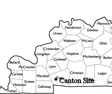
Figure 1. Location of the Canton site.
Survey Methods and Results
The current investigations focused on the area of the site situated to the south of the main mounds shown on the map produced by Stout et al. (1996). Shovel testing at the site was conducted using several different intervals (Figure 2). The initial four transects were excavated on a 10-m grid pattern. Through the initial shovel tests it was determined that much of the site area had been disturbed, mostly likely due to bulldozing (borrow for the existing U.S. 68/KY 80 road construction?). The majority of the topsoil appears to have been removed from these areas. In these shovel tests, a strong brown (7.5YR 4/6) or yellowish red (5YR 4/6) silty clay subsoil (sterile) was encountered within 10 cm of ground surface. Due to the disturbed nature of the site, the next seven shovel test transects were excavated at 20-m intervals. Two areas of potentially undisturbed deposits or possibly features were identified through the initial shovel tests. In these areas, deeper soils were identified. In some cases, shovel tests were excavated as deep as 80 cm. Prehistoric materials were recovered from these shovel tests. In areas that appeared to contain intact deposits, additional investigations were conducted with shovel tests on a 5-m grid. A total of 104 screened shovel tests were excavated within the portions of the site within the project area. Of these, 48 were positive for cultural material. All fill from shovel tests was visually inspected and screened through .25 inch mesh.
The first area containing intact soils was situated at the northern edge of the project area within a tree line. Here, intact soils were encountered along an old fence line. Soils in this area were generally a dark brown (10YR 3/2) silt loam to approximately 5 cm below surface underlain by a dark yellowish brown (10YR 4/4) clay loam to 40-70 cm and a strong brown (7.5YR 4/6) silty clay subsoil. Artifacts were recovered throughout the upper 70 cm of the deposit. The soils in this area of the site may represent the original ground surface and are undisturbed, possibly never plowed.
The second area of deeper deposits was encountered in shovel tests along Transects 9, 10, 11, and 12 in the area of Shovel Test 6. This area is situated in the northwestern portion of the project area on the edge of the bluff overlooking the Cumberland River (now Lake Barkley). For example, Transect 12, Shovel Test 2 was excavated to a depth of 80 cm below surface. The profile of Shovel Test 2 indicated a very dark grayish brown, organic (10YR 3/2, humus) layer from 0-12 cm below surface. From 12-44 cm, a dark yellowish brown (10YR 3/4) silty clay loam was encountered. Finally, from 44-80 cm a dark brown (7.5YR 3/2) sandy clay loam was encountered. Cultural materials were recovered from all three of these strata (168 artifacts) and included flakes, ceramics, burnt clay, and faunal materials. Other shovel tests in this area generally encountered sterile subsoil by 30 cm below ground surface, though artifact density was generally high in these shovel tests (20+ artifacts).
{Figure 2 redacted to protect site location and
landowner confidentiality}
Figure 2. Schematic plan map of work conducted at Canton Site by CRA.
Artifact Analyses
Materials recovered from the current survey of the Canton Site consisted of both historic and prehistoric artifacts. Only a light density of historic materials was recovered. The prehistoric materials are the focus of the following sections.
Artifact Distribution
As a first step in the analyses, artifact density maps were constructed for each of the artifact classes represented from shovel testing at the site. For the examination of lithic artifacts, all flakes larger than .25 inch were used (Figure 3). Based on the distribution of flakes, three high density areas can be identified at the site: Area A; Area B; and Area C. A light scatter of flakes was recovered from shovel tests in other areas of the site.
The distribution of thermal shatter (lithic artifacts thermally damaged to the point that they can no longer be identified as anything other than thermally damaged chert) across the site indicates two main areas for this artifact class (Figure 4). These correspond to Areas A and B from the flake distribution. Area A appears to have the highest concentration of thermal shatter suggesting the presence of hearths or other sources of fire in this area.
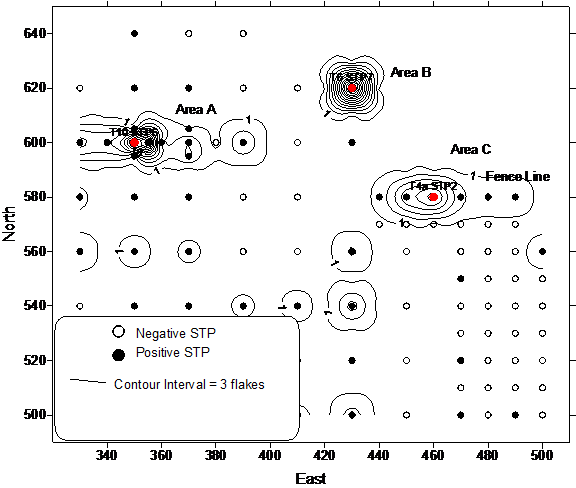 Figure 3. Flake density map based on shovel testing at Canton. |
 Figure 4. Distribution of thermal shatter at Canton. |
Most of the ceramic assemblage was recovered from shovel tests located just south of the Canton site mounds. The majority of the ceramics were recovered from two areas within the project boundaries (Figure 5). These correspond to Area A and Area B noted in the flake distribution. The latter area was identified through shovel testing on Transect 10 around Shovel Test 6. Soils in this shovel test were much deeper (approximately 70 cm deep) and contained an abundance of prehistoric ceramics. Area B from the lithic analysis also showed a relatively higher density of ceramics.
As can be seen in Figure 5, both Area A and Area B produced Late Woodland and Mississippian sherds. In other words, there does not appear to be any spatial differences between the Late Woodland and Mississippian occupations. One possible exception to this generalization is that the Mississippian sherds may be slightly more dispersed than the Late Woodland sherds. It is also interesting to note that the burned clay and daub also appear to overlap the distribution of the sherds. The presence of daub and burned clay in a constricted area as seen in the artifact distribution map may indicate the presence of a buried Late Woodland or, more likely, Mississippian structure in Area A.
Bone and shell were predominately recovered from different areas of Canton (Figure 6). Bone was only recovered from Area A. The majority of the mussel shell was recovered from a single shovel test (Transect 6, STP 7) in area B. Both prehistoric and historic materials were recovered from this area of the site making it difficult to determine whether this material is associated with the prehistoric or historic occupation of the site. The distribution of bone overlaps with other prehistoric materials (e.g., ceramics and lithics) and for this reason is likely associated with the prehistoric occupation.
 Figure 5. Density map illustrating the location and frequency of Late Woodland sherds, Mississippian sherds, and burned clay/daub at Canton. |
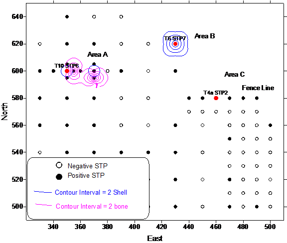 Figure 6. Distribution of faunal material at Canton. |
The above sections indicate three main areas of high artifact density: Area A; Area B. and Area C. Area C is situated along an old fence line at the northern boundary of the CRA survey area. An approximately one meter high berm of dirt existed at this location. This berm may represent the original land surface before the area was bulldozed. Area B is represented by Transect 6 Shovel Test 7, just to the north and west of Area A. A high density of materials was recovered from this test within a tree line. Area A is situated towards the northwestern edge of the survey area within a wooded area. Area A was identified through shovel testing on Transect 10 around Shovel Test 6. Soils in this shovel test were much deeper (approximately 70 cm deep) and contained an abundance of prehistoric ceramics, lithics, and faunal material. The remainder of the site within the project area was represented by a light scatter of artifacts.
Faunal Materials
A limited amount of faunal material was recovered during the survey. These materials consisted of mussel shell fragments (n = 16) and animal bone (n = 29). These materials are summarized by provenience in Table 1. These materials were simply quantified and were not separated by genus, species, etc.
Table 1. Faunal materials recovered from Canton Site.
|
Unit |
Bone |
Mussel Shell |
|
T10STP6 |
0 |
2 |
|
T12STP2 |
12 |
0 |
|
T4aSTP2 |
1 |
0 |
|
T5STP5 |
0 |
1 |
|
T6STP7 |
1 |
10 |
|
T8STP6 |
0 |
1 |
|
T9STP6 |
1 |
2 |
|
T9STP6a |
14 |
0 |
|
Totals |
29 |
16 |
Ceramic Analysis
Given the importance of relating the current assemblage to previous investigations at the Canton Site (Stout et al. 1996) and for comparisons to other nearby Mississippian sites in the region, the current analysis employed the type-variety classification framework established by Phillips et al. (1951) and modified by Phillips (1970). Later researchers in western Kentucky have expanded the use of the type-variety system in the area (e.g., Clay 1979; Lewis and Mackin 1984; Pollack and Railey 1987; and Wesler 2001).
As shown in Table 2, a total of 260 ceramic objects were recovered during the current investigations at Canton. This consisted of: 221 sherd fragments; 37 pieces of burned clay; and 2 pieces of daub. The entire sherd sample was subsequently size sorted. The smaller than 2 cm size faction (sherdlets) consisted of 143 pieces, representing about 55 percent of the total sherd collection. These small-sized remains were counted, weighed, and identified by temper type, but not otherwise included in the analysis. The remaining 78 sherds (45 percent of the assemblage) measured larger than 2 cm in maximum diameter each and included five rims. Based on temper type, surface treatment, and surface decoration, it was determined that of the 221 sherds (including the 143 sherdlets) that approximately 83.3 percent (N=184) were Mississippian, while the remaining 16.7 percent (N=37) were Late Woodland (Table 3).
Table 2. Tabulation of ceramic material at Canton by count and weight.
|
Type of Ceramic Material |
Counts |
Weight (g) |
|
Sherdlets |
143 |
122.7 |
|
Body and Rim Sherds |
78 |
334.2 |
|
Burned Clay |
37 |
28.1 |
|
Daub |
2 |
48.1 |
|
Total |
260 |
533.1 |
Table 3. Tabulation of ceramic type at Canton by count and weight.
|
Ceramic Typology and Cultural Components |
Counts |
Weight (g) |
|
Late Woodland Period |
|
|
|
Sherdlets (Grog) |
24 |
18.8 |
|
Baytown Plain |
7 |
30.9 |
|
Mulberry Creek Cord marked |
6 |
26.1 |
|
Mississippian Period |
|
|
|
Sherdlets (Shell) |
119 |
103.9 |
|
Mississippi Plain |
44 |
208.1 |
|
Bell Plain |
5 |
11.7 |
|
Kimmswick Fabric Marked |
4 |
14.2 |
|
Matthews Incised var. Manly |
1 |
1.5 |
|
Untyped - Mississippian |
11 |
41.7 |
|
Total |
221 |
456.9 |
The Late Woodland Ceramic Assemblage
The Late Woodland ceramic assemblage consisted of 24 grog tempered sherdlets and 13 grog tempered sherds larger than 2 cm in maximum diameter. Of the latter sherds, seven had a plain exterior and six, including a rim, had cord marked exteriors. The sherds with grog tempering and plain exteriors were classified as Baytown Plain (Figure 7). Their cord-marked counterparts were classified as Mulberry Creek Cord-marked. Both of these types were originally defined by Phillips et al. (1951). While grog as a primary tempering agent is known from Early and Middle Woodland contexts in the region (Butler and Jefferies 1986; Phillips et al. 1951), the thin walls of the Canton sherds argues against them relating to these earlier time periods.
A cautionary note by Clay (1991:142–157) and Wesler (1991:58, 67-68) directs our attention to the possibility that some of the grog-tempered sherds may be Mississippian in origin and not Late Woodland. Although far from clear, Early Mississippian pottery in some parts of western Kentucky may have been grog-tempered, but have incorrectly been grouped within the Late Woodland ceramic sequence. If true, then some of the grog-tempered pottery from Canton could be Mississippian. Further work at Canton from intact deposits could help address this possibility.
The Mississippian Period Ceramic Assemblage
The Mississippian ceramic assemblage consisted of 119 sherdlets and 65 sherds larger than 2 cm in maximum diameter. The latter sherds included 44 Mississippi Plain sherds, five Bell Plain sherds, four Kimmswick Fabric Marked sherds, one Matthew Incised var. Manly sherd, and 11 Mississippian sherds that could not be typed (Figure 8).
 Figure 7. Representative sample of Baytown Plain (A; Transect 9, STP 6a) and Mulberry Creek Cord-marked (B and C; Transect 12, STP 2) sherds from 15Tr1. |
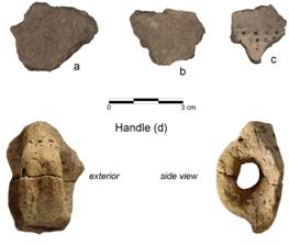 Figure 8. Examples of Kimmswick Fabric Marked sherds (A and B; Transect 12, STP 2), Matthews Incised var. Manly sherd (C; Transect 9, STP 6a), and a Mississippian Plain handle (D; Transect 9, STP 6a) from 15Tr1. |
Burned Clay and Daub
During the course of excavations, approximately 37 pieces of burned clay were recovered. The burned clay fragments did not contain any evidence of wattle impressions and were generally small-sized. In addition to the burned clay, there were also 2 pieces of daub. Daub was identified by the presence of stick impressions on its surface. The identification of daub may indicate the presence of a buried structure, possibly Late Woodland or Mississippian, in the immediate area.
Synopsis of the Canton Site Ceramic Assemblage
The ceramic assemblage from Canton was composed almost entirely of shell-tempered Mississippian sherds, with small amounts of Late Woodland sherds. Mississippian ceramics from the site included Mississippi Plain, Bell Plain, Kimmswick Fabric Marked, Matthews Incised var. Manly, and a few unclassified shell tempered sherds. One complete Mississippi Plain handle was also recovered during the investigations that likely belonged to a globular jar. Both Hilgeman (2000:129) and Wesler (2001:97-98) would classify this handle as wide-intermediate based on its middle thickness to middle width ratio. The Late Woodland component at the site is represented by Baytown Plain and Mulberry Creek Cord-marked sherds.
Lithic Analysis
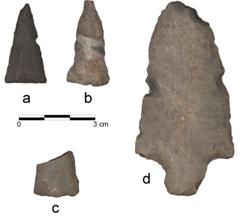
Lithic artifacts recovered from Canton consisted of 281 flakes larger than .25 inch, 128 flakes smaller than .25 inch, 21 thermal shatter, two (113.7 g) cores, three bifaces (67.0 g), four (35.4 g) hafted bifaces, and one drill (9.2 g). Three of the hafted bifaces were of the Small Triangular cluster (Justice 1987), the other was an Early Woodland Stemmed cluster (Figure 9). All of the hafted bifaces were found in the northeastern part of the site along an old fence line.
The area surrounding the Canton Site could be considered raw material rich as a number of chert bearing formations (notably St. Louis and Warsaw) are located within the surrounding area. Samples of chert from the Lower St. Louis formation were collected by the first author during the current survey along an upland ridge at sites 15Tr202 and 15Tr400, several miles south of the Canton Site. Both sites were quarries at the location of St. Louis chert outcrops. The chert was commonly found at the edges of the ridgeline right where the steep contours began. This chert varied from coarse to fine grained. Colors ranged from very pale orange (10YR 8/2 on the Munsell rock chart) to moderate yellowish brown (10YR 5/4). Banding was common as was lighter mottling. Nodules varied in size, but were generally quite large (1-2 kg). A thick, chalky cortex was common on the nodules. Once the chalky cortex was removed, the chert proved to be of good knapping quality.
Samples of Warsaw chert were collected from the project area eroding out of the bluff below Canton. These samples were generally a medium to coarse grained chert and gray-brown in color with mottles. Inclusions consist of macrofossils and are common. Macroscopically, the samples collected below Canton resemble samples collected by the first author at the Dover quarries in Stewart County, Tennessee, near the town of Dover. Large prehistoric quarries are located at that location and the chert was widely traded during the Mississippian period (Gramly 1992). Given the similarity of these materials, chert recovered from Canton that resembled Dover chert was classified as Warsaw though it is recognized that both local and non-local sources of this material may have been used at the site. Knapping quality of the local Warsaw chert was comparable to Dover chert.
Aggregate trend analysis (Bradbury and Carr 2004) was used as a means of classifying the flake debris. In short, aggregate trend analysis combines aspects of mass analysis (e.g., Ahler 1989a, 1989b; Ahler and Christenson 1983) and stage analysis (e.g., Magne 1985). Like mass analysis, aggregate trend analysis examines batches of flakes rather than examining attributes of individual flakes. The mass analysis trends are: percent by count of flakes in the .25 inch size grade and the average weight of flakes in the .25 inch size grade (e.g., Ahler and Christenson 1983). The other variables examined are: percentage of blocky debris and percentage of flakes with two or more facets. In short, as reduction continues, the percentage of flakes in the .25 inch size grade increases, the average weight of flakes in the .25 inch size grade decreases, the percentage of blocky debris decreases, and there is an increase in the percentage of flakes with two or more facets.
St. Louis chert dominated the flake debris; with Warsaw chert being relatively well represented (Table 4). Only a few flakes of other materials (Ste. Genevieve, Salvisa, and chalcedony) were represented. Both of the cores were of St. Louis chert. Six of the modified implements were of St. Louis. Two modified implements (both Small Triangular cluster) were of Warsaw chert. As noted above, Warsaw chert can be procured from the bluff below the site. St. Louis chert can be procured from sources in close proximity to the site. Ste. Genevieve chert can be procured from areas to the north of the site and can be considered a local source. Chalcedony can be procured from several local formations. Salvisa chert is known from Ordovician formations in the Salt and Dix River drainages in west-central Kentucky (Gatus 1980). Salvisa chert is macroscopically indistinguishable from the Ordovician aged Bigby Cannon chert. Sources of this chert are in the Eastern Outer Nashville Basin Area of Tennessee (Amick 1987:38). Regardless of the exact area of procurement, this chert can be considered an exotic source.
Table 4. Flake debris by raw material.
|
Material |
Count |
Percent |
|
St. Louis |
171 |
60.9% |
|
Ste. Genevieve |
4 |
1.4% |
|
Local |
2 |
0.7% |
|
Salvisa |
1 |
0.4% |
|
Warsaw |
102 |
36.3% |
|
Chalcedony |
1 |
0.4% |
|
Total |
281 |
100.0% |
Flakes were separated by the three areas noted in the artifact distribution section above and summed by raw material to identify possible differences in chert use between the areas. Due to sample sizes, only St. Louis and Warsaw cherts were examined. The mass analysis classification functions and aggregate trends were calculated for the two raw materials by area. Though some of the sample sizes are border line, differences between the raw materials, and minor differences between areas are seen (Table 5). All of the St. Louis samples are classified as biface edging by mass analysis. The Warsaw samples from Areas A and B are classified as core reduction, and Area C is classified as biface edging. The aggregate trends results are similar, although some tool production is indicated for the Warsaw from Areas A and B and varying amounts of core reduction are indicated for St. Louis from all three areas and Warsaw chert from Area C.
Table 5. Results of aggregate and mass analysis for 15Tr1 data.
|
Area |
Raw Material |
Total Count |
Mass Classification |
Percent 2+ facets |
Percent Blocky |
Ave Weight .25 inch |
Percent Count .25 inch |
Suggested Activity |
|
A |
Warsaw |
23 |
Core Reduction |
4.35% |
8.70% |
0.729 |
60.87% |
Core Reduction with some tool production |
|
B |
Warsaw |
20 |
Core Reduction |
5.00% |
15.00% |
0.777 |
65.00% |
Core Reduction with some tool production |
|
C |
Warsaw |
38 |
Biface Edging |
10.53% |
7.89% |
0.634 |
84.21% |
Biface Edging with some core reduction |
|
A |
St. Louis |
83 |
Biface Edging |
19.28% |
2.41% |
0.637 |
87.95% |
Biface Edging/thinning with minor core reduction |
|
B |
St. Louis |
26 |
Biface Edging |
7.69% |
7.69% |
0.65 |
69.23% |
Biface Edging with some core reduction |
|
C |
St. Louis |
22 |
Biface Edging |
13.64% |
9.09% |
0.628 |
81.82% |
Biface Edging with minor core reduction |
Two cores, both of St. Louis chert, were recovered from Canton. One was a tested cobble, the other a multidirectional core.
Modified implements consisted of three bifaces, one drill, and four hafted bifaces. Two of the hafted bifaces, both Small Triangular clusters, were of Warsaw chert. The remaining tools were of St. Louis chert. Of the bifaces, two were final stage (class 204-4.1) and one was late stage (204-3.1). Three of the hafted bifaces were Small Triangular clusters. One of these appeared to be a triangular point that was broken during manufacture (see Figure 5-7). The other hafted biface was an Early Woodland Stemmed cluster. It is unclear whether the latter hafted biface represents an earlier occupation of the site or the reuse of an earlier tool by Late Woodland/Mississippian people. No additional artifacts (e.g., lithic or ceramic) dating to the Early Woodland sub-period were recovered from the site.
Two of the Small Triangular points were recovered from Transect 6 STP 7 (Area B). The third Small Triangular was from Area A. One of the cores was from Area C. One of the final stage bifaces (class 204-4.1) and a core were recovered from general shovel tests (i.e., not associated with the areas noted above). The remaining tools and core were recovered from Area A.
Discussion
The ceramic assemblage from the Canton Site was composed almost entirely of shell-tempered Mississippian sherds. Only a minor amount of Late Woodland sherds was recovered. Both the Mississippian and Late Woodland ceramics were recovered from the same areas of the site (see Figure 5). Mississippian ceramics from the site included Mississippi Plain, Bell Plain, Kimmswick Fabric Marked, Matthews Incised var. Manly, and a few unclassified shell tempered sherds. One complete Mississippi Plain handle was also recovered. The handle, classified as wide-intermediate based on its middle thickness to middle width ratio, likely belonged to a globular jar. Baytown Plain and Mulberry Creek Cord-marked sherds represent a Late Woodland component at the site. The average wall thickness of these sherds (6.8 to 7.7 mm) suggests that the Late Woodland occupation was not particularly early or late. Both the Baytown Plain and Mulberry Creek Cord-marked sherds were identified by Stout et al. (1996) during their excavations on the northern portion of the site.
Ceramic analysis associated with the current investigations of the Mississippian component at Canton confirmed interpretations made by other researchers. Stout et al. (1996) and Pollack and Schlarb (2008) identified many of the same ceramic types. These data point to the main Mississippian occupation between cal. A.D. 1150-1300. This time frame corresponds to the middle portion of the Mississippian period. The middle Mississippian has been variously labeled Angelly, Kincaid, and Middle/Late Wickliffe (Butler 1991, Clay 1997, Wesler 2001). A strap handle exhibiting a groove that extended down its entire length was also recovered. Based on its middle thickness to middle width ratio (.43), this handle would be classified as wide-intermediate. Hilgeman (2000:129) and Wesler (2001:97-98) suggest a date range from A.D. 1200 to 1350 for such handles. The chronological position of the handle confirms to the date previously given.
Given the nature of the site (large, Mississippian, mounds), the lithic assemblage was somewhat small and limited in tool classes present: drill (n=1), bifaces (n=3), hafted bifaces (n=4), and cores (n=2). One of the hafted bifaces was an Early Woodland Stemmed cluster suggesting a possible earlier occupation at the site, or the reuse of older tools by Late Woodland or Mississippian people. Given the lack of other Early Woodland materials (i.e., ceramics), the latter hypothesis may be more likely. The three remaining hafted bifaces were of the Small Triangular cluster. One of these appeared to have been broken during manufacture. Of the bifacial implements, one was late stage (exhibited soft hammer percussion scars, was shaped, and thinned), the remainder were final stage (exhibited soft hammer percussion and pressure flaking scars, was shaped, and thinned). Materials at the site were predominantly recovered from the three main areas noted above. The chipped stone tool assemblage was dominated by locally occurring St. Louis and Warsaw cherts. The latter chert can be procured directly from bedrock formations from the bluff face below the site. This material (Warsaw) is macroscopically similar to Dover chert from Tennessee. Flake debris of Warsaw chert was predominantly the result of core reduction activities and lesser amounts of tool production. Conversely, a higher percentage of the St. Louis chert was the result of tool production with lesser amounts of core reduction.
A limited amount of faunal materials was recovered from Canton. These materials consisted of mussel shell fragments (n = 16) and animal bone (n = 29). Bone was recovered from Area C at the site. Mussel shell was recovered from Areas B and C. The latter area is dominated by prehistoric materials while the former area contains both historic and prehistoric materials. The bone from Area C was recovered from shovel tests that contained relatively high amounts of ceramic and lithic artifacts. In addition, these tests were deeper than the surrounding tests. It is possible that the tests containing most of the bone represent features at the site.
No clearly definable features were observed during the investigation of the site; however, potentially intact deposits or features were located in several areas of the site. In addition, portions of the site appear to have been disturbed. This conclusion is indicated by the shallow soils (less than 10 cm thick), the presence of red clay subsoil immediately below the humus layer or mixed with the surface soils. Few artifacts were recovered from this area of the site. Disturbances in this area may be the result of bulldozing in association with borrowing for the original U.S. 68/80 construction.
Deeper deposits were documented in shovel tests on Transects 9, 10, 11, and 12 (Area C). These deeper deposits are possibly features. This area of the site is in the northwestern portion of the project area. This area is wooded and situated towards the bluff edge. In several of these shovel tests deeper soils were encountered. These deeper soils may be features. Shovel tests 5 m from these deep deposits revealed much shallower soils (less than 30 cm in depth). For example, Transect 12 Shovel Zest 1 was excavated to 80 cm while 10 m to the west, Transect 10 Shovel Test 6 was excavated to 23 cm.
Materials recovered from the deeper shovel tests included faunal materials, mussel shell, burnt clay, and several large (larger than 2 cm in diameter) ceramics. The latter included the looped handle noted above.
Summary
Early and Late Woodland and Mississippian diagnostics were recovered from the Canton Site. The Early Woodland material consisted of one Early Woodland Stemmed cluster hafted biface. No Early Woodland ceramics were recovered. The Early Woodland biface may represent the reuse of earlier material by the Late Woodland or Mississippian people. Definite Late Woodland materials consisted of ceramics (Baytown Plain and Mulberry Creek Cord-marked sherds). Mississippian ceramics from the site included Mississippi Plain, Bell Plain, Kimmswick Fabric Marked, Matthews Incised var. Manly, and a few unclassified shell tempered sherds. Based on the ceramic analysis, the Mississippian component of the site was the most intensive occupation.
Acknowledgments
Funding for the survey of the Canton Site was provided by the Kentucky Transportation Cabinet (Item No. 1-180.00) in conjunction with the widening of U.S. 68/KY 80, Canton to Cadiz Bypass Reconstruction project. After completion of the survey, the KYTC modified the construction plans to avoid intact areas of the site.
References Cited
Ahler, Stanley A.
1989a Experimental Knapping With KRF and Midcontinent Cherts: Overview and Applications. In Experiments in Lithic Technology, edited by D.S. Amick and R. P. Mauldin, pp. 67-99. BAR International Series 528.
1989b Mass Analysis of Flaking Debris: Studying the Forest Rather Than the Tree. In Alternative Approaches to Lithic Analysis, edited by D. O. Henry and G. H. Odell, pp. 85-118. Archaeological Papers of the American Anthropological Association Number 1.
Ahler, Stanley A. and Robert C. Christenson
1983 A Pilot Study of Knife River Flint Procurement and Reduction at Site 32DU508, a Quarry and Workshop Location in Dunn County, North Dakota. Department of Anthropology and Archeology, University of North Dakota, Grand Forks. Submitted to State Historical Society of North Dakota, Bismarck, Contract No. YA553-CT1-1089. Copies available from State Historical Society of North Dakota, Bismarck.
1987 Lithic Raw Material Variability in the Central Duck River Basin: Reflections of Middle and Late Archaic Organizational Strategies. TVA publications in Anthropology 50. Norris, Tennessee.
Bradbury, Andrew P.
2006 Additional Archaeological Survey for Bike Trails, Temporary Easements, and Additional Right-of-way, U.S. 68/KY 80 in Trigg County, Kentucky (Item No. 1-180.00). Contract Publication Series 06-106, Cultural Resource Analysts, Inc., Lexington, Kentucky.
Bradbury, Andrew P. and Philip J. Carr
2004 Combining Aggregate and Individual Methods of Flake Debris Analysis: Aggregate Trend Analysis. North American Archaeologist 25(1) 65-90.
Butler, Brian M.
1991 Kincaid Revisited: The Mississippian Sequence in the Lower Ohio Valley, In Cahokia in the Hinterlands, edited by Thomas E. Emerson and R. Barry Lewis, pp. 264–273. University of Illinois Press, Urbana.
Butler, Brian M. and Richard W. Jefferies
1986 Crab Orchard and Early Woodland Cultures in the Middle South. In Early Woodland Archeology, edited by Kenneth B. Farnsworth and Thomas E. Emerson, pp. 523–534. Center for American Archeology. Kampsville Seminars in Archeology No. 2. Cneter for American Archeology Press. Kampsville.
Clay, R. Berle.
1979 A Mississippian Ceramic Sequence from Western Kentucky. Tennessee Anthropologist 4:111-128.
1991 Summary and Conclusions. In Excavations at the Andalex Village (15HK22), Hopkins County, Kentucky, edited by Charles M. Niquette, pp. 142–163. Contract Publication Series 91–03. Cultural Resource Analysts, Inc.
1997 The Mississippian Succession on the Lower Ohio. Southeastern Archaeology 16:16–32
Gatus, Thomas
1980 Appendix C; Chert Descriptions, In Taylorsville Lake, Kentucky, Archaeological Resources Survey and Evaluation, Season II. Archaeological Report 24, University of Kentucky, Department of Anthropology.
Gramly, Richard M.
1992 Prehistoric lithic industry at Dover, Tennessee. Persimmon Press, Buffalo, New York.
Hilgeman, Sherri L.
2000 Pottery and Chronology at Angel. The University of Alabama Press, Tuscaloosa.
Justice, Noel D.
1987 Stone Age Spear and Arrow Points of the Midcontinental and Eastern United States. Indiana University Press, Bloomington.
Lewis, R. Barry and Lynne M. Mackin
1984 The Adams Site Ceramic Assemblage in Regional Perspective. In, Late Prehistoric Research in Kentucky, edited by David Pollack, Charles D. Hockensmith and Thomas Sanders, pp. 187-204. The Kentucky Heritage Council, Frankfort.
Lewis, R. Barry
1990 Mississippi Period. In The Archaeology of Kentucky: Past Accomplishments and Future Directions. State Historic Preservation Comprehensive Plan Report No. 1, edited by David Pollack, pp. 375-466. Kentucky Heritage Council, Frankfort.
Magne, Martin P. R.
1985 Lithics and Livelihood: Stone Tool Technologies of Central and Southern Interior B. C. Archaeology Survey of Canada, Mercury Series 133. Ottawa, Ontario.
Phillips, Philip
1970 Archaeological Survey in the Lower Yazoo Basin, Mississippi, 1947-1955. 2 vols. Peabody Museum of Archaeology and Ethnology Papers 60. Harvard university, Cambridge, Massachusetts.
Phillips, Philips, James A. Ford, and James B. Griffin
1951 Archaeological Survey in the Lower Mississippi Alluvial Valley, 1949-1955. Papers of the Peabody Museum 25. Harvard University, Cambridge, Massachusetts.
Pollack, David
2008 Mississippi Period. In The Archaeology of Kentucky: An Update, Vol. 2, edited by David Pollack, pp. 605–738. State Historic Preservation Comprehensive Plan Report No. 3. Kentucky Heritage Council, Frankfort.
Pollack, David, and Jimmy A. Railey
1987 The Chambers (15ML109): An Upland Mississippian Village in Western Kentucky. Kentucky Heritage Council.
Pollack, David, and Eric Schlarb
2008 Canton (15Tr1): Investigation of a Mississippian Platform Mound? Paper presented at the Twenty-Fifth Annual Kentucky Heritage Council Archaeological Conference, Highland Heights, Kentucky.
Rafinesque, Constantine S.
1833 Description d’une Ville Ancienne du Kentucky Occidental sur la Riviere Cumberland. Bulletin de la Societe de Geographie 20:236-241.
Stout, Charles, Gregory R. Walz, and Jarrod Burks
1996 Archaeological Investigations at the Canton Site (15Tr1), Trigg County, Kentucky. In Current Archaeological Research in Kentucky: Volume Four. Kentucky Heritage Council.
Webb, William S. and W. D. Funkhouser
1932 Archaeological Survey of Kentucky. University of Kentucky Reports in Archaeology and Anthropology 2.
Wesler, Kit W.
2001 Excavations at Wickliffe Mounds. University of Alabama Press, Tuscaloosa.