The Chief’s Yard: Spatial and Temporal Assemblage Dynamics at Wickliffe Mounds
Kit W. Wesler
Editor’s note: for the .pdf edition, this paper is presented in separate figure and text files so that a reader may follow the discussion and the associated figure by having both files open on the screen.
Abstract
Analyses of the Wickliffe Mounds site (15BA4; Wesler 2001) have been based on an overview of assemblage patterning through time, using a general catalogue of items (lithics, ceramics, ornaments, etc.) and a more detailed analysis of ceramics (type-variety, vessel form based on rims) presented as summary data in tabular format. Digitized data and mapping software now allow for a detailed spatial analysis of the assemblages in visual formats as well. Mapping of ceramic types and serving-to-cooking vessel ratios in middens highlights a particular area of the site, between Mound B, the platform which probably supported the elite dwelling, and Mound C, which became the focus of a cemetery in the middle period of the site’s occupation. I hypothesize that this area may be identifiable as a chief’s “yard”, that is, the location under immediate control of the chief’s household. Whether the area served merely as the midden for the elite residence, or whether it was a designated area for elite-led activities such as hosted food-related events, will require further analysis.
Introduction
The Wickliffe Mounds site (15BA4) has enjoyed or suffered attention from archaeologists for nearly a century. As techniques, technology, method and theory in archaeology have changed, so have the questions we ask of sites. Legacy data are not always adequate to answer modern questions, but if collections were recovered and recorded systematically, digitization and mapping software may encourage new insights from continuing analysis.
In this paper I explore ceramic data from excavations at Wickliffe Mounds in the 1980s through 2000s. Mapped on a new topographic base map coordinated from the same datum as the excavation grid, spatial distributions of ceramic wares and types provide perspectives on temporal trends noted in previous discussions (Wesler 2001), in which I suggested that the middle period of the site’s occupation saw the residence of a chief on the smaller platform mound, Mound B. I also suggested that the elite family used more serving vessels than the inhabitants of the rest of the village, and that other villagers followed this trend in the later occupation period. A tacit assumption in my analysis was that the dwelling on top of Mound B was the focus of the elite activities.
The spatial analysis presented here suggests a different scenario: that the area between Mounds B and C was the actual focus of activities. I introduce the concept of a “chief’s yard” to Wickliffe studies, an area where the elite members of the village hosted events. Conforming to previous interpretations, however, the chief’s yard is primarily a middle period phenomenon, with similar activities diffusing throughout the site in the later period. This analysis demonstrates the utility of fully analyzed and digitized assemblage data as compared to selected samples from a complex and long-lived village site.
The Wickliffe site
The Wickliffe Mounds site is located on the bluff of the Mississippi River in Ballard County, Kentucky. It was first mapped by Robert Loughridge (1888), a geologist, in the best rendering of the site before impact by 20th-century disturbances (Figure 1; mound designations added). In Loughridge’s map, there are two platform mounds (A and B) and a pair of mounds or a long, low, saddled mound (D) defining a central plaza, a set of smaller mounds surrounding the central precinct (C, E, G, H, I) and a mound and probable palisade line across the neck of the bluff. Loughridge missed a small mound in the brush on the west edge (F). Mounds A, B and C are still visible on the surface. Only small remnants of Mounds D and F survive. Mounds E, G, H, I and the palisade mound are not visible on the surface today, although excavations have verified Mound H (Wesler 2001).
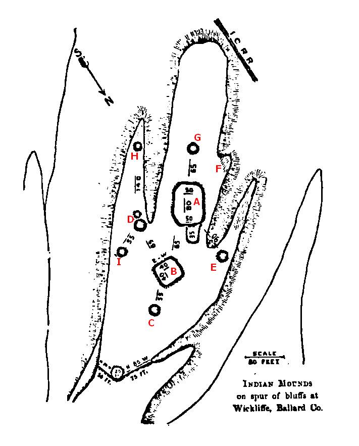
Figure 1. Loughridge map of Wickliffe Mounds with modern mound designations.
C. B. Moore visited the site in the early 20th century but found little to interest him (Morse and Morse 1998). In 1932 Fain W. King, a Paducah businessman, purchased the site in order to create a tourist attraction on the model of the Dickson Mounds excavations in Illinois. King enlisted the help of Walter B. Jones of the Alabama Museum of Natural History to begin excavations. Jones’s crew tested five mounds and then placed major excavations in the two platforms (Mounds A and B) and in the vicinity of a smaller mound (Mound C), which turned out to be a cemetery and which became the centerpiece of the tourist attraction. Jones withdrew by the end of 1932, and King completed the exposure of a large area of the cemetery with amateur excavators. In the mid-1930s, Fay-Cooper Cole of the University of Chicago, as a sort of spin-off of the Kincaid field school, sent graduate students to Wickliffe to try to add more systematic controls to the King excavations. The Chicago students introduced 5 x 5-ft gridded excavations with 1-foot vertical levels, and helped excavate Mounds D, on the east side of the plaza, E and F. King completed the Mound F excavations on his own in 1938-1939. Unfortunately no report was ever written, and only a few sketchy field notes from the Alabama project survive (Wesler 2001: Chapters 2, 3). The Chicago-aided excavation called Mound E does not appear to be where the original Mound E was, but may have been the area of the southern tip of the site (Wesler 2001).
After a small test excavation by the University of Illinois (Lewis 1986), in 1983 the site and collections were donated to Murray State University (MSU), which created the Wickliffe Mounds Research Center (WMRC) under my direction. Between 1984 and 2004, the WMRC conducted fifteen seasons of excavations on the site (Figure 2). At first the excavations targeted areas near the King excavations in order to investigate the contexts he had explored. Then a series of excavations documented the cemetery in preparation for removal of human remains from exhibit. The human remains were analyzed for a doctoral dissertation (Matternes 2000). The last few excavations explored areas of the site that had not been studied previously (Wesler 2001). The WMRC excavations were coordinated from a central datum.
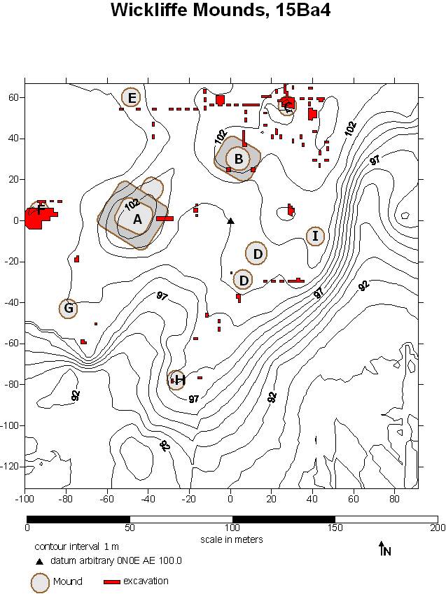
Figure 2. Wickliffe Mounds site showing mounds and excavations 1984-2004.
In 2004 the Wickliffe site was transferred to Kentucky State Parks, and became the Wickliffe Mounds State Historic Site (WMSHS). MSU continues to work with the park and the collections, and the WMSHS continues to curate the collections, which include the King artifacts (which represent mainly Mounds D, E and F, most of which bear systematic provenience labels by square and level), the 1983 U.I. collection, and the WMRC collections. All but the 1993 WMRC excavations have been catalogued and entered into a relational database. The databases as of 2001 were published on a CD-ROM in Wesler (2001). The human remains were reburied on-site in 2011 and 2012 by agreement between the WMSHS and the Chickasaw Nation, after re-inventory and digital photography of the entire collection.
A summarizing monograph (Wesler 2001) presented an overall interpretation of the development of the site. The occupation was divided into three periods based on 14C dates, ceramic chronology, and stratigraphic contexts. In the Early Wickliffe period (EWp), ca. AD 1100-1175, the inhabitants established a small village without mounds around a central plaza. The village area expanded during the Middle Wickliffe period (MWp), AD 1175-1250, as mound construction began. In the Late Wickliffe period (LWp), AD 1250-1350, the village spread over the entire area of the bluff, probably bounded on the upland side by the mound and palisade marked on the Loughridge (1888) map (but not visible now).
Mound B, the smaller platform on the north side of the plaza, contained middens on buried summits, suggesting that this was a residential mound. Buried summits in Mound A, the larger platform on the west side of the plaza, had clear indications of burned structures but no signs of middens, and probably was not residential. Therefore Mound B is interpreted as an elite residence.
My (Wesler 2001) previous analysis focused on two areas relevant to this discussion: temporal trends and indications of chiefly centralization. In terms of trends, Kreisa and McDowell (2001) noted that deer increased in proportion of the faunal assemblage through time, but portions with high and medium utility indices declined within the deer assemblage; turkey increased relative to waterfowl; and fish diminished as a proportion of the faunal assemblage over the three periods. Koldehoff and Carr (2001) saw an increasing use of northern cherts. My analysis of the ceramics showed a general increase in the serving-to-cooking vessel ratio, led in each period by the Mound B (elite residential) contexts.
Brown (2001) took an innovative, early GIS approach, using a spatial-statistical technique to study the general distribution of several artifact categories. She divided the debitage assemblages into two categories, those dominated by early-stage reduction (larger flakes) and those by medium-stage reduction (smaller flakes; the use of 1/4'” screens in the field meant that late-stage reduction flakes are poorly represented). The three Wickliffe periods showed different patterns of distribution, suggesting different organizing principles. It is worth emphasizing here that Brown’s analysis was highly generalized, while Kreisa and McDowell’s and Koldehoff and Carr’s analyses were based on a few samples selected for period representation.
A number of data suggest that the Middle Wickliffe period was a period of centralization (explored in Wesler 2001). Most of the stages of the platform mounds were constructed in the MWp. Mound D is tentatively identified as an elite burial mound begun in the MWp (Wesler 1996, 2006b). Mound C belongs to the MWp, and so does the cemetery surrounding it (implying that EWp and LWp cemeteries have yet to be discovered). Burlington chert, imported from the Missouri hinterland of Cahokia, is best represented in the MWp, as are stone tools, craft items, and personal items as proportions of the entire assemblage, and flake tools as a proportion of the lithic assemblage. Ramey Incised ceramics appear in the platform mounds. A higher utility index of deer and a higher serving-to-cooking vessel ratio characterize Mound B. The distribution of large flakes centers on Mound B in the MWp. The MWp assemblages show more diversity than either the EWp or LWp assemblages (Wesler 2006a).
In the LWp, the final caps were constructed on the platform mounds, which may not have had structures on top (between plowing and the King excavations, it is impossible to say). All of the MWp indicators dropped off. The serving-to-cooking vessel ratio continued to increase, but throughout the site. The site was abandoned at the end of the LWp, sometime around AD 1350.
These data accord well with a model in which the period of platform mound construction corresponds to the period when a chief is in residence (Hally 1996). In the MWp, a resident chief promoted mound building, lived on a platform mound overlooking the plaza, brought the cemetery into town, may have created an elite burial mound at the east side of the plaza, initiated a foodway that called for more serving vessels, and may have centralized the production or import of large flakes.
Current research on the Wickliffe Mounds data
Current Wickliffe research focuses on digital reconstruction of the landscape and detailed mapping of artifact distributions. The first step was to create a new topographic map using a total station. The previous topographic map (Wesler 2001:Fig. 1.2) was based on a map hand-drawn by Charles Stout (Lewis 1986:Fig.27) using elevation points measured with an optical (that is, non-electronic) transit. My attempt to overlay the WMRC excavation grid onto a photocopied version of the Stout map did not result in a very good fit (Wesler 2001:Figure 1.2), and the Brown (2001) GIS maps required a “rubbersheet” distortion of the digitized Stout map.
Figure 2 and subsequent figures of this paper utilize the new base map, prepared with a TopCon total station and the Surfer 8.06 (Golden Software 2006) software package. Figure 2 presents the topographic map, the WMRC excavation areas, and the locations of mounds as visible on the landscape (Mounds A, B, C, D, F), verified by excavation (all of the previous, plus Mound H), or approximated based on the Loughridge (1888) map (Mounds E, G, I). The topographic survey is not quite finished, lacking the base of the bluff on the west and northwest, but the occupation area is included. Comparison of Figure 1 with the previous map of Wickliffe excavations (Wesler 2001:Figure 1.2) demonstrates the improvement in accuracy.
Figure 3 depicts the distribution of middens identified as belonging to the EWp. The Early Wickliffe middens are mostly close to the top of the bluff, indicating a fairly small village surrounding a central plaza. From analysis so far, there were no mounds in the Early period, except possibly the first stage of Mound B at the end of the period.
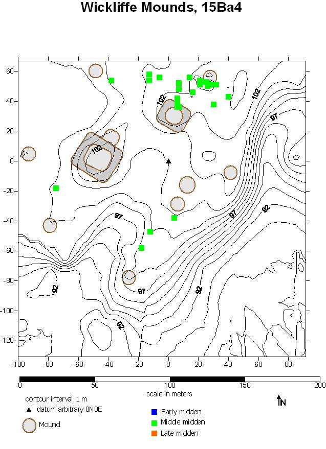
Middle Wickliffe middens spread out a bit farther, partly pushed back by the building of the platform mounds (Figure 4). As noted above, there are also indications that Mound C (which may have been a complex of three small mounds [Wesler 2001]) and the first stages of Mound D are MWp structures. It is also possible that the habitation area was expanding with increased population.
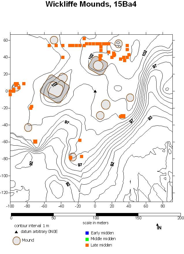
In the Late Wickliffe period, middens occur all over the bluff (Figure 5). It appears that the habitation area continued to expand until it reached the steeper slopes of the bluffs, except at the northeast, where the palisade bounded the village. The site was abandoned at the end of the LWp, sometime around AD 1350.
|
Figure 4. Distribution of Middle Wickliffe middens. |
Figure 5. Distribution of Late Wickliffe middens. |
Figure 3. Distribution of Early Wickliffe middens. |

Figures 3-5 provide visual confirmation of conclusions reached previously (Wesler 2001). Similar maps could have been (and in manuscript, were) constructed by hand-coloring copies of the original excavations map as already published (Wesler 2001:Fig. 1.2). Because of the power of digitized catalogue and analytical data merged with computerized mapping techniques, however, spatial representation of different artifact types and ratios between artifact categories is now much more achievable. The present digital publishing format also makes full presentation of the maps feasible.
Mapping has concentrated so far on distributions of ceramics, because type-variety and rim form analysis of the entire catalogued collection has been completed, amounting to more than 181,000 sherds from 3474 provenience lots. Of the sherds, 52,174 were recovered from midden contexts by WMRC excavations, and can be mapped by excavation unit.
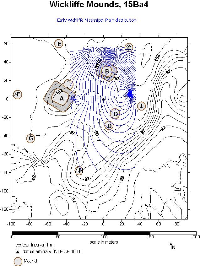
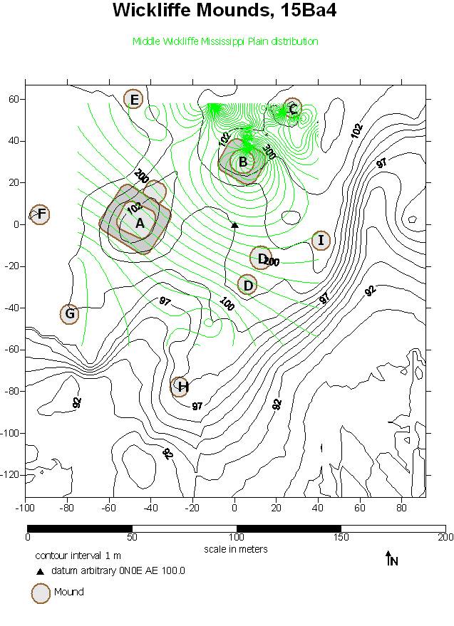
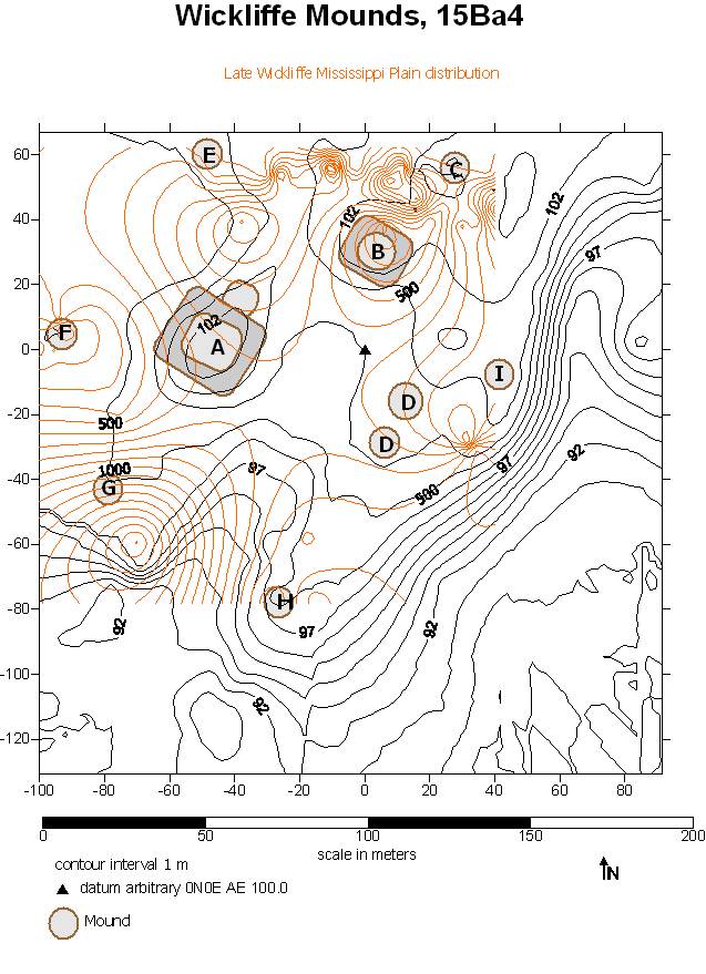
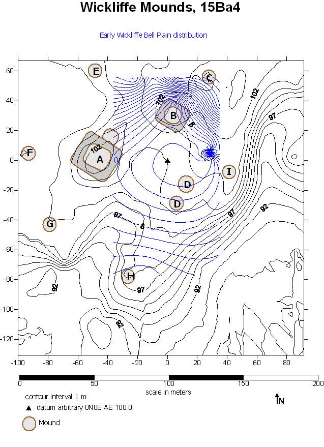
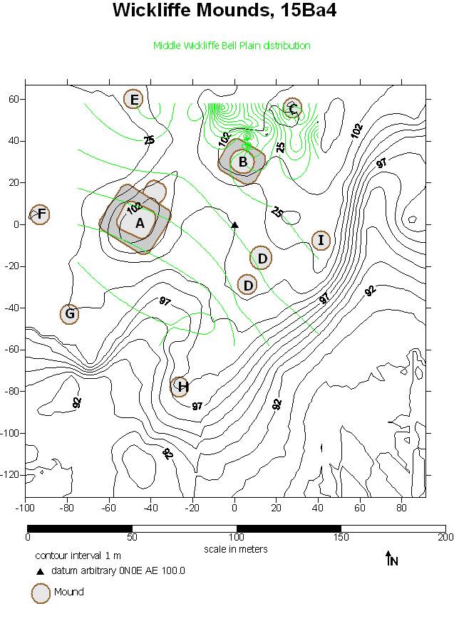
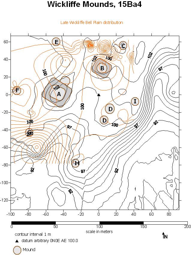
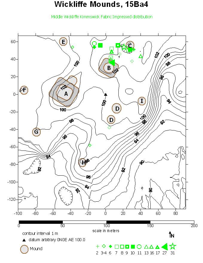
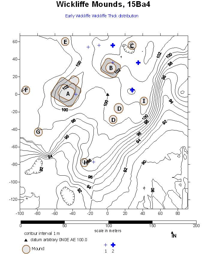
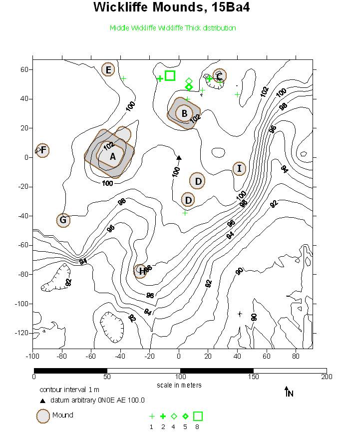
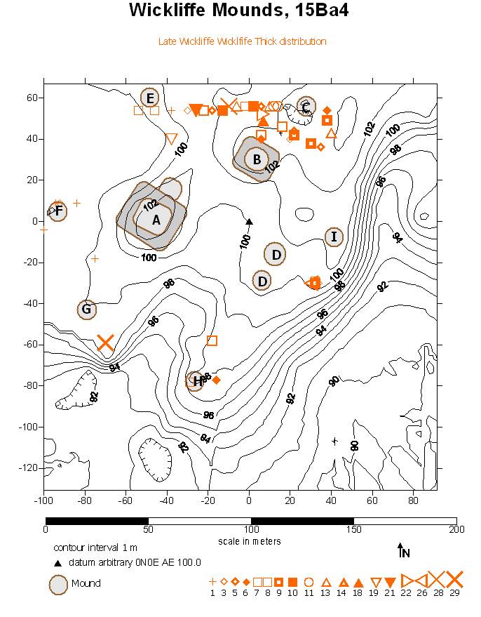
Mississippi Plain accounts for 42,912 (82%) of the midden sherds. Figure 6 presents the distribution of EWp Mississippi Plain sherds as a contour map. The distribution essentially matches the volume of midden—that is, more sherds come from the deeper middens. (An apparent tangle of contour lines northwest of Mound I is the result of several small excavation units in close proximity.) This is true for all three periods (Figures 6, 7, 8). It is also true of the distribution of the other plain ware, Bell Plain (6226 midden sherds, 12%; Figures 9-11), as well as the utility wares Kimmswick Fabric-Impressed (782 sherds, 1.5%: Figures 12-14) and Wickliffe Thick (446 sherds, 1%: Figures 15-17). Because of the smaller sample sizes, the latter two types are mapped as symbols instead of contours, the size, complexity and density of the symbol increasing with quantity. These maps show that Mississippi Plain, Bell Plain, Kimmswick Fabric Impressed and Wickliffe Thick wares were ubiquitous throughout the village and in all three periods. The block-like contour maps of each period also illustrate the increasing size of the village through time.
|
Figure 6. Distribution of Early Wickliffe Mississippi Plain ceramics. |
Figure 7. Distribution of Middle Wickliffe Mississippi Plain ceramics. |
Figure 8. Distribution of Late Wickliffe Mississippi Plain ceramics. |
|
Figure 9. Distribution of Early Wickliffe Bell Plain ceramics. |
Figure 10. Distribution of Middle Wickliffe Bell Plain ceramics. |
Figure 11. Distribution of Late Wickliffe Bell Plain ceramics. |
|
Figure 12. Distribution of Early Wickliffe Kimmswick Fabric Impressed ceramics. |
Figure 13. Distribution of Middle Wickliffe Kimmswick Fabric Impressed ceramics. |
Figure 14. Distribution of Late Wickliffe Kimmswick Fabric Impressed ceramics. |
|
Figure 15. Distribution of Early Wickliffe Wickliffe Thick ceramics. |
Figure 16. Distribution of Middle Wickliffe Wickliffe Thick ceramics |
Figure 17. Distribution of Late Wickliffe Wickliffe Thick ceramics. |


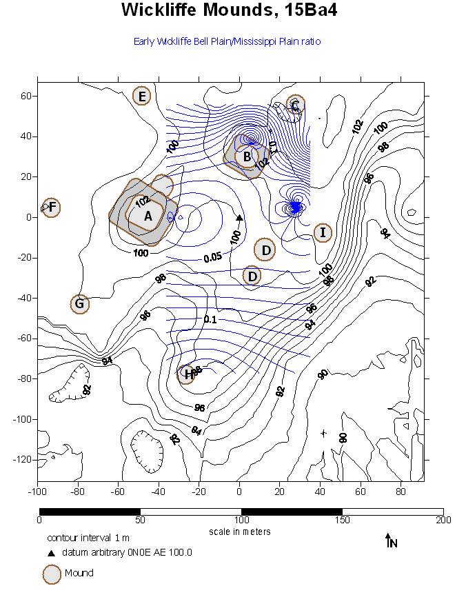
As noted above, previous analysis argued that a chief in the MWp introduced a higher serving-to-cooking vessel ratio, evidenced in the Mound B middens. Broadly speaking, Mississippi Plain sherds tend to belong to utilitarian vessels, and Bell Plain to serving vessels. This analysis designates jars, pans, and funnels as cooking/utilitarian vessels, and bowls, flare-rimmed bowls, plates, and bottles as serving vessels. There are Mississippi Plain plates, flare-rimmed bowls, bowls, and bottles and a very few Bell Plain jars, so the ware division is not completely discrete. However, mapping the ratio of Bell Plain to Mississippi Plain is a first-order approximation of the serving-to-cooking (s/c) ratio. The distribution map of the EWp ratios (Figure 18) suggests that the highest ratios are associated with the locations that became occupied by platform mounds, even though the mounds had not yet been constructed.
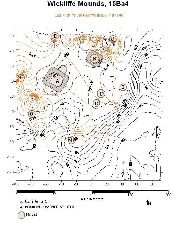
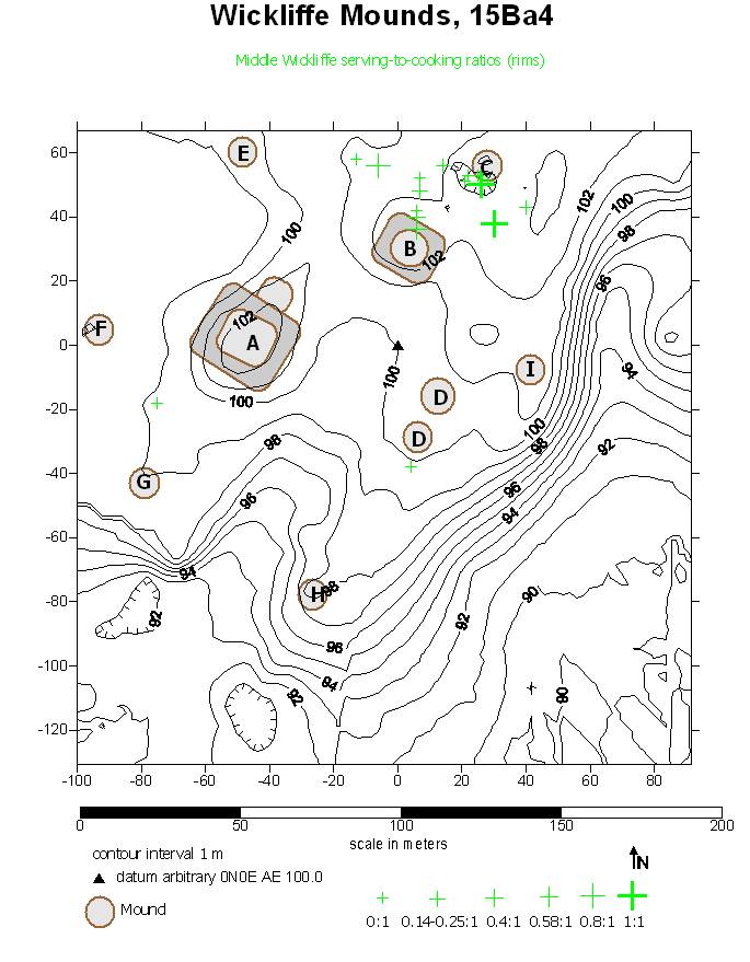
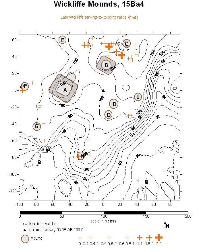
In the MWp, however, a concentration of higher Bell/Mississippi ratio emerges between Mounds B and C (Figure 19). In the LWp this concentration persists, but less prominently (Figure 20), and other areas of high ratios are distributed throughout the site.
|
Figure 18. Distribution of Early Wickliffe Bell Plain/Mississippi Plain ratios. |
Figure 19. Distribution of Middle Wickliffe Bell Plain/Mississippi Plain ratios. |
Figure 20. Distribution of Late Wickliffe Bell Plain/Mississippi Plain ratios. |

An alternative view of the serving-to-cooking ratio draws directly from vessel forms as interpreted from rim sherds. Because the numbers of identifiable rims are small, the following maps are presented using symbols rather than as contour maps. Figure 21 presents the distribution of s/c ratios of Early Wickliffe middens that produced rims. Symbol size increases with ratio. The highest ratios are in the northeast, in the Mounds B and C area. In the MWp, the higher ratios concentrate even more strongly in the Mounds B-C area (Figure 22). In the LWp, the highest ratios remains in the same area, but there are middens with middle-range ratios scattered across the site (Figure 23). These distributions complement the Bell/Mississippi Plain ratio distributions, and point to an area of interest between Mounds B and C, which is particularly highlighted during the MWp.
|
Figure 21. Distribution of Early Wickliffe serving/cooking vessel rim ratios. |
Figure 22. Distribution of Middle Wickliffe serving/cooking vessel rim ratios. |
Figure 23. Distribution of Late Wickliffe serving/cooking vessel rim ratios. |

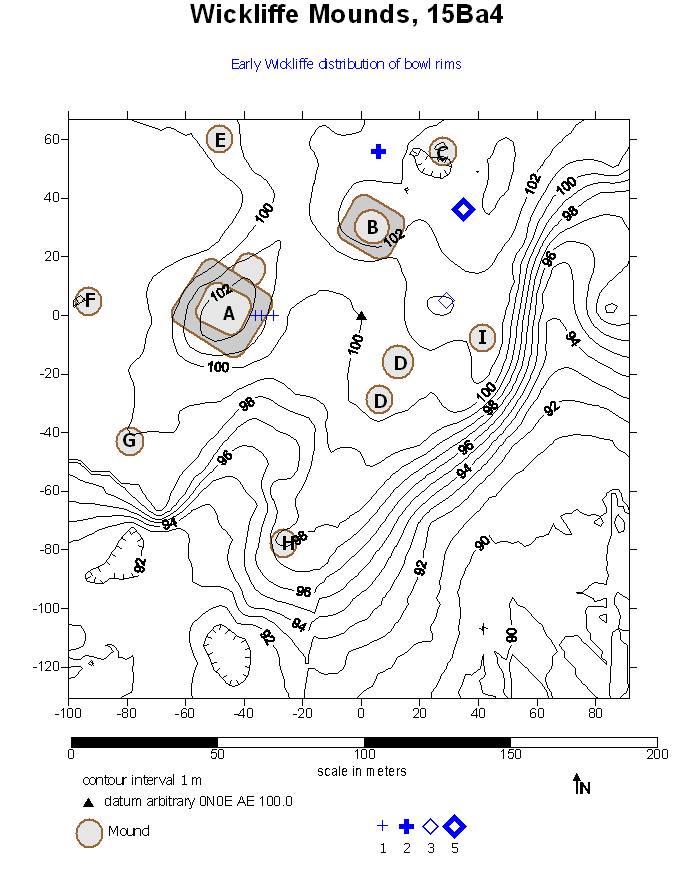
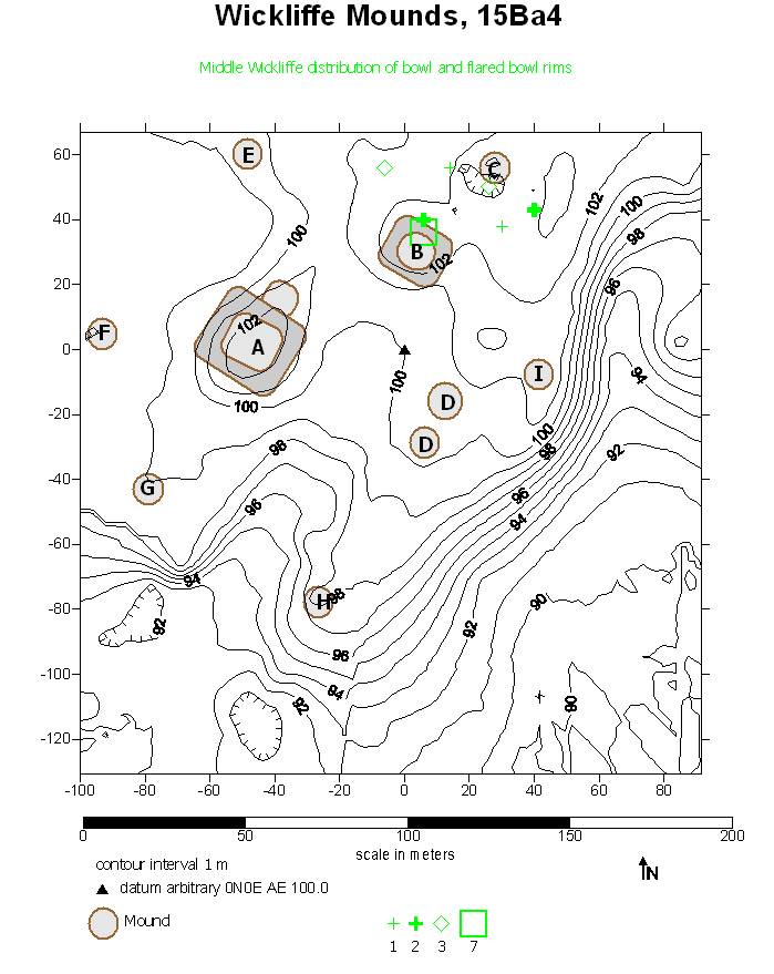
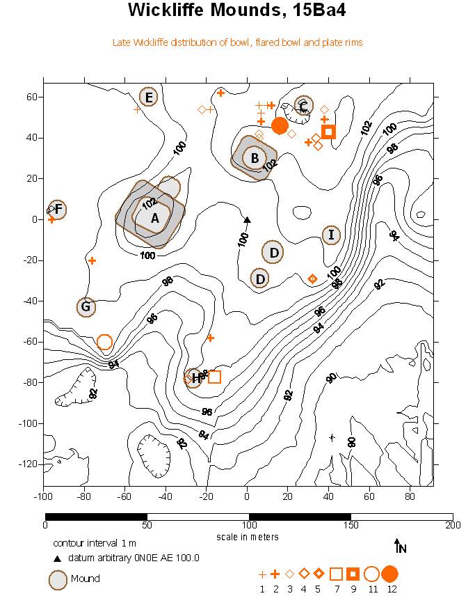
Looking directly at the distribution of serving vessels, particularly bowls, flare-rimmed bowls, and plates (bottles are too few in number to demonstrate significant patterning), provides another perspective on where serving activities concentrated. The EWp has only bowls (Figure 24), and the largest numbers are where the higher s/c ratios were in the same period (Figure 21). Flare-rimmed bowls are Middle Wickliffe introductions, while un-flared bowls persist. Figure 25 shows that these two rim types are strongly concentrated in Mound B and all of them are in the Mounds B-C sector of the site. Both vessel types persist into the LWp but are supplemented by plates. Figure 26 shows that these three serving vessel forms appear in the largest quantities in the Mounds B-C sector, but also are scattered all over the village. Figures 24-26, the distributions of serving vessel rims, corroborate the distributions of higher s/c ratios as previously illustrated (Figures 18-23).
|
Figure 24. Distribution of Early Wickliffe bowl rims. |
Figure 25. Distribution of Middle Wickliffe bowl and flare-rim bowl rims. |
Figure 26. Distribution of Late Wickliffe bowl, flare-rim bowl and plate rims. |
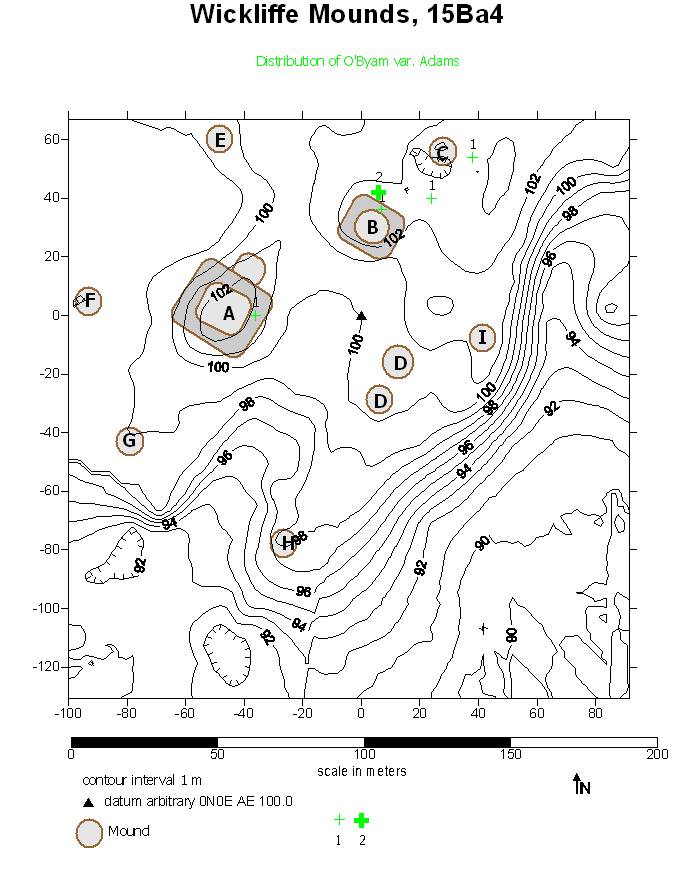
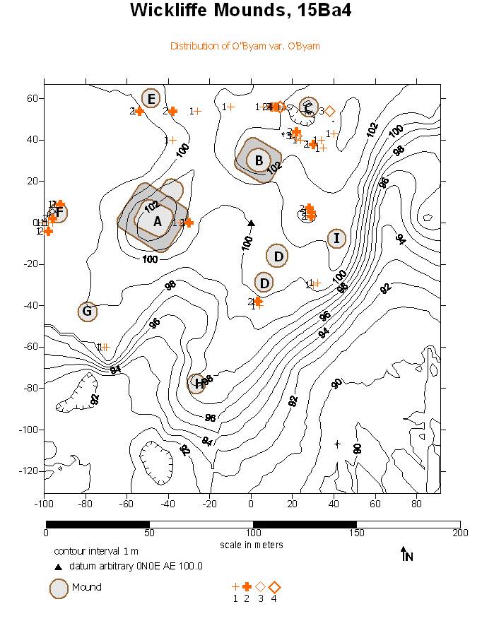
It is interesting to compare the distributions of certain specific decorated ceramic types which may be thought of as “fancy” vessels. O’Byam Incised var. Adams, a decorated fineware flare-rimmed bowl, is an MWp temporal marker. Var. Adams appears in the arguably elite-oriented contexts: the two platform mounds and the Mound B-C vicinity (Figure 27). O’Byam Incised var. O’Byam, the LWp fineware plate which, in terms of form and style, succeeded var. Adams, is by contrast distributed throughout the site (Figure 28). Rather than elite markers, these types may be seen simply as decorated serving vessels.
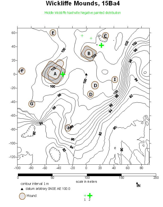
Nashville Negative painted sherds represent another “fancy” ware often associated with serving vessels such as plates and bottles. This type was introduced in the MWp, where its distribution (Figure 29) closely resembles that of O’Byam Incised var. Adams. Figure 30 shows that the LWp distribution of Nashville Negative is more scattered than in the MWp, much as O’Byam var. O’Byam is more widely dispersed than var. Adams. Two aspects of the Nashville Negative distributions are notable. The first is that, like O’Byam Incised, they appear not to be elite items but more in the nature of fancy serving items in community-wide use in the LWp. Second is the concentration in LWp northeast of Mound I. This location is a local topographic high, and is in fact the remnant toe of Mound D, in which the LWp Feature 112 produced a partially reconstructable Nashville Negative head pot (Wesler 1991, 2001:Figures 4.8 and 4.9). Sherds from features are not included in this analysis.
In sum, the area between Mound B, the elite residential mound, and Mound C, the cemetery, became a focus of higher serving-to-cooking vessel ratio in the Middle Wickliffe period. I posit that this area is in effect the “yard” of the chief’s residence, the area most directly controlled by the chief’s household.
|
Figure 27. Distribution of O’Byam var. Adams rim sherds. |
Figure 28. Distribution of O’Byam var. O’Byam rim sherds. |
Figure 29. Distribution of Middle Wickliffe Nashville Negative painted sherds. |
Figure 30. Distribution of Late Wickliffe Nashville Negative painted sherds. |

Discussion
This research began as a purely exploratory exercise in mapping available ceramic data. Bearing in mind previous analyses (Wesler 2001), I focused on (although “played with” might be a more appropriate phrase) distributions of ceramics and ceramic types identified in middens that could be assigned to the three Wickliffe periods, Early, Middle and Late. To the extent that there was a hypothesis, it was that higher serving-to-cooking/utilitarian vessel ratios would highlight Mound B as an elite residence in the MWp. The results suggest two major conclusions: first, that the area between Mounds B and C is unusually characterized by serving vessels especially in the MWp, and second, that the pattern can only be seen in the perspective of the spatial analysis of the entire site and entire assemblage.
I suggest that the area between Mounds B and C was the focus of elite-dominated food serving events, in effect the yard of the chief’s residence. This would have been an area fraught with meaning, between the chief’s residence and the cemetery, which the chief brought into the village. It also would have been blocked visually from the top of Mound A by the bulk of Mound B, which may or may not be significant.
Kreisa and McDowell’s (2001) study of a small set of faunal samples noted better cuts of venison in the Mound B middens, suggesting a choice diet for the elite family. Although not a focus of the Wickliffe study, faunal studies went through a period of preoccupation with “feasting” in the last couple of decades (for a sample, see Adams 2004; Blitz 1993; Bray ed. 2003; Chicoine 2011; Clark and Blake 1994; Dietler 1996; Dietler and Hayden eds. 2001; Gumerman 1997; Hayden 1996; Jennings 2005; Knight 2001; Mills 2007; Pauketat et al. 2002; Potter 2000; VanDerwarker 1999). VanDerwarker (1999) specifies some of the markers of feasting deposits, including special foods and vessels, combinations of foodstuffs, a lower species diversity (that is, a concentration on a few species), density of food remains, high serving-to-cooking vessel ratios, vessel size, and special activity areas. Some of these markers already seem to characterize the proposed chief’s yard at Wickliffe. However, embedded in the concept of feasting deposits is the idea of “single-event dumping episodes” (Pauketat et al. 2002; e.g. Kelly 2001), not the midden accumulation I have identified for the yard.
Because the ceramics analyzed so far represent undifferentiated (within each Wickliffe period) middens, the term “feasting” is not apt; “feasting” should be visible in short-term deposits such as stratigraphic lenses or features. The midden deposits of the yard, consolidating longer-term activities, may represent (1) preferred deposition of elite household refuse, perhaps dumped off Mound B, or (2) an area controlled by the chief and used for ceremonial, political and social events. One reviewer of this paper (R. B. Clay, pers. comm. 2013) wondered whether “an area of the site controlled by an elite for functions directed by the elite … would be rather rigorously ‘maintained,’ that is cleaned,” and thus “look very barren.” This is a worthy question. No area of the site other than the presumed plaza shows such characteristics. If the hosted events happened in the plaza, would the refuse have been preferentially dumped between Mounds B and C? More likely the chief’s yard midden would represent hypothesis (1).
Under hypothesis (2), the events may have included feasts. In Hayden’s (1996) categorization, feasting events may be minimally distinctive (family or small group events of varying formality), promotional/alliance or tribute feasts (especially intra-site diplomatic and hospitality functions), or competitive feasts, but the lack of a concentration of luxury items at Wickliffe argues against competitive feasting. Knight’s (2001) model of communal/renewal ceremonialism may also be applied. Before any of these kinds of food-focused events may be distinguished, it will be necessary first to characterize fully the distinctness of the deposits within the site using ceramic and faunal data in conjunction.
On the other hand, there are large features which call for investigation as potential feasting deposits, particularly Feature 238, an EWp feature under the northern edge of Mound B, and Feature 112, noted above (Wesler 1991, 2001). Therefore, the ceramics and faunal remains from feature contexts also need to be analyzed, along with the faunal remains from middens.
A tactic more useful than feature-focused analysis would incorporate the special-deposit feasting idea with a more subtle view of the variation among deposits across the site. VanDerwarker and Idol (2008) take such an approach to features, suggesting that feature assemblages may indicate differences in seasonal activity, seasonal availability of resources, and special activities such as routine cleaning, ritual cleansing, and probably others. Barrier (2011) takes a similarly broader view looking at jar sizes at Moundville, citing Knight (2010) in writing that “elite extraction of resources, skilled production, and consumption of skilled crafts were diffuse…” across the site.
A third data set with potential for illuminating these issues is the lithics. As with Kreisa and McDowell’s (2001), study Koldehoff and Carr’s (2001) study of Wickliffe lithics was based on a few provenience lots selected for temporal patterning. The size and site-wide distribution of the Wickliffe lithic sample make it an excellent test case for Carr and Bradbury’s (2000) call for integration of debitage and tool analysis, the identification of geological sources, and organization of technology approaches. Jeske (2003) further identifies problem areas for lithic studies, including the relationships of social organization, mobility and settlement to lithic assemblage organization, using such measures as flake to tool ratios, origin and quality of raw material, intensity of tool use and curation, and scavenging of earlier sites for raw materials. Indeed, the relative frequencies of tools in EWp, MWp, and LWp deposits at Wickliffe as well as the occurrence of projectile points collected from pre-Mississippian sites have been remarked upon previously (Wesler 2001).
The initial study of Wickliffe lithics by Koldehoff and Carr (2001) forms a basis for further work on the collection. It combined an organization of technology approach with identification of lithic source-types. Mississippian lithic technology is largely expedient (Teltser 1991), though Wickliffe formal tools include projectile points, drills, bifaces of various forms, and a few microdrills. Wickliffe sources include local Mounds gravels as well as imports identified as being from Dover (Tennessee), Mill Creek and Kaolin (Southern Illinois) and Burlington (Missouri) sources. Such source studies help inform models of trade connections. One problem with source studies is that visually similar cherts may be found in geological formations that cover large areas, raising the question of whether a specimen actually came from the quarry we know about. Parish (2009, 2011) recently documented a hyperspectral signature for chert from the Dover quarries which may be used to test whether a specimen that looks like Dover chert is, in fact, likely to be from that quarry, a technique that will be usefully applied to other cherts.
Both organization of technology and source studies also bear on issues of chiefly control of trade and craft production. Dover chert apparently was traded widely and used for both utilitarian items (especially hoes) and large ceremonial or authoritarian bifaces. Gramly (1992) excavated a house at Dover and suggested that the inhabitants produced huge quantities of product for export, raising the question of whether either the crafters or the quarries might have been controlled by a nearby authority. Mill Creek chert (Cobb 2000; Koldehoff 1986) was also traded widely, but rarely if ever for elite items. It seems to have been suited more for hoes. Still, at issue is whether a local chiefly authority controlled access and production. Cobb (2000), in the most extensive study of the Mill Creek quarries, thinks that there is little evidence for centralized control at Mill Creek.
Whether the source was controlled or not is a separate question from whether moderately distant recipients like a elite of Wickliffe would have exercised some level of authority over imports. As Wilson (2001) writes, “Dominating the circulation of utilitarian tools… would have provided chiefly administrators with more direct and coercive control over the means of production.” Other scholars have considered the control of craft production as an elite strategy (e.g.. Brown et al. 1990; Muller 1997; Welch 1991) as well as the problem of differentiating between elite and utilitarian crafts (Cobb 2000; Koldehoff 1986; Muller 1984, 1986; Pauketat 1997). Wilson’s study of greenstone at Moundville, which like Dover was used for both fine/elite and utilitarian items, will be a good comparison. Expedient recycling of greenstone at Moundville suggests that celts were widely available and not centrally controlled (Wilson 2000). However, as noted earlier, there is some indication that large flakes, perhaps blanks for further reduction, of Mill Creek chert occur at Wickliffe, and large flakes in general seem to centralize near Mound B in the MWp, so the question is open at Wickliffe. Fully analyzed from middens and features, the Wickliffe lithics would be well suited for the same kind of mapping exercise as the ceramics, and in comparison to the ceramics and the faunal remains, would provide a very thorough view of the organization of several types of activities. In particular, these data would allow a test of whether the chief’s yard is distinct across multiple assemblage categories.
I note two aspects of both Barrier’s (2011) and Wilson’s (2001) studies as they compare to those in progress at Wickliffe. First, they rely on tables of frequencies drawn from a few proveniences for their analysis and presentation (as did Wesler [2001] for Wickliffe). The approach in the present study incorporates all midden proveniences and analyzes them spatially and visually, highlighting distinct areas and deposits much more comprehensively.
Second, Wickliffe is a village and society of much smaller scale than Moundville. There is evidence for only a single elite focus, Mound B, at Wickliffe. The opportunities for a top tier of society to have incorporated competing factions (a feature particularly of Barrier’s analysis) are much more limited. The question at Wickliffe, then, will (probably!) have to do more with an elite asserting and maintaining control over a non-elite population than with internal rivalry among elites. In fact, elite rivalry may have operated on more of a regional scale in western Kentucky, but considerably more data from regional sites will be needed for such comparisons (Wesler 2006c).
Conclusion
As Milner (2003) illustrates for Cahokia, most Mississipianists concentrate on architecture, burials and cemeteries, and “nonperishable fancy artifacts” to identify elite contexts in Mississippian sites, and focus on mound deposits. My previous analyses of the Wickliffe Mounds site followed the same pattern. However, this paper highlights an off-mound context and characterizes an elite-controlled locus of activities through multi-dataset characteristics of the ceramic assemblages in spatial perspective.
This analysis supports but expands previous interpretations (Wesler 2001). The EWp Wickliffe village was relatively small in area, and the major ceramic wares show little spatial pattern. There is some evidence for higher s/c ratios in the vicinities of the two platform mounds, particularly at the north side of Mound B. This finding will need further analysis when Feature 328, noted above as a deposit to be investigated for indications of “feasting,” is analyzed fully, but for now, the EWp village suggests relatively little internal diversity.
In the MWp, however, the area between Mound B and C becomes a focus of serving vessels. This pattern is consistent with previous analyses that the MWp was when a chief resided in the village, and suggests that the chief hosted activities (feasts, diplomatic functions, social events) here. Unlike larger Mississippian centers with large mounds, such as Monks Mound at Cahokia (Fowler 1997:87-102) or Mounds A and C at Etowah (King 2006; King et al. 2011), there was too little space atop Wickliffe’s Mound B to allow for gatherings, and it seems that the Wickliffe chief’s yard was therefore beside the mound. As previously suggested, however, the spatial analysis indicates that the elite family led the way in a new type of foodway emphasizing serving vessels.
In the LWp, the areas of higher s/c ratios as well as serving vessels and “fancy” wares became much more widespread. Centralized control relaxed, whether by the absence of a chief in residence or a lessening of authority as expressed in hosted events. This analysis supports previous interpretations that the removal of the burial program from the village, the final capping of the platform mounds, and other assemblage indicators (Wesler 2001) reflected less centralized organization. The new foodway pattern that encouraged serving vessels spread throughout the village. Whether or how this might be related to the decline in fish in the diet (Kreisa and McDowell 2001; Wesler 2001:109-113) is unclear.
The data from Wickliffe Mounds, specifically those from 15 seasons of excavations that used consistent recording methods, have been systematically digitized into a relational database suitable for spatial analysis. This project demonstrates the advantage of fully-digitized and fully analyzed archaeological assemblages in the investigation of intra-site patterning in a small but complex village site. Modern spatial analysis and visualization software both allow and require the use of larger and more complex data sets than can be presented effectively through traditional means, whether by hand-drawn figures or numerical tables.
The relatively small size of the Wickliffe site, as compared to, for example, Cahokia or Moundville, means that the database is an effective sample of the contexts of the village. The internal three-period chronology allows a dynamic view of the settlement through time and across the village. Elite vs. non-elite relations here are a microcosm of the complex sociopolitical organization of the Mississippian world.
Because the identification of the chief’s yard comes into focus through the spatial study of all analyzed midden deposits on the site, only through the equally complete analysis of the other major categories of assemblages—lithic and faunal—can the chief’s yard be understood fully. The degree to which the yard’s assemblage is distinguishable from the rest of the village in each period will indicate the chief’s role as leader and status manager, and how that role developed and changed through the period of occupation of the site.
Modern digital recording and mapping techniques not only allow but demand larger quantities of fully-analyzed data to be used effectively. We can no longer accept that a few samples from selected contexts within a complex site such as a Mississippian village can characterize the site or its society. This project serves as a demonstration that full analysis of large datasets is feasible and informative.
Acknowledgment
A brief version of this paper was presented to the annual Mississippian Conference, Cahokia Mounds State Historic Site, Collinsville, Illinois, July 28, 2012. I thank Berle Clay and Lara Homsey for comments on the draft of the current version.
References cited
Adams, Ron L.
2004 An Ethnoarchaeological Study of Feasting in Sulawesi, Indonesia. Journal of Anthropological Archaeology 23:56-78.
Barrier, Casey R.
2011 Storage and relative surplus at the Mississippian site of Moundville. Journal of Anthropological Archaeology 30(2):206-219.
Blitz, John
1993 Big Pots for Big Shots: Feasting and Storage in a Mississippian Community. American Antiquity 58:80–96.
Bray, Tamara, ed.
2003 The Archaeology and Politics of Food and Feasting in Early States and Empires. Kluwer Academic/Plenum Publishers, New York.
Brown, James A., Richard A. Kerber, and Howard D. Winters
1990 Trade and the Evolution of Exchange relations at the Beginning of the Mississippian Period. In The Mississippian Emergence, edited by Bruce D. Smith, pp. 251-280. Smithsonian Institution Press, Washington DC.
Brown, Kristin
2001 Spatial Perspectives on Wickliffe Assemblages. In Excavations at Wickliffe Mounds, by Kit W. Wesler, Chapter 8 (CD-ROM). University of Alabama Press, Tuscaloosa.
Carr, Philip J., and Andrew P. Bradbury
2000 Contemporary Lithic Analysis and Southeastern Archaeology. Southeastern Archaeology 19(2):120-134.
Chicoine, David
2011 Feasting Landscapes and Political Economy at the Early Horizon Center of Huambacho, Nepeña Valley, Peru. Journal of Anthropological Archaeology 30(3):432-453.
Clark, John, and Michael Blake
1994 The Power of Prestige: Competitive Generosity and the Emergence of Rank Societies in Lowland Mesoamerica. In Factional Competition and Political Development in the New World, edited by Elizabeth M. Brumfiel and Jonathon W. Fox, pp. 17–30. : Cambridge University Press, New York.
Cobb, Charles R.
2000 From Quarry to Cornfield: The Political Economy of Mississippian Hoe Production. University of Alabama press, Tuscaloosa.
Dietler, Michael
1996 Feast and Commensal Politics in the Political Economy: Food, Power, and Status in Prehistoric Europe. In Food and the Status Quest, edited by Polly Wiessner and Wulf Schiefenhovel, pp. 87-125. Berghahn Books, Oxford.
Dietler, Michael, and Brian Hayden, eds.
2001 Feasts: Archaeological and Ethnographic Perspectives on Food, Politics, and Power. Smithsonian Institution Press, Washington, DC.
Fowler, Melvin J.
1997 The Cahokia Atlas, Revised: A Historical Atlas of Cahokia Archaeology, No. 2. Illinois Transportation Archaeological Research Program, Urbana.
Golden Software
2006 Surfer(R) Version 8.06. Golden Software, Inc., Golden, Colorado.
Gramly, R. Michael
1992 Prehistoric Lithic Industry at Dover, Tennessee. Persimmon Press, Buffalo.
Gumerman, George J.
1997 Food and Complex Societies. Journal of Archaeological Method and Theory 4:105–139.
Hally, David J.
1996 Platform-mound construction and the instability of Mississippian chiefdoms. In J. F. Scarry, ed., Political Structure and Change in the Prehistoric Southeastern United States, pp. 92-127. University Press of Florida, Gainesville.
Hayden, Brian
1996 Feasting in Prehistoric and Traditional Societies. In Food and the Status Quest, edited by Polly Wiessner and Wulf Schiefenhovel,. pp. 127–148. Berghahn Books, Oxford.
Jennings, Justin
2005 La Chichera y El Patrón: Chicha and the Energetics of Feasting in the Prehistoric Andes. Archaeological Papers of the American Anthropological Association 14:241–259.
Jeske, Robert J.
2003 Lithic Raw Material Procurement and Use within Mississippian Social Networks. In Theory, Method, and Practice in Modern Archaeology, edited by Robert J. Jeske and Douglas K. Charles, pp. 223-237. Praeger Publishers, Santa Barbara.
Kelly, Lucretia S.
2001 A Case of Ritual feasting at the Cahokia Site. In Feasts: Archaeological and Ethnographic perspectives on Food, Politics and Power, edited by Michael Dietler and Brian Hayden, pp. 334-367. Smithsonian Institution Press, Washington.
King, Adam
2006 Remote Sensing Reveals a Sacred Precinct on Etowah’s Mound A. Legacy 10(2):6-9.
King A, Chester P. Walker, Robert V. Sharp, F. Kent Reilly, and Duncan P. McKinnon
2011 Remote sensing from Etowah's Mound A: Architecture and the re-creation of Mississippian tradition. American Antiquity 76(2):335-371.
Knight, Vernon J.
2001 Feasting and the Emergence of Platform Mound Ceremonialism in Eastern North America. In Feasts: Archaeological and Ethnographic perspectives on Food, Politics and Power, edited by Michael Dietler and Brian Hayden, pp. 311-333. Smithsonian Institution Press, Washington.
2010 Mound Excavations at Moundville: Architecture, Elites, and Social Order. University of Alabama Press, Tuscaloosa.
Koldehoff, Brad
1986 Lithic Analysis. In The Bonnie creek Site: A Late Mississippian Homestead in the Upper Galum Creek Valley, Perry County, Illinois, by M. J. Wagner, pp. 15-198. American Resource Group Preservation Series 3. Carbondale, IL.
Koldehoff, Brad, and Phillip J. Carr
2001 Chipped Stone Technology: Patterns of Procurement, Production, and Consumption. In Excavations at Wickliffe Mounds, by Kit W. Wesler, Chapter 10 (CD-ROM). University of Alabama Press, Tuscaloosa.
Kreisa, Paul P., and Jacqueline M. McDowell
2001 An Analysis of Faunal Remains from Selected WMRC Excavations. In Excavations at Wickliffe Mounds, by Kit W. Wesler, Chapter 15 (CD-ROM). University of Alabama Press, Tuscaloosa.
Lewis, R. Barry, ed.
1986 Mississippian Towns of the Western Kentucky Border: the Adams, Wickliffe, and Sassafras Ridge sites. Kentucky Heritage Council.
Loughridge, R. H.
1888 Report on the Geological and Economic Features of the Jackson Purchase Region. Kentucky Geological Survey, Frankfort.
Matternes, Hugh Bryson
2000 Social and biological structures in the Mound C Cemetery, Wickliffe Mound Group (15BA4). Ph.D. dissertation, Department of Anthropology, University of Tennessee, Knoxville.
Mills, Barbara J.
2007 Performing the Feast: Visual Display and Suprahousehold Commensalism in the Puebloan Southwest. American Antiquity 72(2):210-239.
Milner, George R.
2003 Archaeological Indicators of Rank in the Cahokia Chiefdom. In Theory, Method, and Practice in Modern Archaeology, edited by Robert J. Jeske and Douglas K. Charles, pp. 133-148. Praeger Publishers, Santa Barbara.
Morse, Dan F., and Phyllis A. Morse, eds.
1998 The Lower Mississippi Valley Expeditions of Clarence Bloomfield Moore. University of Alabama Press, Tuscaloosa.
Muller, Jon
1984 Mississippian Specialization and Salt. American Antiquity 49:489-507.
1986 Pans and a grain of Salt: Mississippian Specialization Revisited. American Antiquity 51(2):405-409.
1997 Mississippian Political Economy. Plenum Press, New York.
Parish, Ryan
2009 A Chert Sourcing Study Using Visible\Near-Infrared Reflectance Spectroscopy at the Dover Quarry Sites, Tennessee. M.Sc. thesis, Department of Geosciences, Murray State University, Murray KY.
2011 The application of visible/near-infrared reflectance (VNIR) spectroscopy to chert: A case study from the Dover Quarry sites, Tennessee. Geoarchaeology 26(3):420-439.
Pauketat, Timothy R.
1997 Specialization, Political Symbols, and the Crafty Elite of Cahokia. Southeastern Archaeology 16(1):1-15.
Pauketat, Timothy R., Lucretia S. Kelly, Gayle J. Fritz, Neal H. Lopinot, Scott Elias, and Eve Hargrave
2002 The Residues of Feasting and Public Ritual at Early Cahokia. American Antiquity 67:257-279.
Potter, James M.
2000 Pots, Parties, and Politics: Communal Feasting in the American Southwest. American Antiquity 65:471-492.
Teltser, Patrice A.
1991 Generalized Core Technology and Tool Use: A Mississippian Example. Journal of Field Archaeology 18(3):363-375.
VanDerwarker, Amber M.
1999 Feasting and Status at the Toqua Site. Southeastern Archaeology 18(1):24-34.
VanDerwarker, Amber M., and Bruce Idol
2008 Rotten Food and Ritual Behavior: Late Woodland Plant Foodways and Special Purpose Features at Buzzard Rock II, Virginia (44RN2/70). Southeastern Archaeology 27(1):61-77.
Welch, Paul D.
1991 Moundville’s Economy. University of Alabama Press, Tuscaloosa.
Wesler, Kit W.
1991 Ceramics, chronology, and horizon markers at Wickliffe Mounds, 15Ba4. American Antiquity 56(2):278-290.
1996 An elite burial mound at Wickliffe? In Robert C. Mainfort, Jr., and Richard Walling, eds., Mounds, Embankments, and Ceremonialism: Proceedings of the 11th Annual Mid-South Archaeological Conference, 1990. Arkansas Archaeological Survey, Fayetteville.
2001 Excavations at Wickliffe Mounds. The University of Alabama Press, Tuscaloosa.
2006a Modeling Mississippian as non-State: a Narrowness of Vision? Presented to the Society for American Archaeology, San Juan, Puerto Rico, April 30.
2006b Wickliffe’s Mound D Revisited (Yet Again). Presented to the Symposium “New Research at Late Prehistoric Mound Sites in the Midsouth,” at the Southeastern Archaeological Conference, Little Rock, Arkansas, 10 November 2006.
2006c Platforms as Chiefs: Comparing Mound Sequences in Western Kentucky. in Leadership and Polity in Mississippian Society, edited by Brian M. Butler and Paul D. Welch, pp. 142-155. Occasional Paper No. 33. Center for Archaeological Investigations, Southern Illinois University, Carbondale, Illinois.
2009 Digitization and the Murray State University Archaeology Program. Presented to the Kentucky Heritage Council Archaeology Conference, Murray KY, March 8, 2009.
Wilson, Gregory D.
2001 Crafting Control and the Control of Crafts: Rethinking the Moundville Greenstone Industry. Southeastern Archaeology 20(2):118-128.
Editor’s note: This paper was accepted after Tier II review (see Author’s Guidelines).