Rivers and Rifles: The Role of Fort Heiman in
the Western Theater of the Civil War
Timothy
A. Parsons
Abstract
Between 1861 and 1864, a triumvirate of Forts – Henry, Donelson, and
Heiman – played a pivotal role in the western theater of the Civil War. Of the three, Fort Heiman changed hands most
often, and despite its relative obscurity was a keystone for the Union and
Confederacy in regulating military transport and commerce on the Tennessee
River. In late 2010, archaeologists from
the National Park Service Southeast Archeological Center investigated Fort
Heiman to distinguish between Confederate and Union landscape features, and to
shed light on the role of African American Freedmen living at the fort during
its Northern occupation. Ultimately,
the landscape surrounding Fort Heiman was found to be highly disturbed by relic
collectors. And, although impossible to
distinguish between Union and Confederate forces based on the artifact
assemblage, the identification of several earthworks and landscape features
sheds new light on the occupation of the area during the Civil War.
Introduction
Early in the Civil War, control of navigable
waterways was of paramount strategic concern.
The Cumberland and Tennessee Rivers, as part of the Mississippi River
drainage, were important transportation and trade routes flowing directly into
the heart of the Confederacy. This paper
recounts the importance of maritime superiority in the western theater of the
Civil War prior to 1864, and focuses on the roles of three Confederate forts in
the defense and control of the rivers – Forts Heiman, Henry, and Donelson. The subject is approached through the lens of
Phase I and Phase II archaeological survey at the Fort Heiman unit of Fort
Donelson National Battlefield, as part of the National Park Service’s National
Historic Preservation Act (NHPA) Section 110 site inventory and evaluation
obligations.
Controlling
the Cumberland and Tennessee Rivers, 1860-1863
Kentucky was strategically important to both the Union North and
Confederate South. Demographically, the
state ranked ninth in population by 1860 and produced important agricultural
commodities such as tobacco, corn, wheat, hemp, and flax; its neutral status at
the outset of the war thus made it desirable territory for both the North and
the South. Even more importantly, the
transportation role of the Tennessee River was recognized and coveted by both
parties. The Confederate rush to fortify
this vital transportation and potential invasion route is demonstrative of the
region’s role as a linchpin during the early days of the Civil War (Figure 1). Indeed, western Kentucky was of such
strategic value to both sides that President Abraham Lincoln wrote, “I think to
lose Kentucky is nearly the same as to lose the whole game…We would as well
consent to separation at once, including the surrender of the capital”
(Harrison and Klotter 1975:3).
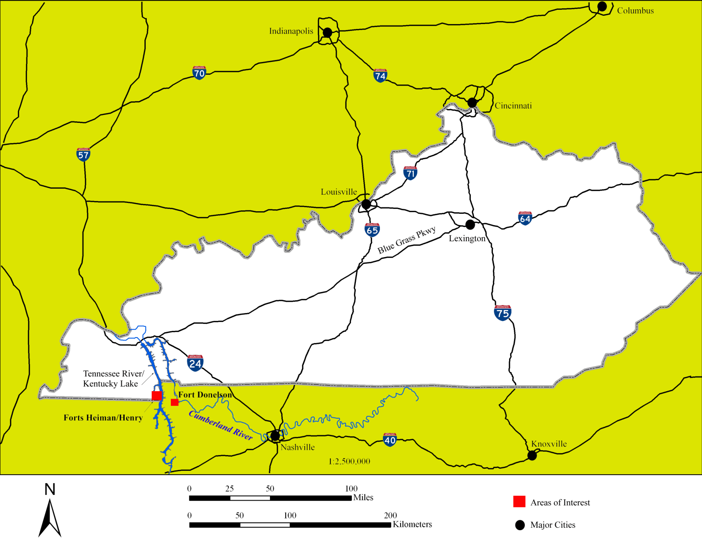
Figure
1: Locational map of Fort Heiman, Fort Henry, Fort Donelson, and relevant
rivers and lakes.
Though this series of battles on the
Cumberland and Tennessee Rivers is often glossed over in summaries of the Civil
War, the fights for control of these important waterways greatly affected
momentum and strategy early on in the conflict.
Fort Heiman, especially, is often left out of narratives of the Battle
of Fort Henry. Despite the relatively
small role played by Fort Heiman in defense of Fort Henry and the Tennessee
River, it nonetheless saw several subsequent occupations by Union and
Confederate forces during the war, and shaped the conflict in the western
theater for years to come.
Defending
the Rivers
The Civil War in the Lower Tennessee-Cumberland region of western
Kentucky and Tennessee was defined by the positions played by three forts along
the Tennessee and Cumberland Rivers: Forts Henry, Heiman, and Donelson (Figure 2). Indeed, the extreme western portion of the
state was extremely important due to the Mississippi, Cumberland, and Tennessee
Rivers— all the modern equivalent of highways to the heart of the Confederacy
if they came under Federal control.
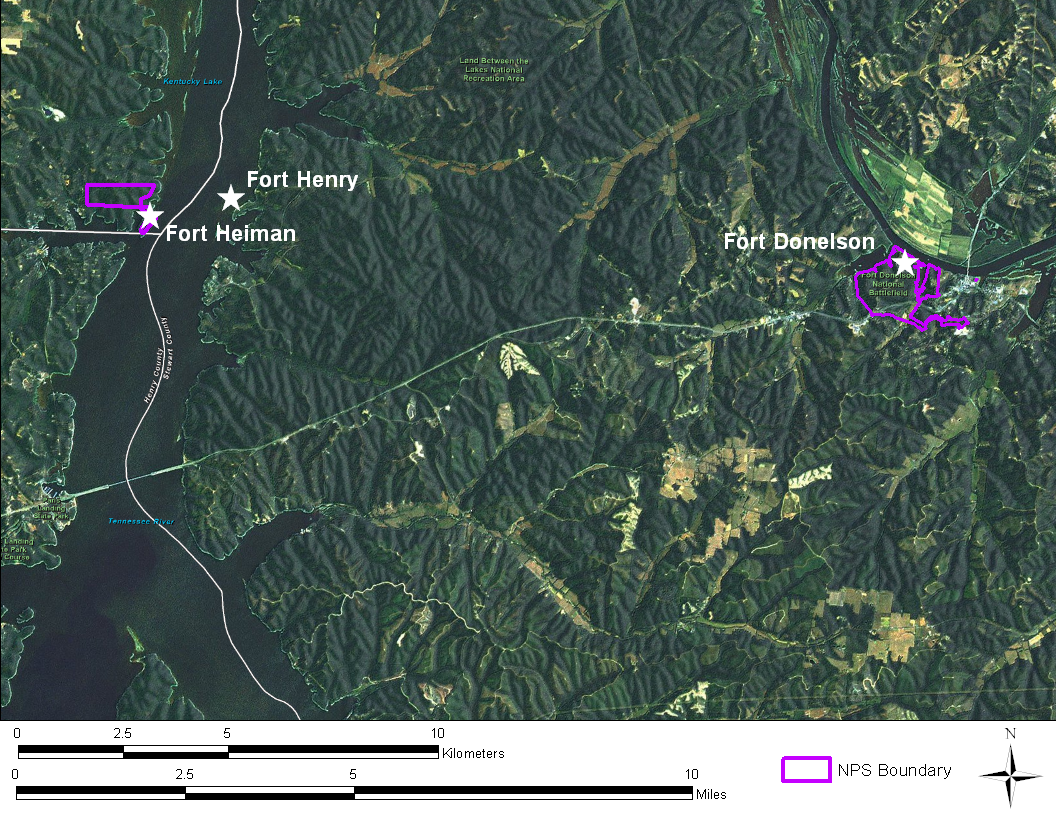
Figure 2:
The locations of Forts Heiman, Henry, and Donelson along the Tennessee and
Cumberland Rivers. Note that Fort Henry
is submerged beneath Kentucky Lake in this modern satellite imagery (imagery
from ESRI 2011).
In order to prevent a Union invasion along these key transportation
arteries, the Confederacy constructed Fort Donelson on the Cumberland River at
Dover, Tennessee, and Fort Henry on the eastern bank of the Tennessee by June
of 1861 (Cooling 1987:48). Despite there
being a more appropriate battery location on the elevated bluffs overlooking
the western bank of the river, due to Kentucky’s neutral status, Fort Henry was
placed upon low-lying ground in Tennessee. Its proximity to Kentucky and its
command over a long, straight stretch of the Tennessee River also contributed
to its strategic placement. Two months
later, in September 1861, Confederate forces under General S.B. Buckner seized
and occupied Bowling Green, Kentucky in order to impede Union railroad
operations in the region (Eisterhold 1974:43).
This opened the door for further Confederate military inroads and the
building of fortifications in the state.
The
Construction and First Confederate Occupation of Fort Heiman
Upon Brig. Gen. Lloyd Tilghman’s arrival as commander of
Forts Henry and Donelson in late 1861, he immediately recognized Fort Henry’s
susceptibility to floodwaters (Lampley 2008).
Indeed, Fort Henry’s position was described as “wretched” by both Major
J. F. Gilmer, a Confederate engineer who arrived at the fort after its
construction and would select the location for Fort Heiman (United States War
Department 1882:131), and by Tilghman himself, as shown in his report of the
battle and Confederate surrender.
Tilghman understood what Confederate engineers apparently had not—nature
was more certain to destroy Fort Henry than any Union gunboat, and wrote that
“the history of military engineering records no parallel to this case”
(Tilghman 1882:139). Thus understanding
the fort’s precarious situation, Tilghman sent Colonel Adolphus Heiman,
commander of the Tenth Tennessee Regiment, and his chief engineer Major Gilmer,
to the high bluffs on the Kentucky bank of the river to determine if the land
could accommodate heavy artillery and suitably protect Fort Henry. Gilmer selected a location approximately
one-and-a-half miles from the existing fort, on the opposite side of the
Tennessee River (Figure 3).
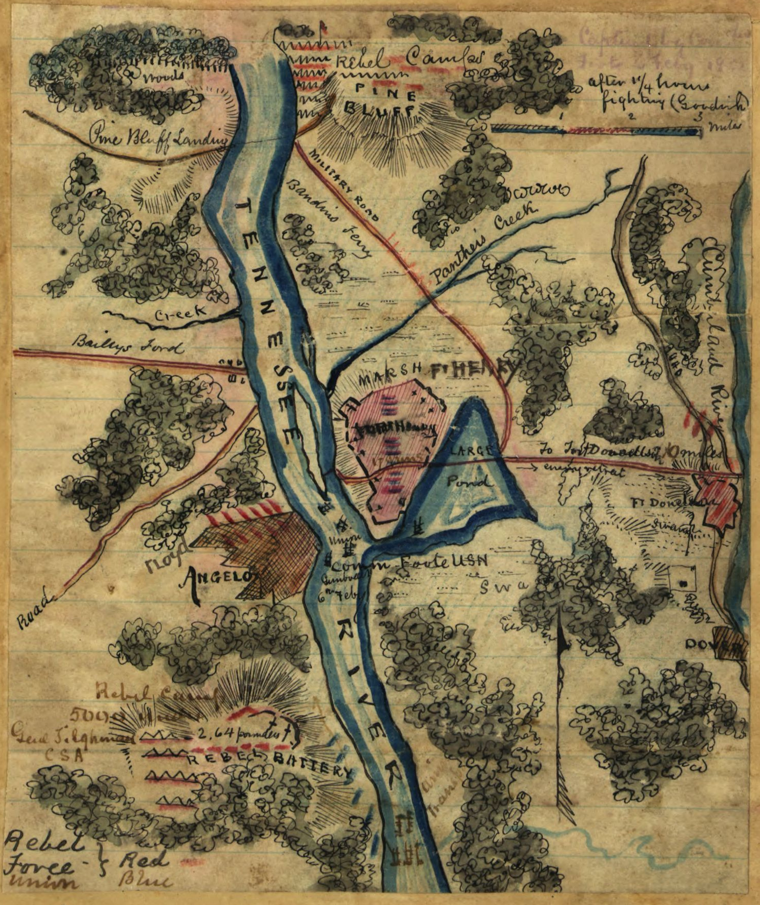
Figure 3:
The only known contemporary map showing the location of Fort Heiman, along with
Fort Henry and Union and Confederate military positions. The map is contained in the Robert Knox
Sneden Scrapbook (Mss5:7 Sn237:1 p. 437) curated at the Library of
Congress. Courtesy of the Virginia
Historical Society.
Construction began in December 1861 with the
arrival of the Twenty-seventh Alabama and Fifteenth Arkansas infantry regiments
who, along with some 500 slaves, were tasked with building the works. Its suitable defensive position—protected by
150 foot bluffs in front and impassible roads and rough terrain in the
rear—stood in marked contrast to the poor placement of Fort Henry (Eisterhold
1974:45).
Tilghman had hoped to place large Parrott
rifles overlooking the Tennessee River by the second week of February
(Eisterhold 1974:45; Lampley 2008). On
the morning of February 3, General Tilghman made an inspection of the incomplete
works at Fort Heiman. Satisfied with the
progress, the General subsequently left
for Fort Donelson to make a similar inspection (Tilghman 1882:137), with work
to continue on the bluffs of the Tennessee River. Unbeknownst to Tilghman, U. S. Grant’s army
of 17,000 Federal troops on gunboats and transports, commanded by Commodore
Andrew Hull Foote, had been moving toward the forts from the north since
February 1 (Eisterhold 1974:43; Force 1881).
Though not yet formally named, this army eventually became known as Grant’s
Army of the Tennessee.
The Battle of Fort Henry
By February 4, Grant’s army had
arrived three miles downstream from Forts Henry and Heiman at Bailey’s
Ferry. This prompted Tilghman to order a
retreat from the unfinished and unequipped Fort Heiman to reinforce Fort Henry
across the river. By this time, Fort
Henry was partially inundated by the Tennessee River following heavy
rains. Tilghman, in recognition of the
difficult situation, ordered the majority of the solders to assist in the
defense of Fort Donelson. He later
rationalized this decision in his after-action report, saying “I deemed it
proper to trust to the fact that the extremely bad roads leading to that point
would prevent the movement of heavy guns by the enemy, by which I might be
annoyed [at Fort Henry]” (Tilghman 1882:138).
Furthermore, Tilghman reasoned that a centralization of troops at Fort
Donelson might allow it to be held, while Fort Henry was a likely loss
regardless of troop number due to its precarious placement and flood waters
that continued to rise. Ironically, it
fell to Colonel Adolphus Heiman to lead the troops away from the fort that bore
his name, leaving only one garrison of between 54 and 90 soldiers to man Fort
Henry’s few guns (Heiman 1882:152).
Following the Confederate
evacuations from Forts Heiman and Henry, the dismal situation failed to improve
for Tilghman and the soldiers under his command. During the night of February 5, Union General
C. F. Smith crossed the Tennessee River from Bailey’s Ferry to occupy the
abandoned Fort Heiman, and General McClernand’s ground troops (under Colonel
Oglesby) began their approach to Fort Henry from the northeast. This left the skeleton crew of Confederate
forces at Fort Henry with few options.
On the morning of February 6, 1862, at 11:45 a.m., Commodore Foote’s
seven gunboats engaged Fort Henry from the north. The river’s high winter floodwaters had
reached the banks of Fort Henry’s earthworks, allowing the approaching Union
gunboats to direct fire on nearly level flight at the fort’s parapets and
guns. By 1:00 p.m., only four of
Tilghman’s guns remained operational, with the General himself operating a
32-pound rifle to relieve the exhausted soldiers. Even worse, only nine of 17 guns remained
above water and could serve as defense (Gott 2003:88-89). Several of the guns experienced mechanical
problems during the battle, with the 10 inch Columbiad vent accidentally spiked
and making it unusable, and one of the 32 pound guns loaded with improper
ammunition exploding and killing two of its operators (Heiman 1882:151). The undermanned and ill-protected Confederate
forces managed to disable at least one boat, the Essex, killing 32 Union
sailors, but ultimately fatigue and equipment failures led Tilghman to
surrender at approximately 2 o’clock on the afternoon of February 6. Though accounts conflict, Confederate
casualties are estimated as high as 15 killed and 20 wounded—ironically being
less than half of the 32 Union soldiers lost aboard the Essex by the victorious
Army of the Tennessee (Gott 2003).
Tilghman himself reported two soldiers killed in his after-action report
(1883:142).
The Battle of Fort
Donelson
The fall of Forts Heiman and Henry opened the door for General Grant’s
troops to march the 12 miles overland to Fort Donelson beginning on February
12, 1862 (McPherson 1883:161). In his
confidence, and perhaps haste, after his victory at Fort Henry, Grant ordered
his troops under General McClernand to quickly advance on Fort Donelson’s
position, bringing with them only what would fit in their rucksacks and two
days worth of provisions (Gott 2003:132).
Though bothered by the Confederate cavalry screen led by Nathan Bedford
Forrest, Grant and a significant portion of his force arrived on the 12th,
as did the USS Carondelet, whose crew probed Fort Donelson’s defenses before
the impending naval battle (Cooling 1987; Gott 2003:144). On February 13, small skirmishes and probing
attacks commenced against the Confederate forces, despite General Grant’s
orders to avoid engagement. C. F. Smith
sent two brigades to test the strength of the opposing defenses, and McClernand
also advanced against the fort. These
advances made no gains, though the Forty-eighth Illinois under Colonel W. H. L.
Wallace managed to silence a battery that had been firing upon Union positions
(Cooling 1987; Gott 2003:157-164).
By February 14, Confederate commanders had determined that a continuing
standoff at Fort Donelson was untenable and commenced with a plan to push
through the Union forces to mount a breakout attempt. General Gideon Pillow, with soldiers ready
behind the lines, postponed the attempt due to the death of an aid at the hands
of a sniper, under the assumption that their movements had been detected and
the maneuvers compromised. This delay
proved costly. At midday, Union forces
were reinforced by the arrival of more ground troops from Fort Henry, as well
as Commodore Foote’s flotilla of six gunboats on the Cumberland River and
10,000 reinforcements on transport ships (McPherson 1882:163). The additional troops allowed for the
reinforcement of McClernand’s right flank, thus making any breakout attempts by
Confederate forces unlikely to succeed.
Foote’s armada would have more of a challenge at Fort Donelson than they
experienced at Fort Henry days earlier.
Almost immediately upon their arrival, Foote proceeded to fire upon the
fort and move within 400 yards of the lower batteries, following a similar
strategy to the one he had employed at Fort Henry (Foote 1882:166). Unlike Fort Henry, however, Fort Donelson’s
artillery imparted significant damage to the fleet, landing more than 150 shots
and killing a number of Union soldiers.
Ultimately, though, the Union retained control of the Cumberland River
despite the damages, and maintained the strategic advantage on land.
The superior Federal strategic position prompted Confederate commanders
to once again consider a breakout attempt, and this time they followed through
with their escape plan. On the morning
of February 15, General Pillow launched an assault against McClernand’s
division on the weaker right flank of the Union line, bolstered by Forrest’s
cavalry and Buckner’s forces from the Confederate right flank, now left
weakened. The attack proceeded as
planned, opening up an escape route, and pushing back McClernand’s force
between one and two miles. However, a
miscalculation by Pillow shortly after midday led to the nearly victorious
Confederate soldiers returning behind the outer works of Fort Donelson, pushed
on by L. Wallace’s reinforcement of McClernand’s forces on the Union right
flank (McPherson 1882:163). The weakness
in the Confederate right flank remained, which Grant quickly exploited by
sending C. F. Smith’s two brigades to take the outer works of the fort
(McClernand 1882:171). The Federal
forces quickly captured the fort’s outer entrenchments, and by nightfall
Confederate forces had lost all ground gained during the day.
On the morning of February 16, Union forces continued to receive
reinforcements. Though initially
bolstered by their successes the previous day, Confederate Generals Floyd,
Pillow, and Buckner quickly realized that, once again, their position was
perilous. Fearing Federal imprisonment
upon defeat or surrender, Floyd and Pillow abandoned their commands (while
Forrest and his cavalry escaped via the path opened by Pillow’s forces the
previous day), leaving Bucker to accept the unconditional surrender offered by
General Grant. If the battle at Fort
Heiman and Fort Henry took a relatively small toll in terms of lives, the
Battle of Fort Donelson was just the opposite.
Between February 11 and 16, Union casualties numbered over 2,600 with
507 killed, and Confederate casualties were nearly 14,000 including prisoners, with
327 left dead (Gott 2003:284-285, 288).
The Consequences of the
Battles
The fall of Fort Henry on February 6 alone
would likely have been enough to allow Union forces to disrupt shipping and
take cities along the Tennessee River, as far as Muscle Shoals, Alabama. Indeed, this took place; however, the
subsequent Confederate defeat at Fort Donelson ensured that the two major water
transportation routes in the Confederate west—the Tennessee and Cumberland
Rivers—became highways for Union troop movements into the south, and served as
supply lines for their support.
Furthermore, Grant’s victories at Henry and Donelson, and the eventual
fall of Nashville to Union forces, threatened the now flanked Confederate
forces in Columbus and Bowling Green, Kentucky, and essentially cut off the
Confederacy from much of the western theater of the Civil War.
Subsequent Military
Occupations of Fort Heiman
After the fall of Fort Donelson, Grant
decided that keeping the Fort Heiman position under Federal control was in the
best interest of the Union, given Fort Henry’s poor placement and the strategic
importance placed on control of the Tennessee River. The task of occupying Fort Heiman fell to
Colonel W. W. Lowe and the Iowa Fifth Cavalry regiment, also known as the
Curtis Horse (Morton and Watkins 1918:411).
Although no battles or skirmishes were fought at Fort Heiman during
their occupation of the post, the Curtis Horse’s time in Kentucky and Tennessee
was not uneventful. Union solders at
Heiman were often bothered by Confederate sympathizing bushwhackers and
partisans, not to mention regular Confederate cavalry, while on patrol. And, several times Union forces engaged
assembled Confederate troops in Paris, Tennessee, usually suffering numerous
casualties. During one particularly
deadly exchange that occurred on March 11, 1862, the Fifth suffered nine
deaths, among them Sergeant Major Martin Stowell, Sergeant David H. Geary,
Private Patrick M. McGuire, Private John W. Warren, Private C. C. Nichelson,
and a Private Dickison (Potter 1993; Baker 1863:565-608; Hays 1865:983).
Military records compiled for the Iowa Fifth Cavalry during the war (Baker
1863:565-608) also identify William Birt, William Snyder, Walter Tuttle, Ernst
Hukride, John A. Duncan, Winston Garrison, Frank Courtney, James M. Hughes,
Lewis Lown, Anton Mayer, Peter Olson, Edward O’Brien, George Stevens, and Franz
Werth as being among the men who died while at Fort Heiman.
Though adequately staffed to hold the fort itself, the Curtis Horse was
never able to maintain control of the region surrounding Fort Heiman. Ultimately, the Iowa Fifth Cavalry remained
at Fort Heiman for one year and four months, leaving on June 25, 1863
(Eisterhold 1974:51; Morton and Watkins 1918:411). Before they left, they did their best to
render the fort unusable, destroying some of the fort’s earthworks and
parapets.
After remaining unoccupied for over a year, Fort Heiman was reoccupied
in autumn of 1864 by Confederate General Nathan Bedford Forrest, his 3,500
soldiers, and a battery of artillery under Captain John Morton. Forrest had been charged with interrupting
Federal riverine transport vessels moving supplies to Sherman’s army in
Georgia. Forrest and Morton placed two
twenty-pound Parrott guns and several light field artillery on the bluffs near
Fort Heiman, for the same reason that Tilghman’s engineers had picked the
location to bolster Fort Henry more than two years before—it presented its
occupants with a commanding position over the Tennessee River, and favorable
geographic location. His strategy was
rewarded with the capture or destruction of five Union supply vessels. Building upon his success, he created the
Confederate Tennessee River Navy by outfitting two vessels with the 20-pound
Parrots, and then used them as a diversion to draw the Union gunboat fleet away
from Johnsonville, Tennessee. While the
gunboats gave chase to his small flotilla, Forrest and his cavalry raided the
town, destroying a Union supply base.
Though his boats were eventually lost, the campaign for the river was
successful overall in that it led to the capture or destruction of four
gunboats, 14 transports, 20 barges, and 26 pieces of artillery, in addition to
the destruction of the Johnsonville supply base (Eisterhold 1974:53).
The
African American Story at Fort Heiman
The Union campaign for Forts Henry, Heiman,
and Donelson provided new opportunities for African Americans in western
Kentucky and northwestern Tennessee to shed the bonds of slavery and live and
work, for the first time, as paid laborers.
This was a critical turning point in African American history, as many
former slaves established churches, built homes and schools, and lived
relatively independently and freely for the first time. They were also important to Union success in
the western theater of the Civil War, not only as logistical support for troops
at the forts, but also as soldiers themselves.
Many of the formerly enslaved men who were recruited after Grant’s
Tennessee River campaign would defend Nashville from Confederate attack in
1964, and also served to guard railroads and supply lines in middle Tennessee
and western Kentucky (Hawkins 2002).
The campaign for the forts along the
Tennessee and Cumberland Rivers, and the presence of the Union Army, was a
turning point for slaves in the region (Hawkins 2002:239; Howard 1982). The African American experience at Fort
Heiman began with its construction, when 500 slaves were assigned, along with
Confederate soldiers, to construct the fort’s earthworks in late 1861. Following Grant’s capture and occupation of
Forts Heiman, Henry, and Donelson in February of 1862, thousands of enslaved
African Americans abandoned their masters in Kentucky and Tennessee and sought
freedom at Union camps surrounding the forts (Hawkins 2002: 223). The migration of slaves to the Union camps
was exacerbated by Grant’s declaration that slaves would be “employed in the
Quarter Master’s Department for the Benefit of the Government” rather than
returned to their masters, essentially offering wages to men and women who
could make it to the camps (Hawkins 2002:225).
In fact, Union victories at Forts Henry and Donelson bought “de facto
army emancipation” to slaves in parts of Kentucky and Tennessee (Cooling:1987). Escaped slaves travelling to the North or to
Canada in hopes of freedom also made use of the forts as safe havens during
their long journeys.
African American Freedmen contributed at Union garrisons at Forts Heiman
and Donelson (though little is known of their camp at Heiman) from 1862 to
1863, acting in a variety of support capacities as cooks, laborers and
officers’ servants. Women often worked
as nurses, cooks, and seamstresses. By
July 1963, 275 runaways lived in the camp at Fort Donelson, not including women
and children (Hawkins 2002), and approximately 300 wintered at the Donelson
camp that year (Cimprich 1985). The
number of runaway slaves living at Forts Heiman and Henry is unknown.
By August of 1863, African American men were being recruited to serve in
the Union Army, many from the camps at Fort Donelson and Heiman. This was a source of consternation amongst
Kentucky slaveholders. Slavery was still
legal in Kentucky and would remain so until 1865, though runaway slaves could
become emancipated by enlisting. By the
end of the year, hundreds of former slaves would be working and serving as
soldiers at Forts Donelson, Henry, and Heiman.
Unfortunately, the locations of the Freedmen’s camps established at
Forts Henry, Heiman, and Donelson, have never been identified. The largest of the three was at Fort
Donelson, and was known as the Free State (Hawkins 2002). Since the camps were in large part dependent
on the Union army for protection, food, and medical care, they were likely
located adjacent to or nearby the military camps at the forts, where occupants
would have lived in makeshift huts or shanties.
Archaeological and historical research to this point has not recovered
any clues as to their location.
Archaeological
Research at Fort Heiman
It is only relatively recently that archaeological investigations began
at the Fort Heiman unit of Fort Donelson National Battlefield. The first of these involved pedestrian survey
and GPS mapping of the site by NPS Historian David Lowe in 2002. This was
followed in 2010 by a shovel testing and metal detector survey conducted by New
South Associates, and more extensive survey by SEAC late in the same year.
Lowe 2002
Although not explicitly archaeological, David Lowe’s (2002)
documentation of historic resources—particularly surviving military earthworks—at
Fort Heiman has been invaluable to subsequent archaeological studies. In his GPS mapping and documentation of the
site, Lowe investigated two portions of the unit featuring two distinct sets of
earthworks: “Fort Heiman Proper,” and what has been termed the “Federal Fort”
(2002:1) (Figure 4).
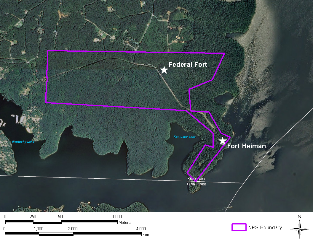
Figure 4:
Satellite imagery of the Fort Heiman unit of Fort Donelson National Battlefield
depicting the locations of the Federal Fort earthworks and the Fort Heiman
proper earthworks (imageryobtained from ESRI 2011).
Lowe described the earthworks at Fort Heiman proper,
which lies at the end of Fort Heiman Road and extends along the peninsula of
high ground of created by the impoundment of Kentucky Lake, as readily visible
and largely intact. The 2002 investigations
resulted in the mapping of some 593 meters (648 yards) of surviving military
earthworks, with slightly more than half rated as being in good or fair
condition. The rest of the earthworks
had been damaged during road construction, or perhaps by Union efforts to level
portions of the fort closest to the river following its capture in February
1862 (Jim Jobe, Fort Donelson Park Historian, personal communication 2010); a
shallow shelf behind the northernmost works that is incongruous with the rest
of the construction may be evidence of this destruction (Lowe 2002:2). Additionally, other portions of the northern
earthworks were subject to severe erosion (Lowe 2002:1).
All of the raised earthworks were found to have been constructed with a
rear ditch, save for a short portion which is ditched on both sides, and they
range in relief from 0.7 to approximately 2 meters (1-6 feet). Lowe noted that without further archaeological
investigation, it was impossible to determine the extents of the original
Confederate fort or the subsequent Federal defenses, though he suspects that
the northernmost earthworks represent a surviving segment of the original Fort
Heiman, due to its double-ditched construction that resembles other Confederate
designs, and apparent attempts to level the works (Lowe 2002:2). Additionally, Lowe mapped nine pits at the
north end of the site said to be former Union graves from which the human
remains were subsequently removed and reinterred at Shiloh National
Battlefield. Each pit measured six feet
long. Two were nine feet wide, two five
feet wide, and the remainder large enough for a single burial. A large rectangular hole strewn with old
firebricks is suspected to be the fort’s powder magazine (Lowe 2002).
The “Federal Fort,” so-named due to its comparable size and construction
to Federal forts found in Petersburg, Virginia, and other Tennessee River
garrison forts such as Johnsonville, sits just over 800 meters inland from Fort
Heiman proper. Lowe described the fort
as “an irregular redoubt designed to support 3 or 4 guns with an inner
perimeter (along the parapet) of 258 meters and an outer perimeter (outer edge
of the ditch) of 308 meters…[enclosing] 2,766 square meters” (2002:2). The fort was in good condition, to the point
where Lowe mapped two likely gun emplacements suited to command road access to
the northwest and southwest and a sally port in the northeast angle of the redoubt. However, some of the earthworks along the
northern face appear to have been purposefully damaged by vacating Federal
troops. Based on the presence of several
rectangular dugouts measuring approximately 4 meters square, Lowe suggested
that garrison camps may have been placed in the ravine to the southeast of the
fort.
New South Associates 2010
In September 2010, members of New South Associates conducted a
systematic metal detecting survey and shovel test survey of approximately 30
acres on the Fort Heiman proper landform (Tankersley and Gregory 2010). Over 500 artifacts were recovered during
metal detector survey. The majority
consisted of nails, screws, and spikes, and likely resulted from construction
both during and after the Civil War occupation.
No distinct patterns of nails could be determined, which may be due to
the area having been extremely disturbed by Civil War relic hunters and metal
detector enthusiasts. Ammunition finds
included a variety of types, including musket balls, pistol bullets, 0.58-0.69
caliber Minié balls, 0.50 caliber Gallagher carbine bullets, 0.54 caliber
Sharps carbine bullets, buck shot, a copper cartridge, and an artillery shell
fragment. Most of this assemblage
reflect munitions used in the early period of the war, when both Federal and
Confederate troops used similar weapons.
However, Tankersley and Gregory (2010) pointed out that Sharps’ carbine
bullets are typically associated with only Federal cavalry and naval units
(Thomas 2002), while the 0.50 caliber Gallagher was utilized by mounted troops
of both armies. These finds thus
represent the presence of both Confederate and Union cavalry during their
various occupations of Fort Heiman during the Civil War.
Southeast Archeological
Center 2010
Between November 27 and December 7, 2011, the
National Park Service Southeast Archeological Center conducted metal detecting
and shovel testing survey at the Fort Heiman Unit of Fort Donelson National
Battlefield, pursuant to the Park Service’s NHPA Section 110 obligations. Shovel tests were conducted along transects
at 20 meter intervals in areas of less than 20% slope. Metal detecting survey was conducted in areas
of greater slope, in addition to the area included in the shovel test survey. Research objectives included the location and
documentation of new archaeological sites and the mapping and assessment of
known landscape features. Ultimately,
the survey aimed to differentiate between Union and Confederate occupations of
Fort Heiman and to locate a documented but unfound African American Freedman’s
camps near the earthworks of Fort Heiman.
The SEAC survey was an unfortunate reminder
of the impact that relic hunters can have on Civil War landscapes (see
Tankersley and Gregory 2010), but enough material was recovered to provide a
general characterization of the area during the war. An area of 17 hectares (29.7 acres) was
intensively surveyed with metal detectors.
A total of 169 metal detector finds (MDETs ) were collected within the
surveyed area (Figure 5, Table 1). The
survey resulted in the recovery of 242 artifacts (in many cases, multiple
artifacts were recovered within each MDET).
Cut nails composed the overwhelming majority of the assemblage (n=172,
see Table 2). Two wrought nails were also
recovered as were two brass percussion caps, a fragment of canister shot, one
1856 silver half-dime, six musket balls, and six Minié balls (Table 3). Shovel testing resulted in the excavation of
156 tests to the depth of sterile soil or until bedrock was encountered and
further digging became impossible. A
total of 12.2 hectares (20.57 acres) were surveyed in this manner. Artifacts recovered during shovel testing
consisted primarily of non-diagnostic prehistoric lithic material. This material is beyond the scope of the
current paper, but further description of the prehistoric component of the area
including Fort Heiman can be found in Parsons 2011.
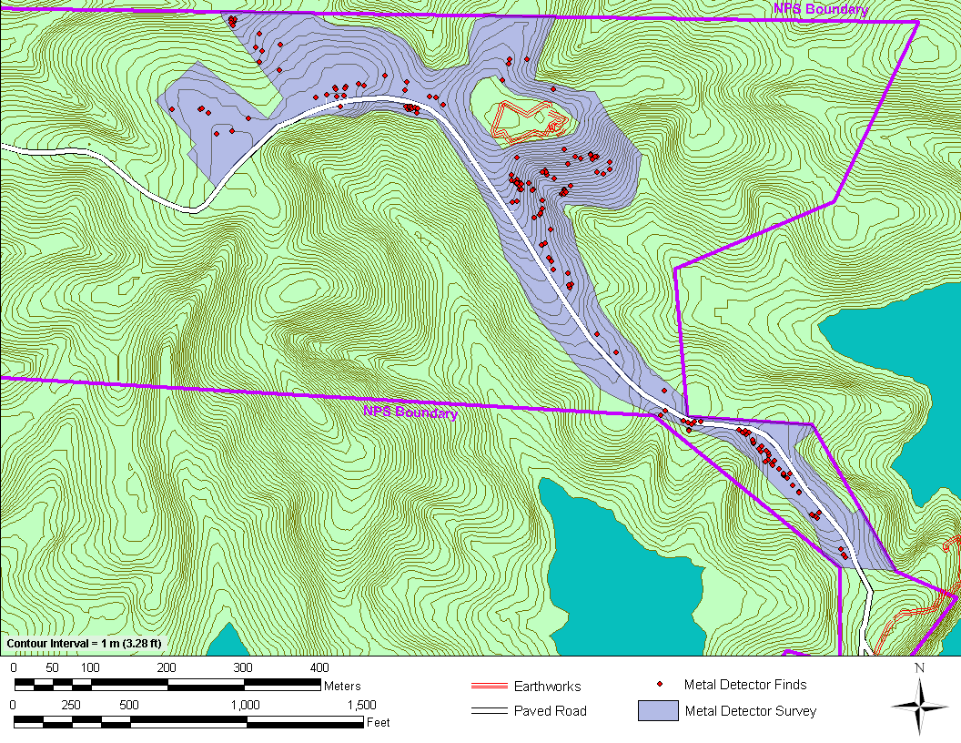
Figure 5: Map depicting the metal detector survey area
and locations of metal detector finds. Contours
obtained from USGS National Elevation Dataset (NED) 1/3-arc-second dataset
(2011).
Table 1. Summary of metal artifacts recovered from
Fort Heiman, Fort Donelson National Battlefield.
|
Metal Object |
Count |
Weight (g) |
|
Ball, Musket |
6 |
137.40 |
|
Bridle |
1 |
133.20 |
|
Buckle |
1 |
23.30 |
|
Bullet, Minié |
6 |
181.00 |
|
Can |
2 |
39.80 |
|
Cap, Percussion |
2 |
1.40 |
|
Coin |
1 |
1.20 |
|
Hardware |
5 |
359.70 |
|
Horseshoe |
13 |
2,522.80 |
|
Knife, Pocket |
1 |
43.10 |
|
Spark Plug |
1 |
11.40 |
|
Metal Fragment |
11 |
42.58 |
|
Nail, Cut |
172 |
601.47 |
|
Nail, Wrought |
2 |
7.50 |
|
Nail, Wire |
3 |
11.50 |
|
Nail, Ind. |
4 |
16.60 |
|
Ornament |
1 |
52.90 |
|
Pot |
1 |
86.50 |
|
Firearm mainspring |
1 |
23.90 |
|
Ring |
1 |
2.00 |
|
Screw |
2 |
21.90 |
|
Shell, Artillery |
2 |
65.20 |
|
Shot |
2 |
100.73 |
|
Spike |
9 |
163.70 |
|
Wire |
1 |
6.50 |
|
Total |
251 |
4,657.28 |
Table 2. Summary of nails recovered from Fort Heiman,
Fort Donelson National Battlefield.
|
Type |
Count |
Weight (g) |
|
Nail, Cut |
172 |
601.47 |
|
Nail, Wrought |
2 |
7.50 |
|
Nail, Wire |
3 |
17.90 |
|
Nail, Ind. |
4 |
10.20 |
|
Total |
181 |
637.07 |
STUDY
AREA
|
Munition
Type |
Caliber |
Condition |
Count |
|
Musket
Ball |
0.65 |
Unfired |
1 |
|
Musket
Ball |
0.65 |
Unfired |
1 |
|
Musket
Ball |
0.68 |
Unfired |
1 |
|
Musket
Ball |
0.50 |
Unfired |
1 |
|
Musket
Ball |
0.65 |
Unfired |
1 |
|
Musket
Ball |
0.68 |
Unfired |
1 |
|
Minié
Ball, three ring |
0.69 |
Unfired |
1 |
|
Sharps
carbine with tie ring base |
0.52 |
Fired |
1 |
|
Carved
Enfield bullet |
0.69 |
Unfired |
1 |
|
Minié
Ball, three ring ogival |
0.57 |
Unfired |
1 |
|
Minié
Ball, three ring concave |
0.60 |
Fired |
1 |
|
Minié
Ball, three ring ogival |
ind. |
Fired |
1 |
|
Artillery
Shell |
ind. |
Fired |
2 |
|
Shot,
iron (buckshot) |
1.20 |
ind. |
1 |
|
Shot,
lead (canister shot) |
ind. |
ind. |
1 |
|
Total |
16 |
In
addition to the artifacts described above, previously undocumented features of
the cultural landscape were encountered during the course of the survey. These include previously undocumented
earthworks, segments of historic road traces, and hut pads dug into the face of
the slope near the Federal Fort. Although portions of the historic roads and
road traces were previously mapped by Lowe (2002), they deserve mention here
because of their association with both the Federal Fort and newly documented
earthworks. Each of these will be discussed
in turn.
Earthworks
Three sections of previously undocumented
earthworks were recorded during the course of SEAC field investigations at Fort
Heiman (Figure 6). The first runs for 55
m (180 ft) paralleling Fort Heiman Road approximately 350 m (1,150 ft)
southeast of the Federal Fort, and has suffered from heavy erosion. The second earthwork sits 230 m (750 ft) due
east of the Federal Fort, and for a distance of 100 m (330 ft) roughly
parallels a historic road trace (see below) that follows a hollow leading
toward the Tennessee River. This appears
to be a double row of earthworks, and has also been negatively impacted by
heavy erosion. The third earthwork is located
roughly 350 m (1,150 ft) northwest of the Federal Fort on a relatively flat
area (less than 10% slope) and runs 115 m (375 ft) southeast to northwest, then
turns at a right angle to the northeast and runs a further 40 m (130 ft). The feature is dug out on either side and
mounded in the middle. These works have
not been as negatively impacted by erosion as the others, and while low in
relief in some places are approximately 1.2 m (four ft) high at their tallest
point.
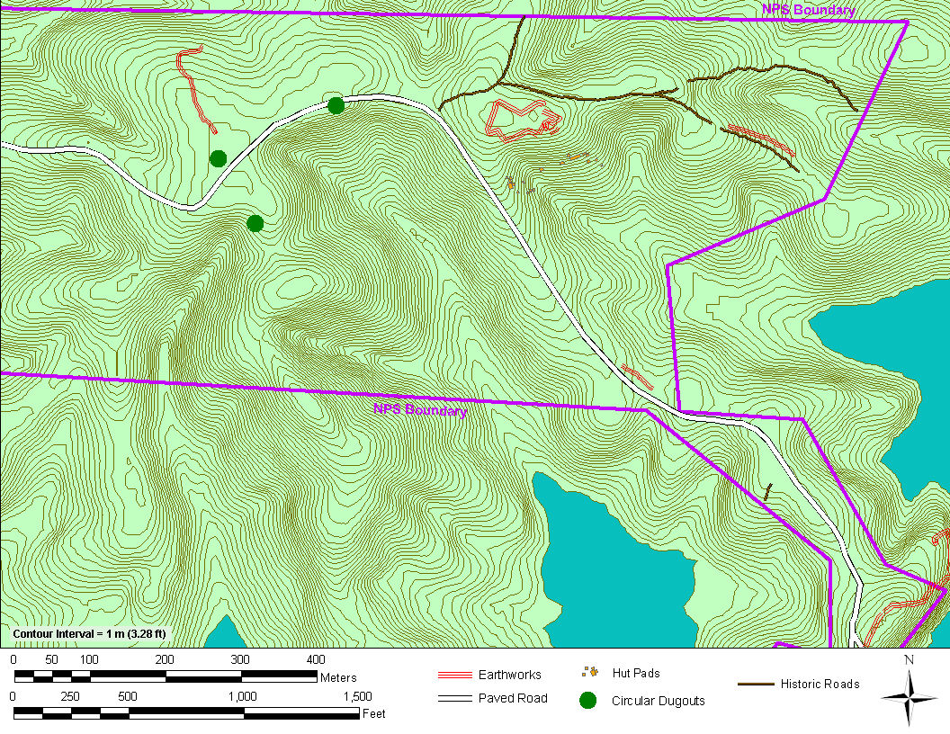
Figure 6: Map depicting the locations of mapped
earthworks at Fort Heiman, along with historic roads. The indicated circular dugouts are of unknown
origin, but appear to be associated with a nearby 20th century
homestead. Contours obtained from USGS National Elevation
Dataset (NED) 1/3-arc-second dataset (2011).
No artifact concentrations are associated
with any of these earthworks. However,
the roughly central position of the Federal Fort in relation to the earthworks
and their distance from the Confederate Fort Heiman proper suggests that the
newly documented features are a component of the Union occupation.
Historic
Roads
Previously discussed by Lowe (2002), several
historic roads and road traces are associated with the Civil War component of
the Fort Heiman Unit. They were remapped
as part of the SEAC survey due to their proximity to known earthworks, and
their various spatial associations with sections of the previously undocumented
earthworks described above (Figure 6).
Lowe (2002:2) specifically mentions an “Old Wagon Road” that diverges
from Fort Heiman Road, runs east past the northern earthworks of the Federal
Fort, then turns slightly south running through a hollow to the shoreline
(culminating historically at the river landing). This road roughly maintains a 5% grade, and
is the most well defined of several road traces in the area observed previously
by Lowe and more recently by the SEAC survey team. Furthermore, a portion of this road between
the Federal Fort and the river parallels a segment of previously undocumented
historic earthworks.
Hut
Pads
Several rows of hut pads were located
approximately 100 m (330 ft) to the south-southeast of the Federal Fort (Figure
7). Hut pads are flat areas formed from
the side of a slope that serve as platforms for tents, huts, or other
structures. A total of 19 hut pads were
measured and mapped during survey. The
rectangular hut pads are generally between 2.50-4 m2 (8-13 ft2)
in size and dug into the side of the slope to create a flat surface. Some of the measured hut pads were much
larger (approximately 14 m wide by 4 m deep, or 46 by 13 ft) and are
interpreted as hut rows where multiple tents or structures would have been
placed in a line. Undoubtedly, more hut
pads would have been created and utilized during the occupation period of the
fort; unfortunately, however, the slope on which the hut pads were placed has
been subject to erosion, and a thick leafy overburden covers the hillside,
making subtle landscape modifications difficult to observe. A rough spatial correspondence between cut
nails and hut pads exists. Several of
the features were initially located upon excavating metal detector hits and the
discovery of cut nails, while others were visually identified during the course
of survey.
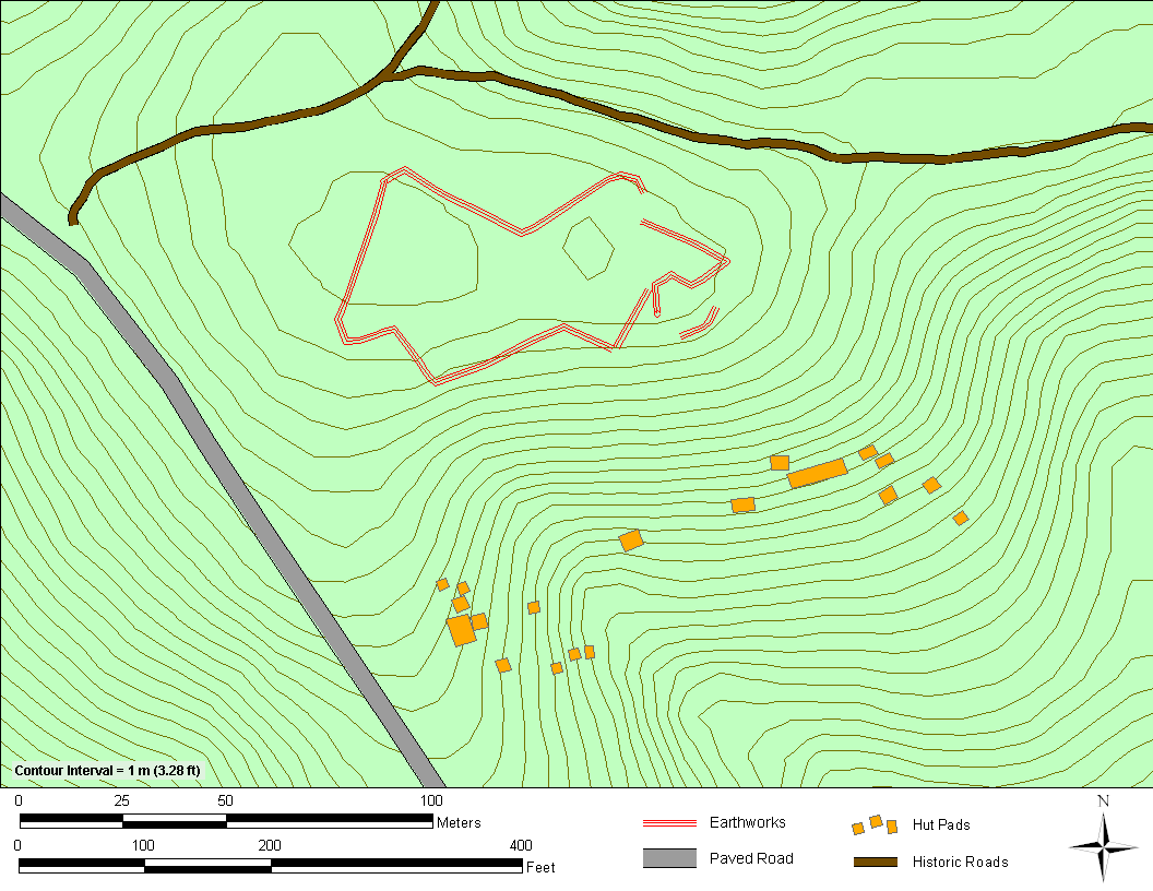
Figure 7: Map depicting the locations of mapped hut pads
on the hill slope south of the Federal Fort earthworks. Contours obtained from USGS National Elevation
Dataset (NED) 1/3-arc-second dataset (2011).
Discussion
and Conclusions
Of the historic artifacts recovered by SEAC investigators at Fort
Heiman, only material dating to around the time of the Civil War was numerous
enough to warrant detailed interpretation.
This is unsurprising, as Union and Confederate forces intensively and
almost continuously occupied the area between 1861 and 1865, and since that
time the entire area has remained relatively undeveloped. Unfortunately, as Tankersley and Gregory
(2010) have discussed in detail, there has been a significant impact on the Civil
War component of the site by metal detecting relic hunters, and it is likely
that a great deal of material and information is irrecoverably lost.
The most frequently encountered artifacts—machine cut nails—could have
resulted from building activities associated with the various occupations of
the fort. The same can be said for the
variety of screws, spikes, and other metal hardware recovered during metal
detecting survey. Clusters of nails were
found associated with the rectangular earthen platforms interpreted as hut
pads, although no distinct patterns in nail locations suggested structural
footprints. Tents or other small
structures that served as quarters for soldiers at the fort would likely have
been placed on top of these flat areas.
Bergeman (2004:49) described these huts as variously sized buildings
crudely constructed of scavenged materials from building ruins in the
area. This interpretation is supported
by the presence of an 1854 half dime (Figure 8) and four unfired (dropped)
musket balls (Figure 9) the recovered from the area.
![]()
Figure 8. Obverse and reverse of
a United States 1854 Seated Liberty half dime recovered during metal detecting
survey in the area of the hut pads south of the Federal Fort earthworks.
![]()
Figure 9. Buckshot and musket balls from the Fort
Heiman Unit: a. Lead buckshot, b. 0.50 caliber musket ball, c. 0.65 caliber
musket ball, d. 0.65 caliber musket ball, e. 0.68 caliber musket ball, f. 0.68
caliber musket ball, g. 0.65 caliber musket ball.
Unfortunately, the munitions assemblage recovered during metal detecting
survey did not provide much information regarding use areas, or different areas
of Confederate and Union occupation.
Since the immediate area around Fort Heiman did not witness any
significant engagements between opposing forces, this is not a surprise. The musket balls and Minié balls recovered
during the investigation are associated with muskets and rifles used by both
sides during the early phases of the War, though the 0.52 caliber Sharps
carbine tie-end bullet is often associated with Union cavalry (Figure 10). This is not definitive, however, as
Confederate cavalry were also known to use captured Sharps carbines.
![]()
Figure 10. Minié balls from the Fort Heiman Unit: a.
0.60 caliber unfired, b. Ind. Cal 3 ring fired, c. 0.57 caliber unfired, d.
0.69 caliber unfired, e. 0.69 caliber carved Enfield, f. 0.52 caliber fired
Sharps tie-end.
Since the diagnostic munitions recovered during the investigation were
of kinds used by both Union and Confederate forces during the Civil War, it is
difficult to determine which side left the most significant footprint on the
landscape. This difficulty is
exacerbated by the fact that the area changed hands multiple times during the war,
beginning in 1861 with the Union victory at the battles of Fort Henry and Fort
Donelson. However, based on the design
of the Federal Fort and the known history of occupation, both Lowe (2002) and
Bergeman (2004:49) attributed these earthworks to the Union Fifth Iowa Cavalry
occupation between 1861 and 1863, both having noted that the Confederate works
on the Fort Heiman peninsula were minimal and incomplete at the time of Union
arrival. It is therefore likely that the
newly documented earthworks to the northwest of Fort Heiman proper were also
constructed during the two year Union occupation.
Though Confederate cavalry under Nathan Bedford Forrest reoccupied Fort
Heiman in October 1864, approximately one year after Union forces left their
tumultuous two year post, SEAC investigations did not discover any material
evidence directly related to Forrest’s occupation. This chapter in the history of Fort Heiman is
perhaps one of the most provocative, since Forrest’s cavalry led raids
throughout western Tennessee and eventually attacked a Union supply depot in
Jackson, Tennessee. During this
campaign, Forrest captured several Union vessels on the Tennessee River and
temporarily blockaded it to Union supply traffic.
Although further archaeological research could provide evidence
specifically addressing each of the Union and Confederate occupations of the
Fort Heiman area, two factors may complicate future research. First, the significant impact of relic hunters
on the area’s archaeological record is unfortunate and undeniable (see
Tankersley and Gregory 2010, Appendix B).
Second, both the SEAC and New South Associates investigations of the
Fort Heiman Unit recovered Civil War materials utilized by both sides during
the early phases of the War. This makes
distinguishing items left behind during the various occupations difficult. However, more directed archaeological
research toward specific features on the landscape would be worthwhile. For example, systematic excavation of one or
more of the recently discovered hut pads could definitively determine if they
were constructed by Union or Confederate forces, and may thus shed more light
on their specific period of use and confirm their actual function.
No evidence of a Freedmen’s camp was discovered during the
investigation. In identifying such a
component on the landscape, archeologists might reasonably expect to find
common household items such as dishes, pots, pans, and so on, as evidence of a
non-military settlement near the fort, though an archaeological signature is
difficult to characterize with any certainty since no camps in the area have
been investigated archaeological.
Furthermore, very little historical documentation exists discussing the
Freedmen’s settlement, and nothing has been recorded indicating the location of
the settlement in relation to either Fort Heiman proper or the Federal
Fort.
Acknowledgements
This paper was presented at the 68th annual Southeastern
Archaeological Conference meeting, and resulted from the combined efforts of
National Park Service archaeologists Dr. Timothy Parsons, Dr. Guy Prentice, and
Dr. Meredith Hardy, who cumulatively produced a much larger research report on
the Civil War story of the Fort Heiman unit of Fort Donelson National
Battlefield and the prehistory of southwestern Kentucky. SEAC archeologist Julia Byrd provided
thoughtful revisions to the draft of this paper. Credit is also due to Jessica McNeil, the Principal
Investigator of the Fort Heiman field investigation, and Michael Seibert and Hayley
Singleton who along with the author comprised the field crew. Two volunteers, Kevin Wells and Mark Owens,
provided their metal detecting expertise to the project. Special thanks go to the staff of Fort
Donelson National Battlefield for their expertise and cooperation, especially
Superintendent Steven McCoy and park historian Jim Jobe for their help in
ironing out the finer details of the battles of Fort Henry and Fort
Donelson.
References Cited
Baker, Nathaniel B.
1863
Report of the Adjutant General and Acting Quartermaster General of
Iowa, In Accordance with the Laws of the State, To Hon. Samuel J. Kirkwood,
Governor of Iowa, by Nathaniel B. Baker, Adjutant General and Acting Quarter
Master General, January 1, 1863, Vol. II.
F. W. Palmer, State Printer, Des Moines, IA.
Bergeman, Kurt D.
2004
The Minnesota Cavalry in the Civil War and Dakota War. Borealis
Books, St. Paul, MN.
Cimprich, John
1985
Slavery’s End in Tennessee. The
University of Alabama Press, Tuscaloosa.
Cooling, Benjamin
Franklin
1987
Fort Donelson’s Legacy: War and Society in Kentucky and Tennessee,
1862-1863. The University of
Tennessee Press, Knoxville.
Eisterhold, John
A.
1974
Fort Heiman: Forgotten Fortress. The
West Tennessee Historical Society Papers 38.
Foote, A.H.
1882
Reports Report of Flag Officer A.H. Foote, U.S. Navy, of Engagement
February 14. In United States
Congressional Serial Set, 47th Congress, 1st Session. Government Printing Office, 1882.
Force, Manning
Ferguson
1881
From Fort Henry to Corinth. Charles Scribner’s Sons, New
York.
Gott, Kendall T.
2003
Where the South Lost the War: An Analysis of the Fort Henry-Fort
Donelson Campaign, February 1862. Stackpole
Books, Mechanicsburg, PA.
Harrison, Lowell
H., and James C. Klotter
1975
The Civil War in Kentucky.
The University Press of Kentucky, Lexington.
Hawkins, Susan
2002
The African-American Experience at Forts Henry, Heiman, and Donelson. Tennessee Historical Quarterly 61(4):222-241.
Hays, William T.
1865
Reports and Histories. Fifth Cavalry. History of the Regiment. In Report of the Adjutant General and
Acting Quartermaster General of the State of Iowa, January 11, 1864 to January
1, 1865, pp. 977-1010. F. W. Palmer,
State Printer, Des Moines, IA.
Heiman, A.
1882
Report of Col. A. Heiman, Tenth Tennessee Infantry. In United States Congressional Serial Set,
47th Congress, 1st Session. Government Printing Office,
1882.
Howard, Victor B.
1982
The Civil War in Kentucky: The Slave Claims His Freedom. The Journal of Negro History
67(3):245-256.
Jobe, Jim
2010 Personal
Communication. Fort Donelson National
Battlefield Park Historian. Regarding
the construction of earthworks at the Fort Heiman Unit of Fort Donelson
National Battlefield.
Lampley, Dennis Joe
2008
Adolphus Heiman, a Brief Biography.
Powder and Lead Newsletter 1(5):1-3.
Lowe, David W.
2002
Fort Heiman and Fort Henry GPS Survey, June 2002. Cultural Resources GIS, National Park
Service.
McClernand, John.
A.
1882
Reports of General John Alexander McClernand, U.S. Army. In United States Congressional Serial Set,
47th Congress, 1st Session. Government Printing Office, 1882.
McPherson, James B.
1882
Reports of Lieut. Col. James B. McPherson, U.S. Army, Chief
Engineer. In United States
Congressional Serial Set, 47th Congress, 1st Session. Government Printing Office, 1882.
Morton, Julius S.
and Albert Watkins
1918
History of Nebraska from the Earliest Explorations of the
trans-Mississippi. Western
Publishing and Engraving Company, Lincoln, NE.
Potter, James E.
1993
A Nebraska Cavalryman in Dixie: The Letters of Martin Stowell. Nebraska History 74:22-31.
Tankersley, Wm.
Matthew, and Danny Gregory
2010
Archaeological Characterization of the Fort Heiman Landform,
Calloway, Kentucky. New South Associates,
Technical Report 1940, Stone Mountain, Georgia.
Thomas, D.S.
2002
Round Ball to Rimfire: A
History of Civil War Small Arms Ammunition: Part One. Thomas Publications,
Gettysburg, PA.
Tilghman,
Lloyd
1882
Reports of Brig. Gen. Lloyd Tilghman, C.S. Army, commanding Fort
Henry. In United States Congressional
Serial Set, 47th Congress, 1st Session. Government
Printing Office, 1882.
United
States War Department
1882
The War of the Rebellion: A Compilation of the Official Records of
the Union and Confederate Armies. Vol.
7. Government Printing Office,
Washington.