Landscape
Change in the Inner
R. Berle Clay
Abstract
A “Southern rural Whig
ideal” is suggested to describe a settlement pattern that developed in the
early nineteenth century in a series of adjoining farms in the Inner Bluegrass
Region of central
Contrasts
The 1860 Hewitt wall map of central
Kentucky was adorned with marginal engravings depicting public buildings with
two exceptions. These were views of
Brutus Clay’s farm, three miles from the Bourbon County court house seat of
Paris. They were there because of the
importance of the man as a successful farmer in an age when the agricultural
life set the tone for society. Quite
possibly, Brutus, as I shall call him, paid for the engravings and for the
honor of having them displayed on the wall map for with them he was making a
political statement as well.
Despite their prominence, these
illustrations are in a sense ambiguous and their ambiguity is a clue to the
values and ideals of not only Brutus but the rural community in which he
lived. The first is the head-on view of
his house built in 1837 (Langsam and Johnson 1985:182-183) (Figure 1). The point of this illustration is rather
evenly divided between several features, importantly the bull to the left, and,
in the center, an elaborate cast iron porch which Brutus installed the year
before in preparation for his daughter’s marriage.
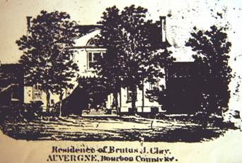 |
Figure 1. Brutus Clay’s residence, marginal
illustration of Hewitt Map, 1860. |
But this view of an elaborate house hardly gives one
an accurate impression of its size or complexity (Riesenweber and Hudson
1990:29-44). It is a transitional, two-story
double pile, center hallway structure of generous dimensions with a distinctive
and stylish (for the time) pediment framing the entrance. With flanking one story wings and an
extensive back house with kitchen and work rooms, and well built brick
outbuildings, it was at the time of its construction the largest house in the
county. Even trees dull the impact of
the central mass. The picture, then, is
perhaps a half-hearted attempt to impress the viewer with the total complex, rather
it focuses on some recent details like the bull and the porch. As a contemporary photograph illustrates
(Figure 2), the general effect fortunately has been preserved although the bull
has been replaced by more modern symbols.
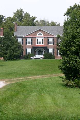 |
Figure 2. Contemporary view of Brutus Clay’s home. |
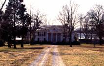
In the second image (Figure 3),
which is even more ambiguous, the homestead is seen from a distance. True, there are cows, colts, and prancing
horses with riders, but any structure is carefully disguised. For a man who was a noted farmer, president
of both the county and state
Agricultural Societies (Hood 1977:214), one gets little feeling from this
picture that the man was engaged in farming.
Nor is the landscape highly ordered.
Just what was the point of the
illustration?
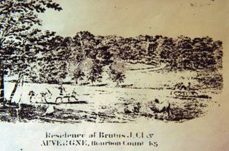 |
Figure 3. View of Brutus Clay’s Farm,
marginal illustration from Hewitt Map, 1860. |
A contemporary photograph (Figure 4)
indicates, again, that the effect of this view has fortunately survived, as
ambiguous as ever. However, the
intentional coyness of the nineteenth century view is emphasized when the
modern photographer moves about 100 feet to the west as the earlier illustrator
could have done and redefines the view with a head-on view of the house. This bucolic scene then easily resolves into
an elaborate built environment, dominated by Brutus’ not-so-humble house which
faces south for warmth in the winter. In
the understatement of these two marginalia Brutus makes an important political
statement. True, the man was wealthier
than many of his neighbors -- he was for example in 1860 the largest slave
owner by far in the county -- and he could build more elaborately. But in what amounts to a considerable
reticence, even where he had wealth to flaunt, and in an ability to focus on
details at the expense of the whole, he is expressing a local world view which
cross-cut economic class. This might
aptly be called the Southern rural Whig frame of mind.
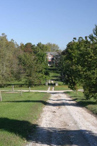 |
Figure 4. Contemporary view from
entrance road. |
The scale of the homestead is
evident from air photos (Figure 5).
Considering the fields and lots which were enclosed by rock fences, it
is quite large. Scattered around are the
structural elements which combined made the diversified live stock and crop
farming enterprise which was so successful for the decade of the 1850s. Defined on the northeast by a cemetery
dedicated to the African American bondsmen and their families, on the southeast
by a large pond specifically built as an ice source for a generous ice house, on
the southwest a cow lot with its cow barn and a bull lot, and beyond it a large
quarters on the northeast, the total complex is nearly a half mile on the
diagonal.
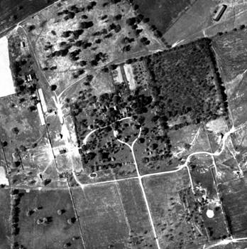 |
Figure
5. Brutus’ homestead from the air. |
Two period photos also indicate the
nature of the homestead which amounts to a series of “field barns” and not an
articulated set of buildings, and so they have been remembered. The first view is of the eastern side of the
complex taken about 1910 (Figure 6), showing in the center a threshing barn
built in 1841 and centered in a fold yard known as the “cutting up barn
lot”. To the left is the “jack barn” in
the “jack lot”, probably built in the 1830s.
Just off the picture to the left was a mill complex built in 1831 which
contained a horse powered sash saw and grist mill. In the background is a thicket which is in
fact the remains of an extensive orchard planted in the early 1850s.
 |
Figure 6. Eastern end of homestead: threshing barn on
right, Jack barn on the left, orchard in the background (photo c 1910). |
The second photograph (Figure 7), of
the core of the “lots” or the center of farm activities west of the house,
focuses on a young man, Hamp Ayres Jr..
He holds an armful of corn which he has just obtained from a log crib
built in 1813. To one side is a one-room
domestic structure, probably built for slaves in the 1840s. In the distance is a quarter, built as early
as 1813, still surviving at the date of the photo which is about 1895. One is impressed in both pictures with the
highly dispersed nature of the components of this built environment.
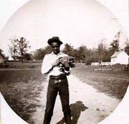 |
Figure 7. Hamp Ayers Jr. in the “lots,” one-room house
on right, corn crib on the left, “quarters” in the background on the left
(photo c 1895). |
Concluding this brief survey of a
large, complex, dispersed homestead, it must also be realized that the
structures, when built, were literally “in the woods.” The complex was nearly two miles from the
nearest public trace, tucked away at one end of a long rectangular tract of
land which Brutus’ father, Green Clay, obtained in 1782 from Virginia. Elaborate as the house may have been, it was
built literally shielded from public view by virgin forest. Even today it is a mile from the nearest
public thoroughfare.
As he was planning to build, Brutus’
mother specifically warned him to build with moderation (Sally Clay to Brutus
Clay 1837, Clay Papers, University of Kentucky Library)....”you have no idea of the expense of
furnishing and keeping so large a house clean.
In your retired situation you might not have company in seven years to
fill it....with my experience in those things I would not have a house as large
as you intend to build....... She
sadly concluded, “....... I am sure that
my advice is good (and) that you will
then do as you please”.......which he did!
Contrast this farmstead with the
adjoining one (Figure 8) built in 1865 by Brutus’ neighbor and distant relative,
Samuel Clay, at the close of the Civil War, paid for by financial success at
selling farm products to the Union armies.
The illustration of the house, called Marchmont (Langsam and Johnson
1985:180-181), was a centerpiece in a history of Bourbon County published in
1882 (Perrin 1882), itself a typical product of the times, in which,
interestingly, there no mention, let alone illustration, of Brutus’ elaborate
structure just two miles away!
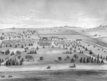 |
Figure 8. Marchmont, Brutus’ neighboring homestead
built 1866 (Perrin 1882:43). |
Built on the public road, Marchmont was
placed to be seen (Figure 9) and from the birds-eye perspective we immediately
comprehend it in all its complexity for the parts are highly articulated and anchored
to the public byway by dual entrances and a semi-lunate approach drive. Significantly, Samuel faced his house west to
the nearby road, not south as had Brutus, despite the fact that this exposed it
to the full force of the prevailing weather.
There is none of the ambiguity of the earlier illustrations of Brutus’
home. Interestingly the view does retains a tie to the past: in the
distance on the left is pictured the house of Samuel’s deceased father, a
relatively simple brick “I” house, like Brutus’ built about 1820 far from any
trace, in the middle of the man’s farm tract and facing south. Samuel, however,
has moved considerably beyond these relatively simple beginnings. He too makes a political statement, but by
comparison it is a whopper, quite different from the restrained one made less
than twenty years before by his slightly older neighbor, Brutus. It is probable that Samuel, like Brutus, paid
for the artist’s rendering for inclusion in Perrin’s county history. It is also quite possible that Brutus, by
then elderly, refused to pay for an illustration of his, thus its omission.
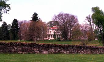 |
Figure 9. Marchmont viewed from the turnpike, a
contemporary photo. |
From the air this new Marchmont complex
is revealed as much more compact. All
structures associated with the operation of this farm are concentrated around
the main house and all are there for the world to assess as they ride by. But beyond recording the achievements of this
particular farmer in the hog and mule trade, the view of Marchmont is
indicative of a general shift in comprehension of the rural community which
occurred between circa 1837 when Brutus built his house and 1882 when the
county history was published.
While Hewitt’s 1860 wall map
illustrated only one rural homestead (the rest were commercial establishments
and public buildings), Perrin’s (1882) publication is replete with them, all
seen from a birds-eye perspective emphasizing the relationship of the house to
the road. Other homesteads in this
neighborhood were similarly changed during the years after the war, if not with
radical reconstruction, then with additive construction, whose end goal was to
align the facade of the domestic context with the road so all could see
it. Along with this, outbuildings were
drawn together to cluster around the home itself.
This phenomenon of rural structural
reorientation has been noted widely, perhaps most forcefully in New England,
and related in a general way to “modernization.” In his classic study of the connected barn of
the New England farm, Thomas Hubka (1984) has charted how, in the years between
roughly 1760 and 1830, houses were shifted from a generally southern
orientation to face the road. As a very
general statement he relates this shift to the increasing commercial importance
of the town over the countryside in the lives of New England farmers. In one area of New England this ultimately
led to the physical rearrangement of existing buildings and their consolidation
into the New England connected structure (big house, little house, back house,
barn). In each part of the country the
timing of the change and the actual reasons for its occurrence differed. For Brutus’ world in rural Bourbon County in
the nineteenth century there was a particular set of circumstances which
dictated the stages in “modernization” through the century.
Lewis F. Allen’s Vision and Historical
Causes
Writing in 1844, the New York State
agricultural journalist Lewis F. Allen, author of Rural Architecture (1852), contrasted styles of rural settlement in
the country at the time:
"Your
true Southerner, and Pennsylvanian, and South Western farmer, nestles down
simply in a convenient spot on his estate; let the traveled highway go where it
may, and there he awaits the call of the public, attending solely to his own
domestic affairs, content to see what comes upon him, hieing out from his
domcil (sic) when occasion demands it: while your inquiring Yankee as universally
plants himself on the main road, determined to see everything as it passes, and
dreading nothing so much as to be shut out from the gaze of the passer by, and
not to know as it occurs, everything of public import as well as private rumor."
He
followed with specific advice to the Southern farmer:
"Were
I to locate my buildings on the farm, proximity to the road would have little
influence on my choice. Access to good
water, a central position on the farm, by which every part of it might be
easily reached in getting in the crops and superintending the labor would be
the main object; while the passing on the highways and the neighborhood gossip
would be the last requisites I should consult."
Allen was a correspondent of Brutus Clay’s
and they shared a common interest in blooded Durham cattle. Brutus’ large stock barn built in 1856
followed, in a general way, Allen’s plans of his own barn in New York state (Allen
1952:299). It is even possible that
Allen visited the Kentucky Bluegrass, authoring a series of sketches of the
rural scene for the Country Gentleman, one of which “A visit to the Bourbons,”
was an actual visit to Clay’s farm presenting it as a classic example of
Allen’s 1844 characterization of the southern farm. Brutus’ establishment was isolated, and this immediately
impressed visitors. But then, and this
is important to remember, so were the less elaborate homes of his neighbors.
Still, Brutus and Lewis Allen were clearly of the same frame of mind when it
came to rural planning.
While some have suggested (McMurry
1988:45-46) that Allen’s hyperbole is principally an example of a “progressive
agriculturist” rhetoric which developed in the first half of the century, there
were good historical reasons for the Kentucky settlement pattern which
impressed Allen and produced Clay’s homestead.
The pre-war homestead pattern here in Kentucky was as much conservative
as it was progressive, stemming from the manner in which land ownership was
taken up in the late eighteenth century.
The opening of the Virginia Land Office to accept land surveys west of
the mountains in Kentucky initiated a chaotic method of survey by metes and
bounds which, in due time and in reaction, would result in Jefferson’s drastic
modifications of public survey in the Northwest Ordinance in 1785
(Price:1995:190-192, Hammon 1980). By
1783 literally all the land in a county like Bourbon had been taken up by early
claims. Many of these bore little
relationship to “existing” claims.
Rather, early land surveyors literally shingled the countryside with
deliberately overlapping land surveys in the hopes that, by these efforts, they
could lay claim to some piece of land which had not already been alienated.
As result, land was not divided up
so as to be accessible to the roads: communication was largely coincidental to
the surveyed tracts and in fact roads really did not exist. The process of taking up land, and defending
one’s title against all comers, was a process of building upon these far-flung
parcels. This meant that the first
constructions in the wilderness were often widely separated. Such was the case of Brutus’ farming
neighborhood. Although his house was one
of the last to be built, he was following his father’s earlier improvements of
log cabin and crib, built as early as 1813 in utter isolation. Around his home were other early farms
likewise in similar isolation; the homesteads of Richard Clay, the Martins,
Thomas Duncan (Langsam and Johnson 1985:150), Thomas Kennedy (Langsam and
Johnson 1985:181-182) and Daniel Bedinger (Lamgsam and Johnson 1985:183-184),
all of which would be bought up as Brutus expanded his farm in the post-Civil
War era. The dispersed pattern which Allen noted was powerfully a product of
this simple factor.
But beyond its role in the seemingly
random placement of improvement homesteads, the early surveying methods laid an
indelible imprint on the lives of the first settlers which persisted for at
least several generations and was at the root of the Whig “idea.” Land was by no means freely available to all
who desired it. Rather it was the prize
for those with the wealth and connections to make the claim and the energy to
defend them. Land ownership produced an
instant class structure, creating a class contrast between land owners and landless. But the practice of preemption (the right to
take up land by clearing in addition to one’s purchased tract) rapidly made even
the small landowner into the land speculator (Aron 1992) and Turner’s “frontier
thesis” (Turner 1992 reprint) must be tempered with this realization. Despite the fact that there would always be
landless pioneers, for large and small landowners, land ownership, even land
speculation, rapidly became a value which cross-cut rich and poor --if you
owned land, you tended to think the same way about it, despite how much land
you might own.
Given this fact, although the homesteads
which might be built were isolated, the act of surveying land which preceded
their construction was an explicitly political act in which the community
participated. Similarly, the defense of
a land claim could be a drama worked out on the surveyed lines serving as the
court of public opinion, if not actually a court of law (although Kentucky was
famous for its land disputes which were common fare in the court system for the
first thirty years of the noneteenth century).
Two generations after initial discovery, land claims were still being
debated in Kentucky.
For example, when deposed by the
court on the details surrounding an early land survey in Madison County
(probably made during the 1780s), Brutus’ father, Green Clay, a highly
successful surveyor, answered as follows (Dorris 1945:339):
Q. - How many persons were along at the
time said survey was made?
A. - When James Estills (sic) preemption
was surveyed as well as my memory now serves me I think there about 7 or 8 men
along or perhaps more at different parts of the survey but I do not recollect
that the whole company went all around the survey but am rather inclined to
think they did not.....
The survey of this preemption was
clearly a public event. Years later,
succeeding generations would similarly survey their land before the public
eye. The fact of land survey was to
become a central political act, identified with the homestead ethic itself, for
the Kentucky farmer who hoped to establish a home, prosper on the frontier, and
leave his widow and children with the resources to continue their hard-won
prosperity. Settling his father’s estate
after Green’s death in 1828, Brutus was intimately involved in surveying lands,
establishing claims, and defending existing claims when necessary. In 1831 his brother-in-law J. Speed Smith
advised him of the tension occasioned by one such survey of lands which Brutus
had sold William Pearson in Estill County (Smith to Clay Apr.14, 1831, Clay
Papers, University of Kentucky Library):
Oakly
April
14, 1931
Dr. Sir,
Wm. Pearson came to see me a few
nights since, upon the subject of the land he purchased from you in
Estill. Kelly (***son) and Bob Asbile
claim part of Pearson's purchase and have had a survey made by the surveyor of
Clark and not surveying to your corners as marked, but stopping at the end of
the distnce (sic) called for in your *** that you do not cover the ground. I am told that three of your corners are
standing and can be shown and proved - if so, by projecting the side and end lines,
the point of intersection, will give you the lost corner. Pearson has behaved well, for he has laid a
warrant on the land which seemed to be left out of your claim by *** the
distance called for and was at Campbell's not more than twenty minutes before
Asbile was there for the same purpose.
The *** of laying out a warrant will be much better than a law
suit. He did so, after advice, for your
benefit. There were two cabbins (sic)
on the land, ** * a family of *** his son
is in one and hung up a blanket, by way of protection, *** the other. I told him by all means to keep his negroes
in the one and burn down (emphasis in text) the other, so as to give them no means of entering. He wishes much to see you at court and take
with you *** paper having reference to your title. I told him not to yield an inch and that you
would back him.
This latter day excursion into the
act of land survey links the act of delineation with the second crucial act,
that of actually building on the delineated claim. The construction of a shelter, however
simple, was viewed as an act of staking out a claim. In this instance the discovery of “two
cabbins” on the land poses an immediate threat to the new owner (who had just
bought the tract from Brutus). The
advice, to “put his negroes in the one and burn
down the other” is a clear statement to fill one with your people and
destroy the other.
This ritual of occupancy, in itself
also responsible for the dispersed early homesteads, runs as a constant theme
through the first 30 years of the nineteenth century. Again, Brutus’s family papers provide
impressive examples. In his memoranda
book, circa 1803-1805, Green made the following note for himself (GC “Memo
Book”): “..........a tennant (sic) should be settled on each tract of land
& his lease should be RECORDED (emphasis in the original).”
Occupancy, so it seems, could be
accomplished by the owner’s tenant, as well as the owner himself. The critical point, whether it be
accomplished with a public demonstration of moving on to the land and building
one’s self a house, or a house filled with your slaves, or merely through
getting a lease for the individual one happened to find having built on your
property, was to get the act of “occupancy” recorded for all the public to see.
One final note indicates how the
initial generation of settlers passed on the significance of this political act
is seen clearly from Green’s letter to Brutus’ elder brother, Sydney, when he
left home to look after his father’s affairs in Western Kentucky at age 22. Green had the following advice which he made
about as strongly as he could
(Green
Clay to Sydney Clay Apr. 4, 1822 Filson Club Collections):
I
want you to ride all over my land see who have settled on it since I left there
& give them leases on the best terms you can from 7 to 10 years git (sic) all the
tennants (sic) you can
everywhere. Don’t miss
one if possible that you can git (sic). Shew (sic) my patents where you go if need be.
But
your principle business will be to examine (by) what offices surveys are
made on my land & where and in whose name, the amount of acres- git all the
information you can on that *** write to me all these things once in every two
weeks.......There is three leases at the clerks office in Salem left there to
be recorded. Git (sic) them out and bring home & all those that
Thos. Jarrett and Jno. Martin gave.........
My
son Sidney, you are to proceed to the Tennessee lands and give all the leases
you possibly can, never loose a tenant (sic) if you can help it, give from seven to ten
years, the shorter the better for us, never have a lease less than 2 years six
is better......
Run
& remark the south line of Jn. Mayos 17,000 and the next line north from
his SSW corner to the next corner and measure both with the chain run by the
compass and find the next corner if possible.
Cut GC on three or 4 trees at each corner.....appoint one agent on each
of the other tracts and give them a part of the blank leases: request them in
the strongest terms to write me once a month......
Go
and see the corner I shewed (sic) Jno. Humphries & his sons...corner to
Clark and myself..see it before you return by all means and shew it to every
body you can git to go see it. Make it
notorious as possible (emphasis added)..
Read
these instructions once a week at least
And so on... Brutus’ generation,
which included his near neighbors in Bourbon County, were raised upon, and had
drummed into them by their parents, the importance of land, through a
particular frontier perspective which had been shaped by the dynamics of early
settlement. This, more than perhaps any
other factor, created the initial conditions for settlement in this part of the
Kentucky Bluegrass. By itself it produced the dispersed, almost isolating settlement
pattern practiced by Brutus and his neighbors and praised by the northerner
Lewis Allen. For Brutus I suggest that at one level at least his land was more
important to him than his home, however elaborate that may have been.
Changes
There were several forces pushing
towards change in this dispersed settlement pattern at different levels. At the household level, as families grew in
size they needed additional living room.
The normal way to expand the house was to add to it and houses
throughout Brutus’ neighborhood are evidence of this process of growth. Neighboring Ulsterman Thomas Kennedy, who
built a stone hall and passage home as early as 1785, added an additional bay
(Langsam and Johnson 1985:181), also of stone, as his family grew. Jeremiah Duncan (Langsam and Johnson 1985:150),
whose large farm adjoined Brutus’, beginning with a single pen log cabin,
expanded it with additional pens (Figure 10), finally encasing it in siding and
adding a frame wing and two ells as his family grew, creating by 1840 a
vernacular Federal frame structure from a pioneer log cabin aided in
construction with sash sawn framing and siding purchased from Brutus’ horse
powered mill.
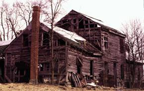 |
Figure 10. “Building out” as
the family expanded: Jeremiah Duncan homestead, central two-storey log pen with
log wing on right (c. 1790) expanded with frame ell on left, all covered with
sawn siding from Brutus’ mill (c. 1840). |
Brutus moved into a two-story saddle
bag log cabin his father had built in 1813 as an improvement and had leased to
tenants for the next 15 years. As his
family grew to include three children, he chose to build a new house
altogether, the elaborate transitional brick structure which is the striking
survival today. In doing so he was
clearly making a political statement of his wealth and position in the
community, but he was responding to the same need for additional domestic space
as his neighbors. His younger brother
put the problem to him in the form of advice which he offered as Brutus was
planning to build. (This brother,
Cassius M. Clay, was quite brash, and had no qualms about offering advice to
his elder, in fact to anyone who would listen to him).
“..........I think it advisable not to
build a partially neat house, but wait until you can go “whole hog”. Much money is generally expended in building
out houses, which, when the “great house”: is completed, are generally
consigned to the flames; unless you could, like the Yankees here (he was writing
from college in Connecticut) , put your
house in a wheel barrow and run off with it (CMC to BJC June 19, 1831).”
Despite this, Brutus pointedly saved
the earlier log cabin (as did Cassius when he came to build almost 30 years
later in Madison County), and lined up the new structure with the old, side by
side. Thereafter house servants lived in
the cabin. In this process of homestead
modification, all before 1845, the orientations of homesteads remained the same,
responding to several factors. Many
faced south to maximize warmth and light during the winter months even if they
could not, in so doing, avoid the heat of long summer days. There could be
variations: Kennedy’s stone house, the earliest home in the neighborhood, in
fact remained facing east looking over Kennedy’s Creek which at the time (circa
1785) probably served as the track
through the neighborhood, a fact that has escaped recent architectural historians
(Wooley 2008:110-111).
The Community Arrives
Two elements were added to this dispersed
neighborhood in the 1840s creating the built framework of a rural “community,”
a church and schools (note plural).
Moved by Jesse Kennedy’s encounter in 1845 with Universalism (Anon.1845)
(a religious group which ultimately would merge with Unitarianism in the 1960s)
the three neighbors, Kennedy, Brutus Clay, and Daniel Bedinger, sought bids for
a “Universalist Meeting House” which was built during the following year on
land donated by Kennedy, with funds from all three and lumber from Brutus’ saw
mill. The plan of this building, which
can be reconstructed from the bid specifications and apparently replaced
meetings in Kennedy’s stone house, indicates a fairly large though simple building
for what would appear to have been a relatively small congregation, set in a
double door structure with a simple classical pediment and gable end porch. It
was called the Concord Church after the name Jesse Kennedy had given his
father’s stone house which he had inherited. A probable explanation for its
size was that it was built to house not only the land owners but their slaves
as well. In fact the floor plan of the
church is an indication of an African American slave population which by then in
this community far out numbered the white.
Significantly, this church was the
first structure in the immediate community built to face the road. In addition it was politically a community feature which was built on the
road for common access in the way the houses of its parishioners had not. The second was a school house for white
children. In 1848 Brutus sawed lumber
for neighbor Henry Clay’s schoolhouse which, as a local resident who went there
remembers, was a “one room structure
taught by a red haired school marm, where the neighborhood children went to
elementary school” (C.M.Clay, Jr., written in one of his school books). Beyond the folk lore and the sawing bill,
this structure has disappeared although the curve in the road where it was
built remains, reduced by subsequent road grading.
This effort for the children of the
whites was apparently paralleled by a school for the children of the slaves that
has survived. Brutus’ neighbor, Daniel
Bedinger, was an avowed emancipationist.
He owned far fewer slaves than Brutus, in 1837 only seven while Brutus
had 38 at that time. One of these, a
woman, was educated, taught school, and for her efforts and abilities gained
her freedom and was repatriated to Liberia where she and her family suffered
intensely. Bedinger built his school
behind his house, probably one of two rooms in a detached kitchen dependency, where
it still survives (Figure 11). There is
some suggestion from Brutus’ sawmill records that the building was built in the
early 1840s.
 |
Figure 11, Daniel Bedinger homestead c 1820 with
dependency that reputedly served as school for African American children (photo
1999). |
The final element, equally important
although in quite another way, was the formalization of a road out of the
traditional lanes which linked dispersed homesteads. In 1848 the Paris-Winchester turnpike company
was formed financed with stocks and bonds held by the adjacent landowners, one
of several in the county. The
construction of a macadam roadway began shortly thereafter. This produced a superior road surface (not
substantially changed until 1941) which was a great improvement over the
existing trace. It also involved the construction of facilities, the tollhouses
every five miles (Figure 12), bridges over the watercourses, and fencing
paralleling the highway which was constructed by landowners, often in dry stone.
 |
Figure 12. Toll house of Paris-Winchester turnpike, 2
miles from |
In addition, a covered bridge was
built across Kennedy’s Creek (Figure 13) at the church and in front of the
farms of Brutus and his neighbors.
Although not a substantial structure, it made crossing a minor but difficult
water course subject to flooding all that easier.
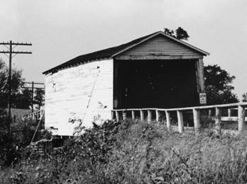 |
Figure 13. Covered bridge
over Kennedy’s Creek at |
While it is difficult to determine
the size and composition of the local population around Brutus’ farm, by the
decade of the 1850s it was probably far higher then it had ever been or ever
would be thereafter. Although the number of slaves varied tremendously between
neighbors, most owned several and it is certain that the black population far
outweighed the white. The lack of stores
in this community reflects the fact that, in many respects, the farms were
still self-sufficient. In addition,
Paris was only three miles away and purchases in the town rapidly replaced
homestead self sufficiency. Yet despite
even this, Brutus’ wife -- with the aid of her women slaves -- would continue
to spin and weave flax for the everyday cloths of slaves and her family until
the late 1840s. So also would her neighbors.
Life and Death of “Community”
What had developed here was a sense
of a local community. Anchoring it were
the dispersed farm homesteads of the vicinity.
They varied in size but, during the 1850s, for the most part were
enjoying financial prosperity. Added to
it were the school houses and the church, an expression of the stability which
this wealth had created. Even though
built on slavery, both included an ordered place for black and white. This, I venture to say, was part and parcel
the rural Whig ideal here in Central Kentucky.
This southern rural Whig “community,”
both the society and the structures, did not survive the Civil War. Like the Whig political world in general, it
was buried with the end of slavery although death had occurred earlier,
symbolically, with the death of Henry Clay in 1852. However, it is far too one-dimensional to
view the change as simply the result of the end of slavery for it was more
complex than that. As an indication of how conservative and backward-looking it
was, its roots lay in the political acts of land survey and alienation before
1800.
The major change came in population
numbers. During the war the slave population drifted away from the local farms,
enticed to join the Union Army, principally to free themselves from their
owners who were not yet subject to the Emancipation Proclamation (slavery would
not end in Kentucky until 1866). For example, 17 young African American men
left Brutus’ farm to join the Union Army in addition to three of his sons. Most
of the bondsmen did not return after the war as cash laborers. In the end the
freedman population would virtually disappear to the county seats like Paris,
three miles away. There they and their
descendants existed until the 1960s in segregated housing, gerrymandered out of
the town and into the county (still voting in the county precinct that included
Brutus’ farm), yet side by side with the white towns themselves. The nearest of
these, built in 1866 was, appropriately, called Claysville.
The white population also declined,
but for generational reasons. The
mid-century saw the maturing of the generations first born on these scattered
rural homesteads. In more than one case
declining farm size through inheritance and the lure of the still-open frontier
deprived the now elderly farm family of heirs and a process of land
consolidation began. Jesse Kennedy died
in 1866 leaving at least four heirs scattered west of Central Kentucky. Brutus bought them out one-by-one. Daniel Bedinger and his wife were
childless. With advancing age they sold
out to Brutus and moved to Lexington.
Jeremiah Duncan died in 1876, pre-deceased by his one son who had died
in 1847. Again Brutus bought his farm.
This
massive depopulation, which for this rural community probably saw the exodus of
over 200 individuals, may have moved people little more than three miles. However, it removed them from the rural community which had grown up before the
war. In the era of wage labor and tenant
farming which would develop replacing slave labor, quite a different domestic
organization of the country would develop.
In this particular community the wage laborers would come out from town
to work, and the tenants, as these developed with the tobacco industry in the
latter part of the century, would set up homesteads in widely dispersed simple
structures and houses abandoned by their former white owners. A significant
structural addition to the neighborhood, particularly after 1900, were the
dispersed, large, air cured tobacco barns.
The quaint Concord Universalist
congregation would also break up during the war and there would be an attempt
to convert the structure to a blacksmith’s shop which failed when it burned
(Perrin 1888:88). No such business was ever again attempted in the neighborhood
nor was a new church raised to serve the spiritual needs of this community, its
place taken by churches in the nearby towns.
In part this was also due to population shifts: with the slaves gone,
the white masters were left preaching to each other. In part the congregation foundered due to war
time strains. Quite literally one side
of the road became notably Confederate in its sympathies, while Brutus’ side
retained its Whiggish Unionist ties (he was a Unionist member of Congress from
1863 to 1865). Also the Universalist
denomination, which had been a highly
distinctive feature of this community in a world which was generally
evangelical, would be submerged in
the currents of evangelicalism.
Synthesis
The final stage in modernization, which
is most visible today, which clearly followed the above and neither anticipated
nor preceded them, was the modification of homes anywhere near the road to face
the road. Of these, Samuel Clay’s
Marchmont was the most extreme example.
Leaving his father’s brick “I” house buried in the farm, Samuel built
his imposing house on the road, producing the total effect so well recorded in
the Perrin (1882) birds-eye view. Less
extreme examples, because they involved modification of existing structures,
were the effects on other neighbors.
Also elaborate, although it involved
the modification of an existing structure rather than construction of a new
one, was the transformation of Richard Lindsay’s home (Langsam and Johnson
1985:184) across the road from Brutus.
Built initially as a log cabin early in the nineteenth century, the home
was transformed into a frame Federal structure by 1850 keeping pace, perhaps,
with Brutus’ home building and still facing north/south. Finally, in the latter part of the century
the orientation of the house was shifted to face west towards the road and
redone into an eclectic structure with Georgian and Greek Revival elements
(Figure 14). Tightly grouped around the
homestead were the farm structures.
 |
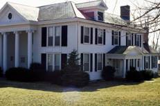 |
Figure 14. Richard Lindsey
homestead: A. contemporary frontal view from main road, B. side view showing
far right, surviving log wing (c. 1810), center, “Greek Revival” main block
facing north (note Greek influenced portico)(c. 1840), on left revivalist front
added in 1900 (photo 1999). |
| A. |
B. |
More typical was the adjoining
Bedford homestead (Figure 15). Beginning
as a log structure facing south, with the postwar period it was reoriented to
face the road and embellished with a large frame addition dwarfing the log
beginning.
 |
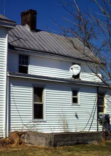 |
Figure 15.
|
| A | B. |
.
Even Brutus’ house did not escape a
degree of modernization. Always far
removed from the road, there was no attempt to change its orientation. But Brutus’ son’s third wife (two died in
childbirth) insisted in 1880 that one of the wings be replaced with a two-story
structure with bay windows, a bracketed roof, and a touch of fashionable
stained glass. This structure enclosed
stacked bathrooms, one for each floor and the first such fixtures in the
rambling old house, and a primitive central heating system. Apparently the changes were regarded with
deep foreboding by her new husband and her step children who would rather have
done nothing and who apparently preferred chamber pots, privies and coal fire
grates.
This final step in “modernization,”
creating what is essentially the landscape of today plus or minus a few
structures, can best be seen as a race to establish status in a new world, the
social vacuum created by the self-destruction of Whig society. In the wide-spread desire to face the road
and to make a statement with a neat, tidy, and comprehensible farmstead, if not
a highly elaborate home, this part of the country, indeed much of the old
south, was perhaps 20 to 25 years behind the rest of the country. The statements which were made in vernacular
architecture, whether in the rebuilt Whig homestead or the new “Queen Ann”
frame structure, or in the elaborate bracketed Italianate pile, were made from
an insecure vantage point. The late nineteenth
century for these local farmers was a period of uncertainty in which the values
of their fathers and grandfathers would be tested by a far more complicated
world than they had known, one created once and for all by the Civil War.
Acknowledgments
This paper is a spin-off of a study
of farm structures on the Brutus Clay farm financed by the Kentucky Heritage
Council and the University of Kentucky.
The support of both is appreciated.
Quoted letters are published here with the permission of the University of Kentucky library and the Filson
Club. I also appreciate the support and
insights in that study of Howard Gregory, my partner in the field.
References Cited
Allen, L. F.
1844 Farm Buildings, American Agriculturalist 1(4):115-121, New York.
1852 Rural
Architecture. C.M. Saxton, New York.
Anon.
1845 Rodgers’
Memoranda of the Experiences, Labors and Travels of a Universalist Preacher:
Written by himself. John A Gurley, Cincinnati.
Aron, S.
1992 Pioneers and Profiteers: Land Speculation
and the Homestead Ethic in Frontier Kentucky. Western Historical Quarterly XXIII(2):May:179-198.
Dorris, J. T.
1945 Early Kentucky History in Madison County Circuit
Court Record, and Colonel William Harris Caperton’s Account of Estill’s Defeat.
Register, Kentucky State Historical
Society. 43(145):321-341.
Hammon, N.
1980 Land Acquisition on the Kentucky Frontier. Register of the Kentucky Historical Society
72:297-231.
Hood, J. L.
1977 The Union and Slavery: Congressman Brutus J.
Clay of the Bluegrass. Register of the
Kentucky Historical Society 75(3):214-221.
Hubka, T. C.
1984 Big
House, Little House, Back House, Barn: The Connected Farm Buildings of New
England. University Press of New
England.
Langsam, W. and G. Johnson
1985 Historic
Architecture of Bourbon County, Kentucky. Historic Paris-Bourbon County,
Inc. in conjunction with The Kentucky Heritage Council.
McMurry, S.
1988 Families
and Farmhouses in 19th Century America. Oxford University Press.
Perrin, W. H. ed.
1882 History
of Bourbon, Scott, Harrison, and Nicholas Counties, Kentucky:With an Outline
Sketch of the Blue Grass Region, Chicago, O.L. Baskin and Co., Historical
Publishers.
Price, E.T.
1995 Dividing
the Land. The University of Chicago Geography
Research Paper No. 4. Riesenweber, J. and K. Hudson
1990 Kentucky’s
Bluegrass Region: Tours for the 11th Annual Meeting of the
Vernacular Architectural Forum. The Kentucky Heritage Council, Frankfort.
Turner, F.J.
1992 The Significance of the Frontier in American
History. In The Frontier in American
History (reprint) by F.J. Turner, University of Arizona Press.
Wooley, C. M.
2008 Early
Stone Houses of Kentucky. University of Kentucky Press, Lexington.
Editor’s note: This paper was accepted
after Tier II review (see Author’s Guidelines).