Kentucky’s
Small Triangular Subtypes: Old Theories and New Data
Andrew P. Bradbury, D. Randall Cooper, and Richard L. Herndon
Abstract
Attempts to seriate morphological differences in Fort Ancient triangular points in the Ohio Valley have led to the development of a typology that continues to be used by some researchers in the region. This typology is purported to have established a fine-grained time sequence for the Fort Ancient period based on variation in stylistic attributes associated with these triangular points. More recent studies have lead to several modifications to the typology and called into question the reliability of the subtypes as more specific time markers. This paper examines the development of the typology and its usefulness in Fort Ancient studies by incorporating new data from recently excavated archaeological contexts in the region.
Small
triangular points have been used in the Ohio Valley area as temporal markers of
Late Woodland and Late Prehistoric cultures. While the name Small Triangular
Cluster (e.g., Justice 1987) is often used for most of these point types (e.g.,
Hamilton, Madison, Fort Ancient), there is much variation in both size and
shape of these points. Capitalizing on this variation, Railey (1992) used a sample
of small triangular points from Fort Ancient sites in northeastern Kentucky in
an attempt to provide a finer temporal placement of Fort Ancient points. A
number of sites have been excavated within the Fort Ancient area since this
point typology was defined. More recent data has lead to several modifications
to Railey’s typology (e.g., Bradbury and Richmond 2004; Carmean 2010; Henderson
2008). The impetus for the current paper came from application of the Railey
typology to triangular points recovered from the Elk Fork site in eastern
Kentucky. Data from this site seemed to be at odds with previously defined
temporal placement of the various point types. In this paper we review the data
for small triangular points from Fort Ancient sites and examine these data in
light of more recent excavations.
Railey Typology and Modifications to the Typology
In his original study Railey (1992) examined a sample of 133
triangular points from sites in northeastern Kentucky (Figure 1). His analysis
indicated that several types had a more restricted temporal range within the
larger Fort Ancient period. Eight triangular types were defined. Of these eight
types, five (Types 2-6) were identified with a tighter temporal range. Type 2
points were found to date early in the Fort Ancient period (ca., A.D.
1000-1300). Type 3 dated in the middle portion of the Fort Ancient period (ca.,
A.D. 1200-1400). Types 4-6 dated to the late portion of the Fort Ancient (post
A.D. 1400) period. Type 4 was thought to possibly represent a resharpened form
of Type 5 or 6 and could only be dated to the late Fort Ancient. Type 5 points
were thought to date earlier than Type 6, reaching their height of popularity
ca. A.D. 1400. Type 6 became the dominant type after ca. A.D. 1500.
![]()
Figure
1. Location of sites mentioned in text.
Bradbury
and Richmond (2004) examined a sample of 56 of the points from Railey’s study
and suggested, based on statistical analyses, that the three late Fort Ancient
types (Types 4, 5, and 6) were morphologically similar and could not be
confidently sub-divided based on metric data. Bradbury and Richmond did not
test the temporal designations of these types and accepted Railey’s temporal
assignments. In short, they suggest that the five types should be collapsed
into Early (Railey’s Type 2), Middle (Railey’s Type 3), and Late (Railey’s
Types 4, 5, and 6) due to the overlap in the types. In addition, they concluded
that the Middle Fort Ancient (Railey’s Type 3, coarse serrated) is somewhat
separate from the other types due primarily to the presence of serrations.
Henderson
(2008, also see Pollack and Henderson 2000) suggests that, based on newer data,
Type 5 triangular points date from early Fort Ancient to late Fort Ancient and
Type 2 points date from the early to middle portion of Fort Ancient. In short,
she found that the Railey types have longer temporal ranges than first thought.
Based on
points from the Broaddus site, Carmean (2010) suggested several additional
amendments to the typology. She (Carmean 2010:229-230) argues that: Type 4
triangular points are resharpened versions of early Fort Ancient points; Type 5
triangular points date from early Fort Ancient to late Fort Ancient (following
Henderson 2008 and Pollack and Henderson 2000); Type 5 and Type 3 may be the
same general type, the main difference being the serrations on Type 3; and Type
2 triangular points date from early to middle Fort Ancient times. Further,
Carmean suggests that some of the differences in point morphology may relate to
geographic factors, specifically the distance from the Ohio River.
Based on
revisions by Henderson and Carmean, it would appear that: Type 6 is the only
type that can be confidently assigned to the late Fort Ancient; Types 2 and 5 appear
throughout the entire Fort Ancient sequence; and Type 3 is still seen at middle
Fort Ancient. As can be seen, the previous researchers interpret triangular
points and their temporal placement differently. What is obvious is that a
confusing array of interpretations has been presented over the last twenty
years with little consensus. What is also becoming clear is the possibility
that a triangular point typology is not grounded in any sort of Fort Ancient
behavioral pattern.
The Elk Fork Site
The Elk
Fork Site (15Mo140) is located in central Morgan County, Kentucky near the
confluence of the Elk Fork and Licking Rivers. A data recovery was conducted at
the site during the summer of 2003 in preparation for the proposed realignment
and bridge replacement of Route 7 over the waters of Elk Fork (Herndon 2005).
This area is characterized by highly dissected V-shaped valleys produced by the
down-cutting of the Licking River and its tributaries. For this reason, the
region in which the Elk Fork site is situated consists predominately of steep
hillsides divided by narrow ridgetops and valleys. Exposed bedrock consists of
various members of the Lower and Middle Pennsylvania System (McIntosh 2002).
The site itself is located on three terraces (T1 to T3) of the Elk Fork
floodplain. The floodplain where the site is situated is approximately 500 m
wide and generally consists of lateral accretion of alluvium derived from
weathered shale and sandstone from the surrounding bedrock.
Although
cultural material was identified on each of the three terraces, all of the late
Late Woodland/early Fort Ancient occupation was located on the T1 immediately
adjacent to the river. The investigated portion of the T1 encompassed about
1,300 sq m. Field methods consisted of the hand excavation of test unit blocks
located in high artifact areas of the late Late Woodland/early Fort Ancient
occupation. Mechanical stripping was used for those portions of the occupation
not investigated in the block excavations. All features identified during the
data recovery were hand excavated.
A total of
three excavation blocks (Blocks 1, 2, and 3) comprising approximately 173 sq m
were hand excavated within the late Late Woodland/early Fort Ancient occupation
(Figure 2). Excavation Block 3, which was placed in the south central portion
of the T1 and the smallest of the three blocks, did not result in much material
being recovered. Consequently, this block will not be further discussed here as
it did not have any data relevant to the present discussion. The results of
Excavation Block 1 and 2 are below. As noted above, mechanical stripping
occurred on the T1 where block excavations did not test. In total, 56 late Late
Woodland/early Fort Ancient features were identified during block excavations
and mechanical stripping.
Excavation
Block 1 was located in the southeast corner of the T1 in an area exhibiting a
high density of lithic debitage in association with small triangular hafted
bifaces and a small amount of sandstone tempered, cordmarked pottery. Within
this block, the Ap horizon extended from ground surface to approximately 25 to
30 cm bgs (below ground surface). From the bottom of the Ap horizon to about 60
or 70 cm bgs was the B Horizon, which contained the late Late Woodland/early
Fort Ancient component. As can be seen in Tables 1 and 2, all the hafted
bifaces, most of the lithic debitage and pottery originated from the first two
levels (20 cm) of the B Horizon. The bifaces included Railey’s Types 2, 3, 4,
5, and 6 (Cooper 2005). Two small pit hearths were also located within this
horizon. The Bt1 below the B Horizon was generally devoid of artifacts.

Figure 2. Schematic overview of the late Late
Woodland/early Fort Ancient excavations.
Table 1. Tabulation of lithic material in Block 1 by level
within the B Horizon.
|
Block
1 |
Biface |
Cobble
Tool |
Core |
Flake
Tool |
Ground
Stone |
Unmodified |
>1/4"
Flakes |
<1/4"
Flakes |
Total |
|
Level 1 |
12 |
0 |
6 |
1 |
0 |
0 |
540 |
563 |
1122 |
|
Level 2 |
4 |
0 |
0 |
0 |
0 |
0 |
146 |
245 |
395 |
|
Level 3 |
0 |
0 |
0 |
0 |
0 |
0 |
67 |
120 |
187 |
|
Level 4 |
0 |
0 |
1 |
0 |
0 |
0 |
40 |
59 |
100 |
|
Total |
16 |
0 |
7 |
1 |
0 |
0 |
793 |
987 |
1804 |
Table 2. Tabulation of ceramic material in Block 1 by level
within the B Horizon.
|
Block 1 |
Body |
Rim |
Sherdlet |
Burned
Clay |
Base |
Total |
|
Level 1 |
0 |
0 |
23 |
24 |
0 |
47 |
|
Level 2 |
0 |
0 |
4 |
2 |
0 |
6 |
|
Level 3 |
0 |
0 |
12 |
0 |
0 |
12 |
|
Level 4 |
0 |
1 |
8 |
0 |
0 |
9 |
|
Total |
0 |
1 |
47 |
26 |
0 |
88 |
Excavation Block
2 was located in the north central portion of the T1 in an area that had a high
density of lithic debitage and sandstone or limestone tempered, cordmarked
pottery. This area also registered numerous magnetic highs resulting from a
pre-excavation geophysical survey that was conducted at the site. This block
was by far the largest of the three blocks to be excavated consisting of
approximately 120 units. From ground surface to about 25 cm bgs was the Ap
Horizon. The late Late Woodland/early Fort Ancient occupation was restricted to
the underlying B Horizon which extended from 25 cm bgs to 75 cm bgs. As shown
in Tables 3 and 4, the vast majority of the lithic debitage and ceramic
material was located within the first three levels (30 cm) of the B Horizon,
including almost all the bifaces. These bifaces included all of the small
triangular types identified by Railey, except Type 7 (Cooper 2005). Also
located within this horizon were 16 features (mostly pit hearths but also two
storage pits, a shallow basin, and a processing pit) and approximately 30 post
holes associated with Structure 1. This structure was about 10 sq m in area and
consisted of single set posts with no associated basin or internal features.
Little else could be inferred about the structure as it was located near the
plow zone transition and as such was heavily impacted by plowing. The
underlying Bt1 Horizon was largely devoid of cultural material.
Table 3. Tabulation of lithic material in Block 2 by level
within Block 2.
|
Block
2 |
Biface |
Cobble
Tool |
Core |
Flake
Tool |
Ground
Stone |
Unmodified |
>1/4"
Flakes |
<1/4"
Flakes |
Total |
|
Level 1 |
63 |
0 |
6 |
1 |
0 |
1 |
1032 |
741 |
1844 |
|
Level 2 |
119 |
2 |
13 |
0 |
2 |
1 |
2389 |
1712 |
4238 |
|
Level 3 |
46 |
0 |
3 |
2 |
1 |
0 |
1169 |
992 |
2213 |
|
Level 4 |
10 |
1 |
1 |
0 |
1 |
1 |
256 |
196 |
466 |
|
Level 5 |
0 |
0 |
0 |
0 |
0 |
0 |
11 |
0 |
11 |
|
Total |
238 |
3 |
23 |
3 |
4 |
3 |
4857 |
3641 |
8772 |
Table 4. Tabulation of ceramic material in Block 2 by level
within Block 2.
|
Block
2 |
Body |
Rim |
Sherdlet |
Burned
Clay |
Base |
Total |
|
Level 1 |
99 |
0 |
736 |
54 |
1 |
890 |
|
Level 2 |
239 |
4 |
1865 |
207 |
2 |
2317 |
|
Level 3 |
133 |
6 |
1047 |
89 |
2 |
1277 |
|
Level 4 |
7 |
0 |
132 |
3 |
0 |
142 |
|
Level 5 |
1 |
0 |
9 |
2 |
0 |
12 |
|
Total |
479 |
10 |
3789 |
355 |
5 |
4638 |
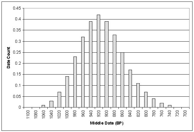
A firm dating
of the late Late Woodland /early Fort Ancient component was especially
important due to the vagueness of Late Woodland and early Fort Ancient systematics
in northeastern Kentucky. The radiocarbon dates from this component produced a
relatively tight cluster (Feature 12, 18, and 60a). Feature 12 was located in
the south central portion of the T1 and was identified during mechanical
stripping. Feature 18 was located along the southern edge of Block 2. Feature
60a was located just east of Block 2 and it was identified during mechanical
stripping. The raw BP ages fall within a 50 year span and the calibrated
intercepts fall within a 130, 80, or 40 year span depending on which intercepts
are used. Actual
intercepts are A.D. 1050 (1100) 1140 for Feature 12, A.D. 1180 for Feature 18,
and A.D. 1050 (1100) 1140 for Feature 60a (Table 5). The two sigma ranges for
all three features overlap each other, indicating in all likelihood a single
occupation episode (Figure 3). This hypothesis was tested using a T-test.
Results indicate that there is no significant difference between the dates (t =
.64; p < .05) and that they are contemporaneous. A single occupation is also
suggested by the excavation data in that the vast majority of the late Late
Woodland/early Fort Ancient material in Blocks 1 and 2 was confined to a narrow
vertical lense approximately 20 to 30 cm in thickness. Also, very few
superimposed features were found further suggesting the occupation was likely
small, of short duration, and of a single occurrence.
Table 5. Summary of Elk Fork late Late Woodland/early Fort
Ancient radiocarbon dates.
|
Lab No.* |
Provenience |
Measured Radiocarbon Age |
C13/C12 Ratio |
Conventional Radiocarbon
Age |
Calib. Range 2 sigma |
Calibrated Intercept |
Calib. Range 1 sigma |
|
Beta-192110 |
Feature 12 |
930±50 BP |
-25.0 0/00 |
930±50 BP |
AD 1010 to 1220 |
AD 1050(1100)1140 |
AD 1030 to 1180 |
|
Beta-192111 |
Feature 18 |
880±60 BP |
-25.0 0/00 |
880±60 BP |
AD 1020 to 1270 |
AD 1180 |
AD 1040 to 1230 |
|
Beta-192113 |
Feature 60A |
930±50 BP |
-25.0 0/00 |
930±50 BP |
AD 1010 to 1220 |
AD 1050(1100)1140 |
AD 1030 to 1180 |
|
|
Figure 3. Late Late Woodland/early Fort Ancient radiocarbon dates from Elk Fork. |
The
radiocarbon data, lack of maize, and ceramic data all indicate a single Late
Woodland to early Fort Ancient component. This horizon was sandwiched between
two sterile layers and represented the only Fort Ancient component at the site.
Given its temporal placement, if the Railey typology is correct, then we should
only see Late Woodland and early Fort Ancient types in the assemblage. With
modifications by Henderson and Carmean, we might also expect some Type 5 points
in addition. However, the 90 points recovered from this site included all of
the subtypes which were previously thought to mark different time frames within
the Fort Ancient period (Figures 4 and 5). Type 2: flared base small
triangular, which should be the dominant type according to the Railey typology,
represents less than 25 percent of the points (n = 21, 23.3%). In addition,
some of the classic types (e.g. Levanna and Hamilton) common for Late Woodland
sites were also recovered (n = 10, 11.1 %). We should also point out that there
were 2 Jacks Reef corner notched and 2 Jacks Reef Pentagonal points, not
included here. The unknowns here include some points that could be placed in
more than one type.
The C14 module
in Kintigh’s (2006) “Tools for Quantitative Archaeology” program was used to
provide a graphical analysis of the radiocarbon dates. The uncorrected dates
were used for this analysis. The assumption is that for any time interval, the
probability that the true date of a sample is within the interval can be
calculated from a normal distribution. Each date from a site, or specific
context, is treated as a normally distributed probability with a mean and
standard deviation given by the lab (Kintigh 2006:102). In examining multiple
dates, for each interval the probabilities for the dates are summed. For each
interval, an expected number of dates can be determined for that time period.
These can then be used to graphically show the dates obtained from a site. If a
single occupation is indicated, a unimodal graph will result. A distinctly
multimodal graph may indicate multiple occupations. Output from the C14 module
was imported into Excel for graphing purposes. Analysis of the dates for Elk
Fork indicate a single occupation (Figure 6).
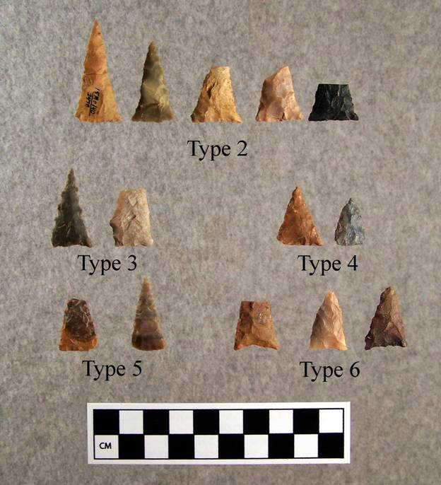 |
Figure 4. Type 2-6 Fort Ancient
triangular points from Elk Fork. |
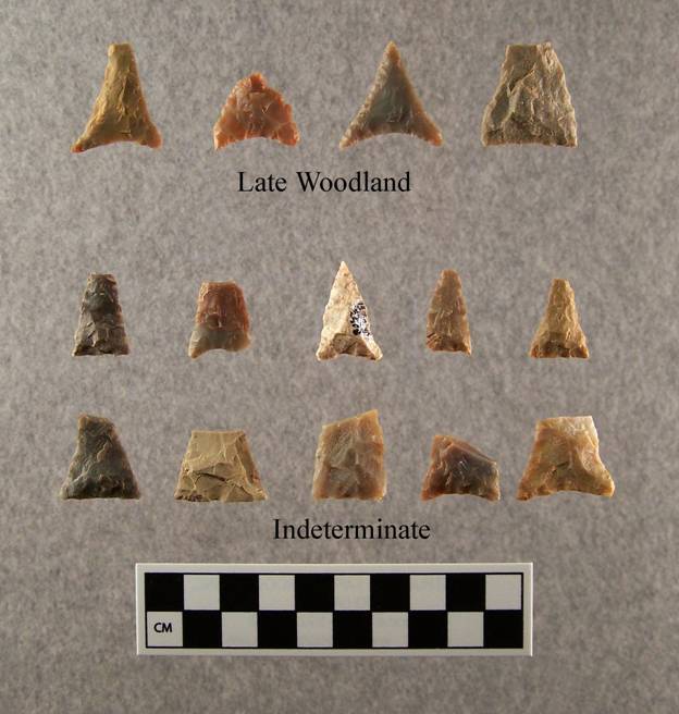 |
Figure 5. Late Woodland triangular types (top row) and
various indeterminate triangular points (bottom two rows) from Elk Fork. The
indeterminate triangular points either matched multiple Railey types, or no
type. |
 |
|
Of
note is that one of the main concentrations of debris encountered at Elk Fork
was associated with an alignment of post molds designated Structure 1. Twelve
triangular points were found inside this structure. Types recovered from the
house were two Type 1’s, a Type 2, and a Type 6. The Type 6 was recovered from
the level below a Type 2. There was also a Levanna, and an apparently
unfinished point. Six small triangular points from the house could not be more
specifically typed. Elsewhere on the site, in at least 5 cases, points of
supposed later type were found in the same level of the same excavation unit as
points of earlier type.
Given the
types of triangular points recovered, without the tight stratigraphic controls
that were possible at Elk Fork, it would be natural to conclude that the points
represent a long series of occupations spanning the Late Woodland and Fort Ancient
periods. And in fact, that was the conclusion of the phase II report (Martin
2002). However, on closer examination, this conclusion, based in part on the
form of the small triangular points, was erroneous.
Reexamining the Original Data Set
As
Railey
(1992:168) summarized his study by stating the "[a]nalysis of the chipped
stone artifacts focused on the identification of patterns that might contribute
to the development of a Fort Ancient chronology for northeastern Kentucky. With
the basics of the triangular projectile point sequence established for the
study area, it should now be possible to identify the temporal placement of
components lacking diagnostic ceramics, such as small hunting camps (e.g.,
Seeman and Munson 1980) or sites identified through surface
reconnaissance." More recent assessments have suggested that Railey’s
study relied on characterizing site assemblages, not dating a site’s component
based on a single point style (Henderson 2008:742). Here we examine the
original study, the context of the points used in that study, and further
examinations with more recently recovered data.
One hundred
thirty-three points recovered from five sites comprised the original sample. Of
these points, 78 were from unmixed contexts. Examining the original data on
which the triangular point study was based indicates some discrepancies between
point types and periods of occupation (Figure 7). For example, there are a
number of Type 2 points at Snag Creek and Thompson Upper, both of which are
suggested to be late Fort Ancient. The upper component at Thompson (late Fort
Ancient) has more “early” points than “late” points. Half of the points at Fox
Farm (lower) are late, rather than middle.
What the
data do suggest is that there may be a “general trend” of certain types through
time, but they are not diagnostic of a tighter temporal range. Sample sizes for
some sites are also somewhat small and questionable. Laughlin is the only site
that has all the “right” points associated with it (all are late Fort Ancient
as is the site), but the sample size (n = 9) is low. Note that only 2 were from
unit contexts, the rest are from surface context. It should also be noted that
the sampling at these sites consisted of surface collection and the excavation
of 3 to 6 units (Table 6) and features identified within these units. While the
sites were suggested to represent, for example, early Fort Ancient, middle Fort
Ancient, or late Fort Ancient, an examination of the radiocarbon dates for
these sites suggests that multiple occupations are indicated for all of the sites.
Radiocarbon dates from the reports were examined as was conducted above for Elk
Fork. In many cases, multiple occupations are indicated. For example, three
occupations are suggested for Thompson (Figure 8), two for Fox Farm (Figure 9),
two for Snag Creek (Figure 10), and two for Augusta (Figure 11). Some of these
components were noted by the original researchers. However, in no case were any
of the sites demonstrated to represent single occupations. In addition, the
mixing of several components was noted on some sites. In short, while the
Railey study represents an interesting first step into the variation in Fort
Ancient points, the original data were recovered from somewhat questionable
contexts and do not support the interpretations of the original study. When the
point typology is applied to sites with sealed deposits, short temporal spans,
and large point assemblages, the initial finds of the study can be called into
question.
Figure 7. Point types by sites
for the original Railey (1992) study. Figure 8. Graphical
representation of radiocarbon dates for Thompson. Figure 9. Graphical
representation of radiocarbon dates for Fox Farm. Figure 10. Graphical
representation of radiocarbon dates for Snag Creek. Figure 11. Graphical representation
of radiocarbon dates for Augusta.
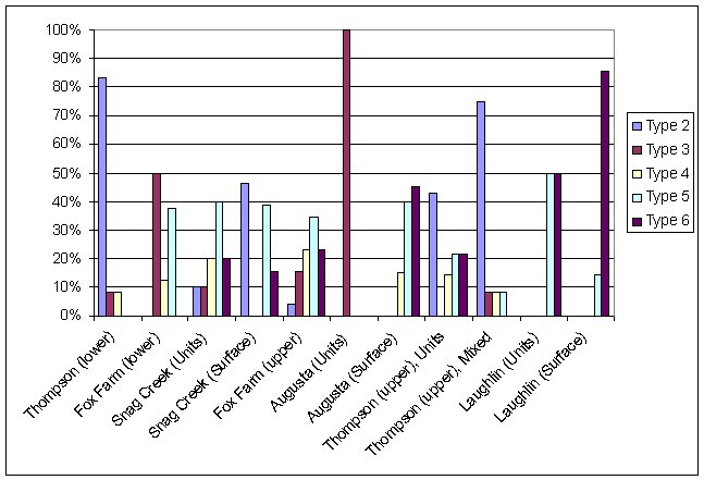
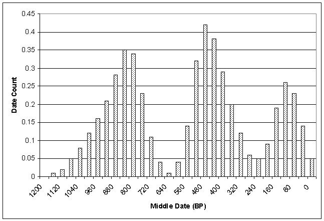
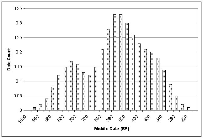
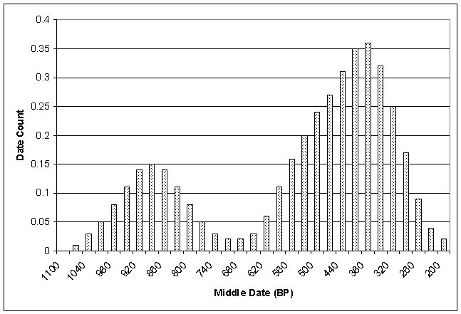

Table 6. Data on Excavations
(Compiled from Henderson 1992).
|
Site |
Excavations |
Dates
BP |
Components |
Temporal |
|
Thompson |
Surface
Collection, 4 2-x-2m units, and 4
features |
110+/-60; 490 +/-50; 400 +/-70; 810 +/-60 ; 920
+/-100 |
Two,
possibly three |
Early
and Late Fort Ancient |
|
Fox
Farm |
4
1-x-2 m units and 4
features |
390+/-70; 530 +/-70 ; 790 +/-70 ; 590 +/- 60 |
Two,
upper and lower |
Middle
and Late Fort Ancient |
|
Snag
Creek |
1
1.5-x-2.5 m unit and 5
1-x-2 m units, and 5 features |
360+/-70 ; 390+/-70 ; 520+/-70 ; 890+/-80 |
|
Late
Fort Ancient |
|
Laughlin |
surface
collection, shovel tests, 1 1-x-1 m unit, 3 1-x-2 m units and 1 feature |
|
One |
Late
Fort Ancient |
|
Augusta |
3
1-x-2 m units and 6 features |
470
+/-90 ; 210 +/-60 ; 470+/-70 |
One |
Late
Fort Ancient |
Since
the original study, much work has been conducted in Fort Ancient sites in Kentucky
owing much to the efforts of Pollack and Henderson and their colleagues.
Examining triangular types reported for various sites within the Central and
Eastern Bluegrass indicates variation in the percentages of the triangular
types (Figures 12 and 13). Similarly, when Middle Fort Ancient and Late Fort
Ancient sites are examined there are no consistent patterns in the percentages
of the types represented in the respective time periods (Figures 14 and 15).
Types 2 and 5 are common on the Middle Fort Ancient sites and often out number
the Type 3 points, contra the original study. Likewise for the Late Fort
Ancient sites, Type 2 points appear in large numbers on some sites. For
example, at Thompson, Type 2 points predominate and at Snag Creek Type 2 points
are the second most common type represented. The data indicate that there is
much variation in the point types recovered from, for example, middle Fort
Ancient sites, and there is no consistent pattern to this variation across
space. The typology fails no matter if one tries to use individual points or
tries to characterize an assemblage to determine temporal placement. What we do
note is that: Type 6 points appear most commonly on late Fort Ancient sites and
Type 3 are most common on middle Fort Ancient sites. However, these types
appear on sites from other temporal periods too, and there is no consistent
pattern.
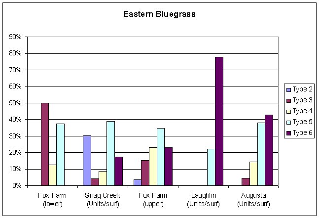 |
Figure 12. Railey
types for Eastern Bluegrass sites. |
 |
Figure 13. Railey
types for Central Bluegrass sites. |
 |
Figure 14. Railey
types for Middle Fort Ancient sites. |
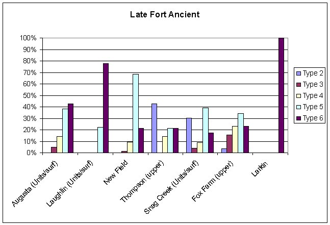 |
Figure 15. Railey
types for Late Fort Ancient sites. |
With
respect to early Fort Ancient, the Type 2: Flared base triangular was the most
common subtype at Elk Fork, but only 21 of the 90 small triangular points fit exclusively
within this type. This contrasts somewhat with the lower component at Thompson,
where 10 (83%) of the triangular points were Type 2. Lower Thompson also
included a Type 3 and a Type 4. Small triangular points at the contemporaneous
Muir site in Jessamine County were described as being on a continuum, with some
points being straight sided with concave bases, but most points having straight
to convex bases and lateral basal projections (Turnbow and Sharp 1988). The
latter fit the definition of Railey’s Type 2, flared base triangulars. At the
Dry Run site, described as a transitional Late Woodland/Early Fort Ancient site
in Scott County, only two of the 38 small triangular points recovered fit
within Type 2. Most (n = 23) were described as “Straight Base Triangular”
(Sharp 1984). These correspond most closely to Railey’s Type 5 (Herndon 2005).
While the original definition of Type 3
points was based on the presence of coarse serrations, Henderson (2008) has
defined a Type 3.1. These are finely serrated points. She suggests that Type
3.1 are early Fort Ancient. Finely serrated triangles have also been recovered
from a late Fort Ancient context at the Burning Springs Branch site near
Marmet, West Virginia (Bradbury 2008: 762). Also of note is that Henderson
(2008) suggests that Type 2 and 3 represent the same general form with the
coarse serrations of the Type 3 creating the difference. Conversely, Carmean
(2010) considers Types 3 and 5 as representing the same general form.
To further
examine the relationship between Types 2, 3, and 5, we pulled the metric data
collected by Bradbury and Richmond. A discriminant function analysis was
conducted to determine if the three types (2, 3, and 5) could be separated
based on metric attributes (Figure 16). Blade shape (blade shape = metrically
measured incurvate, excurvate, straight) and edge angle were determined to be
the best variables to separate the three groups. A 70.8 percent correct
classification rate was achieved. Of note, no Type 2 points are classified as
Type 5 and vice versa. Misclassifications were: Type 2 points being classified
as Type 3; Type 3 being classified as either Type 2 or Type 5; and Type 5 being
classified as Type 3. Henderson suggested that Type 3 was a serrated version of
Type 2 while Carmean suggested that Type 3 was a serrated version of Type 5.
The data presented here suggest that they are both right. The discriminant
function analysis indicated that edge (blade shape) and (blade) angle were the
best variables for separating the three types. ANOVA results indicated that
these two variables, along with lower width and thickness, were the only
variables that were significantly different across the types. No real pattern
was seen in the lower width and thickness data. However, the edge and angle
data do show an interesting pattern. As edge shape increases so does angle. In
addition, there is a general trend from Type 2 to Type 5, with Type 3
overlapping the other two types.
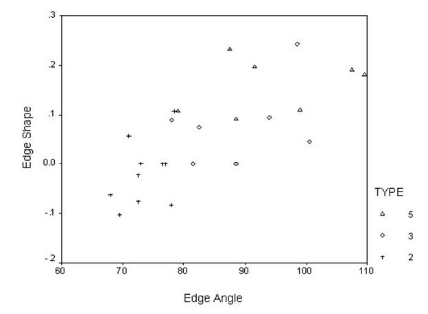 |
Figure 16. Discriminant Function
Plot. |
Discussion
Examining all of the point data, it would
appear that there are some basic trends in Fort Ancient triangular point
morphology. Basically, Type 2 points occur more often early and Type 6 points
occur more often late. However, in no case do you have only one type of point
present. In many cases, points are mostly of one or two types, but the other
types can also be present. Further, there does not appear to be any consistency
in the types that appear together. Again these data indicate that if you have a
large assemblage, the dominant type present will give you a ball park estimate
of the age. If you have a small sample size, it is best not to use points to do
anything more than say it is Fort Ancient. In addition, Bradbury and Richmond
(2004) suggest that based on morphology, the Type 2 and Types 4/5/6 are most
similar. Likewise, Type 3 points are similar to both Type 2 and Type 5 if the
serrations are not considered. These data suggest that variation in point
metrics forms a continuum from early to late in the Fort Ancient sequence.
Rather than distinct types being present in each of the sub-periods of Fort
Ancient, there is gradual change over time in point size/shape.
Many factors may influence point
morphology. For example, there are likely idiosyncratic differences between
different knappers, or different cultural groups. In addition, some knappers
are simply more skilled than others. Bob Dawe (1997) has described similar
mixed results in efforts to develop arrow point typologies in the northern
plains region. In a study of points from the Head-Smashed-In bison kill site in
southern Alberta, Canada, he noted much greater consistency in size and greater
skill in craftsmanship for points from the actual kill site than for points
from the adjacent camp and meat processing area. He suggested that the more
eradically made points were tips for toy arrows. Whereas the points from the
kill site could be attributed to the actual hunters, the processing area would
have been occupied by entire family groups, including children, who would
probably be reenacting the hunt they had just witnessed.
Even the
range of variation for points made by a single knapper is not clear. Timothy
Wright (2004) recently described 43 triangular points found together in a Late
Woodland burial at the Secrest – Reasoner site in east-central Indiana. Several
lines of evidence were presented which suggest the points were made by a single
knapper, possibly the individual they were buried with. The strategy of
reduction was similar and the same raw material was used for nearly all of the
points. Some points even appeared to have been produced from the same core. But
there was obvious variation in their size and shape. His illustration shows
some specimens with straight basal margins and some with incurvate bases. Some
have incurvate sides and some have straight sides. This is also seen
historically with Wiessner’s (1983) study on !Kung arrow points.
Other
factors that may have an influence on point morphology include the species of
prey hunted, the method of hafting the point, resharpening of points, or even
modifications to the point to facilitate hafting in a previously manufactured
haft. All of these factors would create variation in point morphology and none
are specifically temporal.
In the
central Illinois Valley, Shott (2003) noted temporal trends in triangular point
form. He concluded that changes were complex and continuous, and could not be
viewed as a succession of discrete types. The same might be true of the Fort
Ancient area of Kentucky. At Elk Fork we can clearly see a trend towards larger
and more widely based points around 1100 AD, but the overall range in small
triangular point form from this discrete component suggests that subtypes of
small triangular points, as currently defined, cannot be used to accurately
determine relative age. The traditional “index fossil” approach used to
determine the ages of hafted bifaces from earlier periods cannot be applied
with equal confidence to subtypes of small triangular points within the narrow
timeframe of Fort Ancient.
Point Classification: A Proposed Solution
Part of the
problem with the current typology is the lack of mutually-exclusive types
(Table 7). For example: Type 2 points have a convex OR straight base and an
incurvate blade; Type 6 has an incurvate base and excurvate OR straight blade.
Two different researchers could type points from the same site and come up with
different types. In essence, this problem defeats the purpose of a typology,
and for all practical purposes, invalidates any results that may be produced
through its use.
Table 7. Railey (1992) Type
Descriptions.
|
Type |
Base |
Blade |
Serrations |
|
2 |
Excurvate
or straight |
Incurvate |
None |
|
3 |
Straight
or excurvate |
straight |
Coarse |
|
4 |
Excurvate,
straight or incurvate (rare) |
Excurvate |
None |
|
5 |
Straight |
Straight |
None |
|
6 |
Incurvate |
Excurvate
or straight |
None |
Based on
the above problems that have been observed with the Fort Ancient point typology,
we recommend the abandonment of the typology. While we see the typology as a
good start in examining the variation in Fort Ancient triangular points,
additional data amassed since the original study has indicated a number of
inconsistencies. In order to determine what is changing, and why, we need to be
able to graph the changes, and the direction of change, of specific attributes.
This needs to be done over large geographic areas to determine if there is
geographic variation in point morphology too.
Part of the
solution is the use of a paradigmatic classification system (sensu Dunnell
1971). We provide a possible example here (Table 8). Three attribute dimensions
are used with various attribute states under each dimension. For the Fort
Ancient points, we suggest four attribute dimensions: base shape, blade shape,
serrations, and basal flaring. Attribute states under both base and blade shape
would be: convex, straight, and concave. These shapes are defined by laying a
straight edge along the point base or blade. Attribute states under serrations
would be: not present, fine serrations, coarse serrations. Basal flaring could
be used as a presence/absence variable. The intersection of these attribute
dimensions creates the classes. For example; convex base-straight blade-no
serrations-flared base; convex base-concave blade-fine serrations-non flared
base, etc.
Table 8. Suggested
Classification System
|
Attribute |
Dimension |
||
|
Base |
Incurvate |
Excurvate |
Straight |
|
Blade |
Incurvate |
Excurvate |
Straight |
|
Serrations |
None |
Coarse |
Fine |
|
Basal
Flaring |
Absent |
Present |
|
In using
this classification, we can then map the classes over time and space. In
addition, as each of the classes are well defined and mutually exclusive, analyst
bias should be at a minimum. One can then examine temporal changes in each of
the attributes (base, blade, serration) and the intersection of these
attributes over time. In addition, data will need to be recovered from sealed
sites, with short time frames indicated, and well dated contexts.
Alternatively, metrics can be used to define concave vs. convex and these
differences mapped both spatially and temporally. Once such data are collected
from secure, well-dated contexts, the serriation might be attempted using
either attributes or classes (e.g., Duff 1996.).
For
example, plotting the base shape by edge shape using metric data produces the
plot in Figure 17. What these data show is that there is continuous variation
in point base and blade shape. There is no indication of attribute clusters
that would indicate the presence of discrete point types. We infer that there
is a possible temporal component to the data based on previous data suggesting
that flared bases are more common early in the Fort Ancient sequence while
excurvate blades are more common late in the sequence. Finer temporal
resolution, if it exists, cannot be derived from the Railey typology due to
problems as noted above. We also note that the data used here was based on the
original Railey (1992) data set, thus we cannot examine potential geographic
influences within the point sequence as they are all from the same general
region. Other data that we presented above suggest that geographic differences
in points exist, so the temporal component suggested here may be geographically
specific.
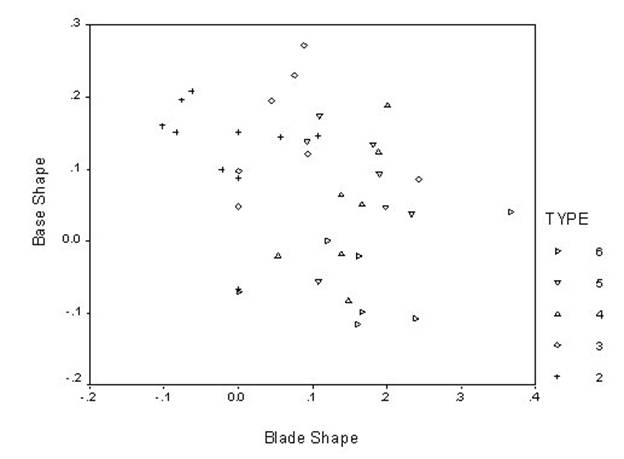 |
Figure 17. Base shape by blade
shape. |
At a
general level, it might be possible to derive very basic information from point
types; however, such information cannot be used in and of itself to provide
temporal information for a site without the presence of other temporal
indicators (e.g., ceramics, radiocarbon dating) or without large samples of
points. The use of the typology is masking much of the variation in point
morphology so that finer resolution of potential spatial and temporal
relationships of various attributes cannot be examined. To further test the
hypotheses suggested here based on a sample of points, a larger dataset needs
to be amassed. These data will need to be from contexts with tight temporal
control. In addition, metric data is needed to provide fine-grained resolution
to point variation. The use of point types for addressing such questions is
wholly inadequate and should be abandoned.
Summary/Conclusions
While
Railey’s typology was innovative for its time, we must conclude that it is way
past time for the typology to be abandoned. We see the original typology as a
good starting point, but subsequent data has indicated that the temporal
sequence that was originally proposed is not accurate, either for temporal
placement of single points or for characterizing an assemblage of points. The
use of the current point typology stifles our understanding of triangular point
variation, and it provides false data that masks many other aspects of Fort
Ancient lifeways.
Concerning
the variation in points, we agree with Henderson (2008:858) that an important
question is, why the variation in Fort Ancient points? We recognize that some of
this variation may have a temporal component to it, but we should also ask,
what other factors influence this variation and are these factors similar
across all of the Fort Ancient area? New methods must be sought out, examined
and re-examined, using data derived from secure, well dated, contexts with
short temporal spans. In addition, any new classification system must be based
on replicable measurements or discrete attributes, and it may not be possible
to use data from sites in one part of the Fort Ancient area to establish a
sequence for all Fort Ancient sites. The implementation of a new classification
system is imperative before we can fully understand the variation in triangular
point morphology and the forces that are driving these changes.
Acknowledgements
This paper was originally presented at the 67th Annual
Southeastern Archaeological Conference meeting in a symposium titled: Pots,
Political Complexity, and Remote Sensing: Papers in honor of R. Berle Clay’s
Contributions to Southeastern Archaeology. The authors would like to thank
Berle for the many informative discussions we have had with him over the years.
We also want to thank Brian DelCastello for taking the artifact photographs.
References Cited
2008
Lithic Materials. In Late
Prehistoric, Late Woodland, and Late Archaic/Early Woodland Transitional
Occupations at the Burning Spring Branch Site on the Kanawha River, West
Virginia, by Stevan C. Pullins, C. Michael Anslinger, Andrew P. Bradbury,
2004
A Preliminary Examination of Quantitative Methods for Classifying Small
Triangular Points from Late Prehistoric Sites: A Case Study from the Ohio River
Valley. Midcontinental Journal of
Archaeology 29(1):43-61.
2010
Points in Time: Assessing A Fort Ancient Triangular Projectile Point
Typology. Southeastern Archaeology
28(2):220-232.
2005
Chapter 7. Technological Analysis of the Lithic Assemblage, In Phase III Investigations at the Elk Fork
Site (15Mo140), Morgan County, Kentucky, by Richard L. Herndon. Contract
Publication No. 03-217. Cultural Resource Analysts, Inc., Lexington.
1997
Tiny Arrowheads: Toys in the Toolkit. Plains Anthropologist
42:303-318.
1996
Ceramic Micro-Seriation: Types or Attributes? American Antiquity
61(1):89-101.
1971 Systematics in Prehistory. The Free Press, New York.
2008
Chapter 7: Fort Ancient Period. In The
Archaeology of Kentucky: An Update, Volume Two. Edited by David Pollack, pp.
739-902 Kentucky Heritage Council State Historic Preservation Comprehensive
Plan Report No. 3.
1992
Fort Ancient Cultural Dynamics in
the Middle Ohio Valley. Monographs in World Prehistory No. 8. Prehistory
Press, Madison, Wisconsin.
2005 Phase III Investigations at the Elk Fork Site (15Mo140), Morgan County, Kentucky. Contract Publication No. 03-217. Cultural Resource Analysts, Inc., Lexington.
Justice, Noel D.
1987
Stone Age Spear and Arrow Point of
the Midcontinental and Eastern United States. Indiana University Press,
Bloomington.
Kintigh,
Keith W.
2006
Tools for Quantitative Archaeology.
Computer package and supporting documentation.
2002
An Archaeological Survey of the
Proposed KY 7 Realignment and Bridge Replacement Upgrade (Item No. 10-291.00)
and a Phase II National Register Evaluation of 15Mo140 (Elk Fork Site) in
Morgan County, Kentucky. Contract Publication No. 02-203. Cultural Resource
Analysts, Inc., Lexington.
2002 Soil Survey of Magoffin and Morgan Counties, Kentucky. Natural Resource Conservation Service, United States Department of Agriculture.
2000
Insights into Fort Ancient Culture Change: A View from South of the Ohio
River. In Cultures before Contact: The
Late Prehistory of Ohio and Surrounding Regions, edited by Robert A.
Genheimer, pp. 194-227. Ohio Archaeological Council, Columbus.
1992
Chipped Stone Artifacts. In Fort Ancient Cultural Dynamics in the Middle
Ohio Valley, edited by A. Gwynn Henderson, pp. 137-170. Prehistory Press,
Monographs in World Archaeology No. 8.
1980
Determining the Cultural Affiliation of Terminal Late
Woodland-Mississippian Hunting Stations: A Lower Ohio Example. North American Archaeologist 2(1):53-65.
2003
Time as Sequence, Type as Ideal: Whole-Object Measurement of Biface Size
and Form in Midwestern North America. In Multiple Approaches to the Study of
Biface Technologies, edited by Marie Soressi and Harold L. Dibble.
University of Pennsylvania Museum of Archaeology and Anthropology.
1984
The Dry Run Site: An Early Fort Ancient Site in the Bluegrass. In Late
Prehistoric Research in Kentucky. Edited by David Pollack, Charles Hockensmith
and Thomas Sanders. The Kentucky Heritage Council. Frankfort, Kentucky.
1988
Muir: An Early Fort Ancient Site
in the Inner Bluegrass. University of Kentucky Program for Cultural
Resource Assessment, Archaeological Report 165.
1983
Style and Social Information in Kalahari San Projectile Points. American
Antiquity 48(2):253-276.
2003
Madison Triangles: There Must Be a Point. In Facing the Final Millennium: Studies in the Late Prehistory of Indiana,
A.D. 700 to 1700. edited by Brian G. Redmond and James R. Jones. Indiana
Department of Natural Resources, Division of Historic Preservation and
Archaeology. Indianapolis.
Editor’s note: This paper was accepted
after Tier II review (see Author’s Guidelines).