|
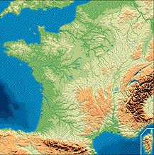
France has a surface area of 550,000 km2,
which makes it the largest country in Western Europe - bigger than Spain,
Germany and Sweden. It lies on the western edge of the continent
of Europe and shares borders with six neighbouring countries: Belgium and
Luxembourg to the north; Germany and Switzerland to the east;
Italy to the south-east; and Spain to the south-west. This
geographical position gives France two salient advantages. On the
one hand, partly due to its excellent communications network, it is a sort
of crossroads at the heart of the European Union, linked to the east with
the vast industrial and urban area stretching from the mouth of the Rhine
to the plains of the Po River; to the north-west, it is within easy reach
of the industrial centres of the United Kingdom and to the south it forms
an integral part of the Mediterranean arc running from Catalonia to central
Italy. The French coastline provides access by sea to Northern Europe,
America and Africa via the North Sea, the Atlantic Ocean and the Mediterranean,
which are amongst the world's busiest waters. Mainland France
is compact and forms a hexagon of which no side is longer than 1,000 km.
Within these boundaries, France has exceptionally varied scenery; this,
together with its rich cultural heritage, helps make it popular with tourists. |
|
|
|
A very varied topography
West of a diagonal line from Bayonne to Sedan, France is relatively
low-lying, with altitudes mostly below 200 metres. The plains and
plateaux of the Paris basin and the Aquitaine basin cover most of this
area. Although there are no high mountains, the landscapes are strikingly
varied, partly because they have been formed in quite different ways.
Some coastal plains, such as those in Flanders, emerged from the sea as
tides and rivers left deposits. The low plains of Beauce, Brie and
Picardy were created by sedimentation: they were formed by limestone
and clay being deposited on the sea-bed during the Mesozoic Era and Tertiary
Period. There are also lush alluvial plains like those of the Seine
and Loire rivers. The land rises around the rim of the Paris basin.
To the north lie the Ardennes, an ancient Hercynian massif worn down by
a long period of erosion; to the north-east is the Lorraine versant
of the Vosges; to the south, the Massif Central; and to the
west the Massif Armoricain. The pattern is repeated around the Aquitaine
basin, which is bordered by the Massif Central to the east and the Pyrenees
to the south. |
| The relief of the south-eastern half of the country is more undulating.
There are medium-altitude mountains ranging from 500 to 1,700 metres,
of which some are ancient Hercynian massifs. This is the case of
the Vosges and the Massif Central, which were thrown outwards at
the time of uplifting of the Alpine ranges. They have rounded peaks
and steep-sided valleys which make access extremely difficult. The
Massif Central also contains many extinct volcanoes, such as the Cantal
and the Puy de Dôme. Other ancient massifs which are less extensive,
such as the Maures and the Estérel with their ravines carved out
by Mediterranean downpours, have more impressive scenery, even though their
peaks reach no higher than 900 metres. The Jura is also medium-altitude,
but it is a comparatively recent massif which was formed in the Tertiary
Period. It is made up of folds of sedimentary rock containing large
amounts of limestone and is more dramatic, with alternating mountains and
valleys and some breathtakingly high peaks. Many of the rock-folds
are crossed by narrow transverse valleys called cluses, which make communications
easier than is usual in mountain areas. This medium-altitude mountain
scenery is also found in the northern and southern Pre-Alps, where the
mountains often reach heights of over 2,000 metres. More violent
folding and greater erosion have resulted in steep slopes which in places
make the mountains look higher.
France's high mountains are found especially in the central Alps
and Pyrenees. Both ranges began to form over 50 million years
ago, in the Tertiary Period, in the zone where the crustal plates supporting
Europe and Africa collided. The tops of these mountain ranges, which
extend beyond France's borders, reach high altitudes - Mont Blanc, in the
Alps, rises to 4,807 metres and Vignemale, in the French Pyrenees, to 3,298
metres (though Aneto, in the Spanish Pyrenees, is higher at 3,404 metres).
The scenery is majestic, largely as a result of glacial erosion - craggy
summits, jagged rows of peaks and deep U-shaped valleys. In the south-eastern
part of the country, all these mountains, be they ancient or more recent,
leave little room for plains. Such plains as there are follow the
coastlines as, for example, in the Languedoc and eastern Corsica, or stretch
between mountains, as in the Saône and Rhône valleys. |
|
|
|
France is drained by four major rivers, which provide
focal points for industrial and urban development. The
Loire (1,012 km. long) and the Garonne (575 km.) flow somewhat unevenly
and are therefore unsuitable for modern river transport, but their estuaries
shelter thriving ports like Nantes-Saint-Nazaire and Bordeaux.
The other rivers, which flow more evenly and have been provided with the
requisite structures on and around them, are important waterways.
These are the Seine (776 km.), which has made Rouen and Le Havre the
major ports serving Paris and the surrounding area, and the Rhône
(522 km. in France) which is well maintained between Lyon and the sea.
In addition, the Rhine, which forms the border between France and Germany
for
a distance of 190 km., is one of the most important navigable waterways
in the world.
|
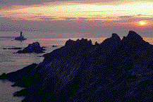
| The same degree of diversity is found along the coasts,
of which France has 5,500 km, with extremely varied scenery. Along
the Channel, in the regions of Artois, Picardy and Upper Normandy, the
coastline is made up of steep, often vertical cliffs. These are cut
into by estuaries such as those of the Somme and the Seine and are being
eroded by the force of the sea. Rocky coasts, which fringe the ancient
massifs and the younger mountains, have a more complex history. The
sea has sculpted them into bays and promontories, sometimes bordered by
islets, as in Brittany, Provence and western Corsica. This has produced
a jagged coastline which has provided harbours for ports but requires consummate
navigation skills. Sandy beaches are found along the edges of plains
and plateaux in Flanders, Les Landes, the Languedoc and eastern Corsica.
Although popular with tourists, these make it difficult to build harbours.
Lastly, marshy coastlines such as the Camargue and Poitevin areas, which
were historically unsuitable for human habitation, can now be visited by
tourists and are often part of nature reserves.
|
|